Well I've had a pretty shitty week...literally, yeah I've had a world beating case of Gastro, now Dr Google says I should of been back to normal in 2 or 3 days, not my fat guts though, hows 5 days of diarrhoea and nausea sound? Every cloud had a silver lining though as I've lost 6 kilograms down the toilet over the course of the week. It got that bad that I was starting to consider that I may have picked up a case of Giardia on one of my recent trips, although I think I may have dodged that bullet as this afternoon, for the first time all week I'm starting to feel a bit better and am confident enough to move more than lunging distance from the toilet. Anyway as there has been no walks for a while I though I'd do another post from our Central Australia trip over Christmas.
 |
 |
| There is a bit of a climb to get the heart started. |
|
My first walk once we arrived in Alice Springs was the Chain of Ponds Walk in the Eastern MacDonnell Ranges. The Eastern MacDonnell Ranges suffer a bit in comparison to their more famous twin, the Western MacDonnell Ranges, but they are definitely worth a look and with some great walks, wild scenery and not many punters to get in my photos I always enjoy my time out there. I've actually written a bit about this walk when I wrote up the
Ridgetop Walk, its worth checking out if you want to see what the country looks like in a more typical drier year. Anyway after bumping my way along the 4wd track to the carpark I pulled on the boots and set off on this fairly short stroll in the mid thirties heat.
 |
That's the gorge that I'd walk back down.
 |
| John Hayes Rock Hole |
|
Now while the walk is short its not quick, it normally involves a bit of easy scrambling (depending on water levels in the gorge) and has a couple of reasonable climbs to get the heart pumping. Leaving the ute I was straight into the first climb, the track climbing steeply through the Witchetty Bush to a lookout high above John Hayes Rockhole, after a short off track section through the spinifex I climbed onto a large slab which gave me a view directly down into the three rockholes of John Hayes Creek as well as being a great spot to photograph the gash in the ground that the gorge has cut.
 |
Taking in the view while getting my breath back.
 |
| I'd have to walk back along this gorge. |
|
Leaving the lookout the good track heads through a bit of head high scrub before slowly arcing around and dropping down to meet the Ridgetop Walk in the bed of John Hayes Creek. Saving the Ridgewalk for another day I turned down stream instead and headed towards the gorge. The sandy creek was damp, with some sections of gently trickling water making its way downstream. As soon as I entered the creek the scenery went up a notch and would continue to improve all the way down, so you'll have to put up with a lot of photos of red rocks, water and blue skies I suppose.
 |
The track is fairly easy across the tops.
 |
I've met the creek, now all I have to do is follow it downstream.
 |
| John Hayes Creek above the gorge made for fairly easy walking. |
|
|
As I entered the gorge proper the rocky ground surface bought the ground water up and I was accompanied all the way through by beautiful cascading water. The gorge walls are not exactly towering into the sky but with the blue sky above and plenty of stark white Ghost Gums clinging to the rock it makes for a very pretty scene. The walking is adventurous as well, I found myself crossing from side to side using slabs of rock to make my way downstream, eyeing the numerous beautiful pools that were beckoning me in but I was trying to keep focussed on reaching John Hayes Rockhole before I succumbed to the temptations of the water.
 |
Heading down the through the gorge.
 |
 |
 |
So many tempting swimming spots.
|
|
|
|
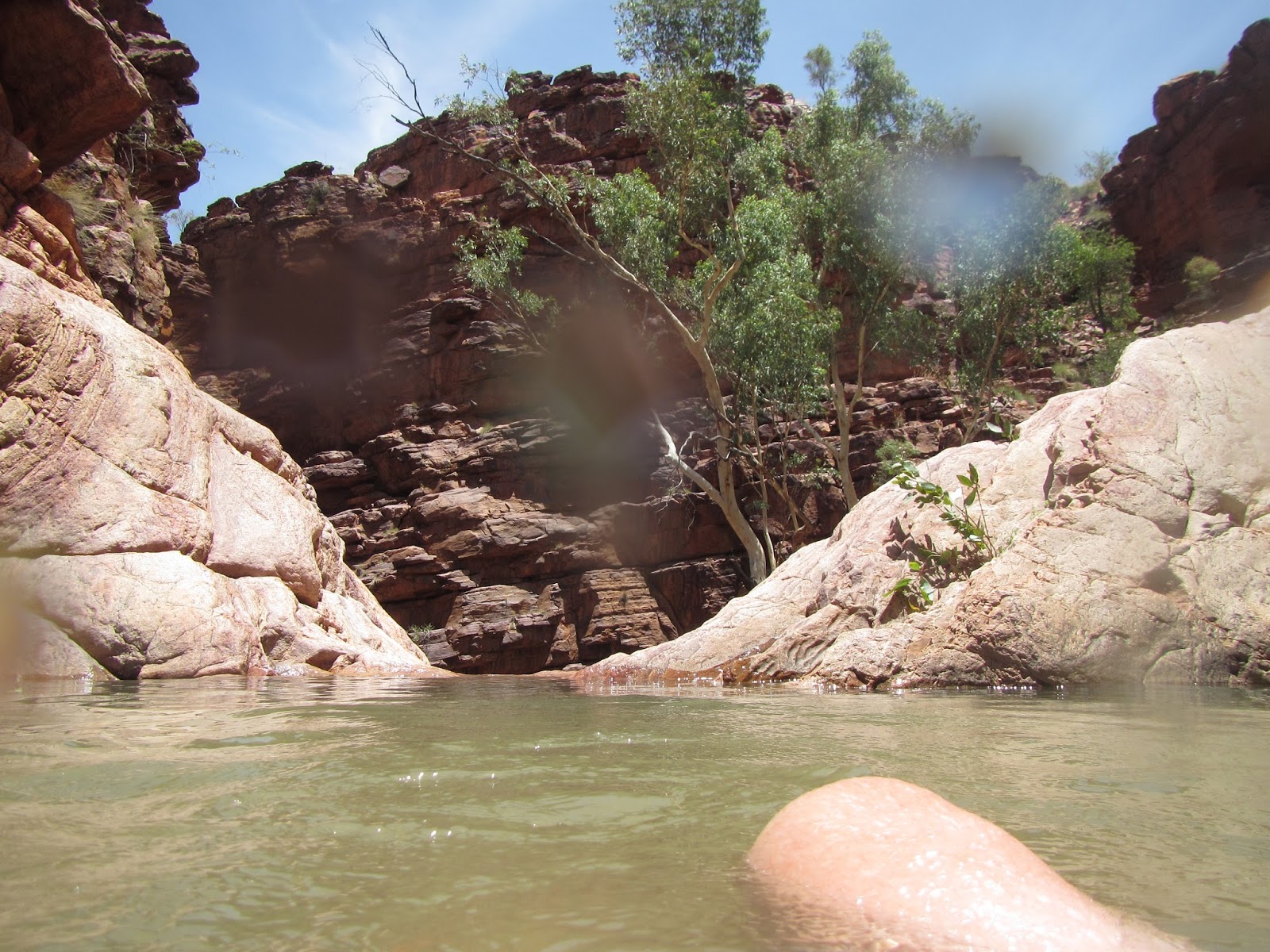
Using some convenient ledges I managed to get most of the way though the gorge without getting wet, however on getting to the last waterhole I realised that there was no chance of getting around this one, it was time to take to the water. Really though with a temperature hovering around the high 30C a bit of a pack swim wasn't really much of a hardship. So after putting the DSLR into its dry bag along with every thing else that I didn't want to get wet, I gingerly inched my way into the red water. The warm water instantly filling my boots as I waded out and around a rocky bluff, the water lapping around my stomach, luckily the water only got just got over waist deep so I was able to climb out the other end with a fairly dry pack, although my boots would take a bit of drying.
 |
Rock hopping my way down.
 |
 |
 |
It was starting to look like the Kimberly.
 |
Hmmm, there is no easy way around this one, time to start wading.
 |
Yeah, I only post the most flattering shots on the blog.
 |
| I had to wade around the bluff on the right. |
|
|
|
|
|
|
Once back on dry land I rock hopped the last few kilometres to the top of John Hayes Rockhole, looking down the rock holes looked incredibly tempting but to get down meant first back tracking a little before climbing out the true right of the gorge and around the rock holes and then descending back to the creek before approaching the rockholes from downstream. The one (only) good thing about this is once again the open tops gave me some nice views of the surrounding country, the rocky spinifix country a bit different to the extensive Witchetty Bush on the other side of the gorge.
 |
 |
| My final views as I climbed around the rock holes. |
|
Once back down at creek level I headed back upstream to the first rock hole, stripping of and grabbing my water proof camera I waded into the deep waterhole, I wasn't stopping here though I wanted to get to the plunge pool that I'd seen from above on my walk down the gorge. So after swimming through the first pool I climbed up stream for a few metres to the second pool, swimming through that one I got the the small waterfall that I would have to climb to access the third pool, the small plunge pool that I'd seen from above. The climb was pretty easy really, the only difficulty being the initial haul out of the water onto the rock face, but that's probably more to do with my hefty bulk than the degree of difficulty of the climb, so being very careful not to slip with my wet feet on the rock I quickly climbed up and into the beautiful plunge pool.
 |
Swimming through the first pool.
 |
| Exploring the harder to reach third pool. |
|
This was my best swimming hole so far on the trip, the deep circular pool was only small but with a cascading waterfall from above and another cascading down to the pool below it was a beautiful spot, natures own infinity pool. After soaking in the water for awhile I eventually decided that I'd better start making my way back to Alice Springs, retracing my watery route through the three water holes at a sloth like pace savouring the cool wetness as long as possible. Climbing out of the water I was dry in about 30 seconds in the desert heat. With John Hayes Rockhole only a couple of minutes from the carpark I was soon back in the ute and bouncing my way back to Alice.
 |
My own infiniti pool.
 |
| The top pool is definitely the pick if you don't mind a scramble. |
|
The Dirt.
The Chain of Ponds walk is in Trephina Gorge Nature Park in the Eastern MacDonnell Ranges, the walk is only short, I walked 4.6 kilometres and climbed 170 metres on this walk. The figures don't really do the walk justice however as despite the short distance the walk is fairly rough. Even if there hasn't been rain recently the walk through the gorge will probably require some easy scrambling, if there has been some substantial rain you may have one or two deep wades as well, all in all it just adds to the adventure I reckon. I used the notes out of
John & Lyn Daly's book Take A Walk In Northern Territory's National Parks, I think the book is out of print but I saw it in a few bookshops in Alice Springs. Taking everything into account I'd rate this as a medium standard walk.
 |
| Heading back to Sam who's waiting for me in Alice Springs, even getting to and from the trail is a bit of an adventure. |


No comments:
Post a Comment