Showing posts with label Desert. Show all posts

Saturday, July 1, 2023

Kangaroo Gap & Alison Saddle Walk - December 2022

Setting off towards Kangaroo Gap - we were lucky on this trip to see so much water about what is normally a very dry area.

Red Gums.

Kangaroo Gap & Alison Saddle Walk - Rawnsley Park Station.

The walking was extremely easy as I followed a shallow valley south (ish).

This old Cypress Pine has seen a bit over the years I'm thinking.

That's Alison Saddle in the middle distance with Rawnsley Bluff poking it's head out in the distance. 

To complete the circuit I walked a nice ridgeline just on sunset.

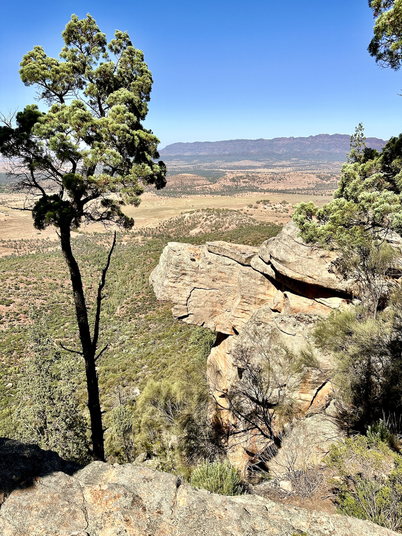
Looking across Rawnsley Park to the outside walls of Wilpena Pound.


Rawnsley Bluff from the ridgeline.


I was dropping down to one of those white roofed buildings in the middle distance.


The Dirt.
According to my AllTrails App I walked around 5 kilometres and climbed about 158 metres on what I'd call an easy grade walk. This is another walk that is on Rawnsley Park Station so I'm thinking that you'd need to be staying there to walk it, the maps are available at reception. I did the walk at the back end of a stinking hot summer day and I'd highly recommend not doing this walk in the middle of a hot day - sunset and sunrise are best for views and wildlife anyway. I used my AllTrails map along with the mud map from the resort.

Relevant Posts.

YouTube Video.


Saturday, June 24, 2023

Warren Gorge Circuit Walk - December 2022

I was off fairly early again today - getting the steepest climb out of the way before the day heated up too much.

Red rock and native pines - I was pretty happy with life.

Looking back towards Quorn from the walks high point.

Warren Gorge Walk.


The view down into Warren Gorge from the high point.

After getting the steepest climb out of the way I was left with a long gentle descent into and through the gorge.


The country surrounding the park is mostly pastural land.


Early morning in Warren Gorge.

There is a good, well amrked track for the length of this walk.

My best go at an arty shot today.

Down near the drive in camp the gorge gets quite spectacular.

It looked like the creek was pretty well dry - although I didn't need water, so I wasn't searching for it.

Warren Gorge.

Warren Gorge.

The Dirt.
According to AllTrails I walked around 5.3 kilometres and climbed about 186 metres on this fairly easy walk. I did the walk counter clockwise which got the steepest climb out of the way and left a fairly long gentle descent through the gorge to finish the walk off with. The track itslef is well marked and clear. Walk very early in the morning (or late in the day) if the weather is hot. There is an extensive drive in camp here if anyone wanted to make a weekend of it. I used my AllTrails map today. 

Relevant Posts.

YouTube Video.


Tuesday, June 20, 2023

Trezona Circuit Walk, Ikara~Flinders Ranges National Park - December 2022

I started the walk beneath leaden skies at the Trezona Camp.

The Trezona Walk utilises sections of the Heysen Trail.

Trezona Walk.

Trezona Creek actually had a fair bit of water in it on this visit.

Trezona Creek.


Heading away from the creek the Trezona Walk passed by some gnarly old native pines.

Following Yanyanna Track towards Middlesight Water Hut.

The Flinders Ranges brooding beneath the grey sky.

Dropping down Yanyanna Track.

Middlesight Water Hut is a fairly uninspiring looking building.


The track has markers where needed.


The local Roos seemed to like these green bushes.

I'm just arriving back at the ute.


The Dirt.
According to AllTrails I walked around 8.4 kilometres and climbed about 141 metres on this easy stroll. This track is reasonably well marked although you need to pay attention on the spots to enter and exit the creek beds. There isn't a lot of shade on this stroll so I wouldn't advise walking the track on a super hot day. I used my AllTrails App today.

Relevant Posts.

YouTube Video.


Heading down to Quorn for a late lunch we witnessed the cloud cascading over the tops of the mountains.


Wednesday, June 14, 2023

Rawnsley Bluff - January 2023

That looks easy enough😬

After starting off fairly easily I soon got into the steep bit.

After getting the worst of the climb out of the way I checked out the side trip to the Wilpena Pound Lookout.

The Elder Range in the distance.

Back on the track and heading towards Rawnsley Bluff.

Rawnsley Bluff.

The view from Rawnsley Bluff.


Looking across the tops towards Wilpena Pound.


The white line in the distance is Lake Torrens.

Looking back down towards Rawnsley Park.

I'm heading back towards the spot where the track drops through a breach in the cliffline. 


Dropping off the plateau.

It was easy walking now back to the ute.


The Dirt.
According to AllTrails I walked around 10.7 kilometres and climbed about 536 metres on what I'd call a medium - hard grade walk. This walk is extremely steep and a little lose in spots so care needs to be taken. Once up on the plateau the walking is easy although when I went through the track was starting to get a bit scrubby in spots - it's still easy enough to follow, however it needs a little concentration. If considering this walk in the hotter months then try and set off close to sunrise, carrry plenty of water and don't be to proud to pull the pin and drop back down to the car park. I used my AllTrails map on the walk this morning.

Relevant Posts.

YouTube Video.


Time to head back for a swim!

And after the swim I've got some work to do!

Pelion Hut to Mt Ossa return, Overland Track - April 2010

Mt Oakleigh from the Pelion Hut heli pad. I think the mountain just visible in the mist in the distance is Cradle Mountain... ... the flat t...