 |
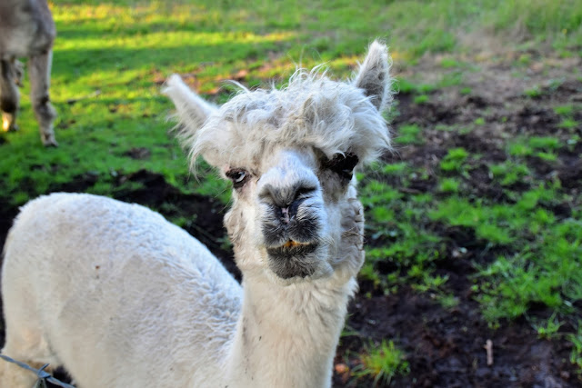
| I had a welcoming committee this morning! |
I'd wanted head over to Lerderderg and re-visit this walk last year however when the day arrived I found that it was closed near Mt Blackwood due to a bushfire (surprise, surprise), so I had to can that idea. Twelve months later I decided that it was time for another go. So anyway, after checking to make sure that everything was open and that the river wasn't too high, early one Saturday I motored over Mt Blackwood to go for a bit of a stroll.
 |
There's an esky hidden in the tree full of carrots.
|
I was greeted at the car park by some furry locals who rushed over to the fence line to meet me. Although on further investigation it appears that my new friends might have been looking for a feed of carrots as the local land owner had an esky full of them stashed in a hollow tree next to the car park. By the time I'd checked out all the animals, taken a before photo of the distant Mt Macedon shrouded in cloud, organised my gear and re-set my GPS it was around 8am when I finally shuffled away from the ute this morning.
 |
There is plenty of room at the end of Lohs Lane to park.
 |
 |
Mt Macedon was cloaked in cloud this morning.
 |
Sulphur Crested Cockatoos.
 |
| The start of my stroll was next to the private driveway. |
|
|
|
|
The start of this walk is a little quirky as I had to pick up what looks like an easement between two rural properties, walking the grassy easement north feels a little wrong however it's the correct route. This grassy easement sidles the eastern slopes of Mt Blackwood which is an old volcano vent, from my untrained eyes it looks like the vent was on the eastern side of the summit in a (now) forested cleft. Once past Mt Blackwood Lower Chadwick passes through a dilapidated gate and enters the Lerderderg State Park, this was the spot that the walk was closed last year. Once in the state park the walking became more like a traditional bush walk in that I was now shuffling through the dry native scrub.
 |
 |
There were a few roos grazing on the slopes of Mt Blackwood.
 |
I followed this grassy easement first up this morning.
 |
| I'm guessing that the wooded area on the side of Mt Blackwood is the old volcanic vent...? |
|
|
|
One of the things I enjoy about walking over at Lerderderg is that the open forest allows for some distant views through the sparse canopy, especially when I'm walking ridges and spurs, and I started to get a bit of that as I shuffled along Lower Chadwick Track. The good walking on this trip really starts when I left Lower Chadwick Track, branching right onto McKenzie Track is was now on a walking track and all was good in my Feral world....for about five minutes! Yes after following the walking track around a knoll I suddenly emerged onto a wide bulldozed firebreak that was running along the ridge top. I guess this firebreak was bulldozed through last year when the fires were here, however whenever and whatever it was pushed through it obliterated a section of McKenzie Track. Now looking at the map it appeared that the new firebreak ran very close to the position of the old track so I didn't muck around too long trying to find the walking pad, instead I followed the wide scar along the ridge for awhile until cresting a knoll the firebreak stopped.
 |
Heading down Lower Chadwick Track this morning was pleasant enough....
 |
....although things improved when I veered onto McKenzie (yeah, I know the spelling is all over the place for some of these tracks - it seems to depend which resource that I'm looking at as to the spelling sometimes!).
 |
Good walking on McKenzie Track....
 |
....for around 5 minutes before I can across this massive firebreak.
 |
Peering into the low morning sun I couldn't see the continuation of McKenzie Track ....
 |
| ....so I followed the firebreak to where it abruptly ended on the top of a knoll. |
|
|
|
|
|
When the firebreak stopped I was effectively off track for a bit now as I sidled my way back a little to the north to try and pick up McKenzie Track a little lower down. After five or ten minutes of cross country action I did indeed intersect with the walking track again and was able to fairly easily follow it down to the Lerderderg River. McKenzie Track is one of the easier ways to drop into the gorge I think, whereas on some of the other routes you'll be scrambling heading down here is just a steep walk. Soon after the views along the river started to appear I dropped down and walked through an area full of old mullock heaps and arrived at a nice bush camp at on the river. This spot would be a very nice camp if I'd wanted to spend the night down here however today it marked the spot to turn right and head downstream for the next few hours.
 |
Once off the firebreak I sidled a little to the north to once again pick up McKenzie Track.
 |
Back on McKenzie Track isn't wasn't long before I glimpsed the Lerderderg River below me.
 |
Mullock heaps at the bottom of McKenzie Track - there is a lot of old gold mining history down here.
 |
There is a very nice grassy shelf above the river at the bottom of McKenzie Track.
 |
| Stepping onto the fairly dry Lerderderg River I headed downstream for the next couple of hours. |
|
|
|
|
Once in the gorge the navigation was pretty straightforward for awhile, I just had to follow the Lerderderg Riverbed downstream for the next five kilometres. Now reading that it all sounds fairly cruisey however walking the riverbed isn't always easy, while the river wasn't flowing there was still a lot of pools which sometimes had to be negotiated. Along with sections of standing water the gorge can also be choked with prickly scrub and log jams in spots, all requiring a little bit of route finding to negotiate. After half an hour of heading downstream I started to recognise some of the surrounding bluffs and spurs, sure enough a few minutes later I started passing by some very old dry stone walls that were slowly being reclaimed by nature. The stone work here is left over from the old Ah Kow Mine ruins, apart from the walls there is also mullock heaps and mine shafts on the river flats. Ah Kow is also the spot where one of the escape tracks from the gorge comes in, although you'll need to look carefully to find it. It's also the track that I used to climb out on my Old River Walk a couple of years ago.
 |
Early morning in the Lerderderg River.
 |
Lerderderg Gorge
 |
There was a good amount of water around for the end of summer.
 |
Most of the gorge was still shaded.
 |
This towering rocky spur...
 |
| ...and this old dry stone wall signalled my arrival at the old Ah Kow Mine Site (and the spot where Ah Kow Track climbs out of the gorge). |
|
|
|
|
|
The Lerderderg River between Oh Kow Track and Bears Head Track is pretty remote, it was also probably the roughest section that I walked today. There were a few sections along here where I was pushing through walls of scrub and in other spots I found myself scrambling up the walls of the gorge a little to pass by pools of water. While the walking was rough the scenery was pretty sweet, the towering red bluffs now lit up in the late morning summer sun being particularly photogenic. Shuffling along it was obvious that I wasn't totally alone down here this morning, yes this place is home to big populations of feral goats, and then there is the snakes - it seems that no visit to Lerderderg Gorge is complete without a snake sighting and today was no different in that respect.
 |
Things can be fairly rough going along here.
 |
This place is home to big numbers of feral goats unfortunately.
 |
There is a nice pool near the Ah Kow Mine Site.
 |
Walking Lerderderg Gorge.
 |
Lerderderg Gorge
 |
My remote swimming hole...
 |
...I've swam in worse, that's for sure!
 |
| The water was bloody cold though, I wasn't lingering! |
|
|
|
|
|
|
|
By late morning the sun had reached the bottom of the gorge and my mind turned to a place to stop for a swim. Finding a suitably big pool of fresh water it didn't take me long to strip off my sweaty gear and jump in, although the frigid water meant that I didn't linger for too long. Suitably refreshed after my quick dip I sat on a convenient rock and drip dried in the warm sun, my revery only broken by the March flies attempting to feed on my exposed flesh.
 |
One my way down stream again - there were numerous pools around.
 |
Sometimes the walking was fairly easy.
 |
This long pool just before the Old River required a bit of a scrub bash and scramble to get around with dry boots.
 |
The Old River gully. Part of the old arching Eucalyptus has gone however it's still fairly obvious. My exit route from the gorge was coming up.
 |
Dry stone walls at the bottom of Bears Head Track.
 |
The last photo from the river before starting my long climb out, it wasn't a bad one!
 |
| Old mullock heaps beside the river at the bottom of Bears Head Track. |
|
|
|
|
|
|
Eventually I could procrastinate no longer at my private pool and it was time to grab my pack and set off downstream again. I was now starting to get relatively close to the spot where I had to leave the gorge to climb back up to Mt Blackwood so I was keeping an eye on my map. The tell walking down stream is to identify the substantial tributary of the Old River coming in from the north. I've been down here quite a few times over the decades so I was fairly confident that I wouldn't have too many issues identifying the spot this afternoon, an sure enough after by passing a very pretty and long water hole I arrived at the dry gully with the over hanging Eucalyptus that is the Old River. Shuffling downstream to the next bend some old stone work and mullock heaps marked the spot where Bears Head Track headed off (there was actually a very small cairn here).
 |
Bears Head Track starts climbing between these two mullock heaps. There is a small cairn in the fore ground. Once up in the trees there is a bush camp and a few markers and all becomes fairly obvious.
|
Once I'd identified Bears Head Track the navigational challenges for the day were largely over however the hard work was still to come. Remember I waffled on earlier about McKenzie Track being one of the easier ways into the gorge, well Bear Head is one of the steepest and toughest. While it maybe steep and loose it also makes for great walking in my opinion, the vertigo inducing precipitous spur sometimes only a metre or two wide allowing for views both up and down the gorge. Eventually, after some reasonably exposed scrambling, the gradient started to ease off a little and after climbing one last rocky bluff I suddenly found myself on some relatively level aground again. If anyone decides to follow me up here then the really steep stuff is over when you reach the forest.
 |
Bears Head Track starts off rocky and rough!
 |
The views back over my shoulder on the climb were pretty good.
 |
Bears Head Track.
 |
Bears Head Track - the spur is very narrow in spots.
 |
Steep climbing on Bears Head Track....
 |
| ....at least I had some nice views to take my mind off the climb. |
|
|
|
|
|
Now the gradient had eased off a bit however I still had a long way to go to climb this spur. It was probably still around two kilometres of climbing before Bear Head Track topped out on a knoll where it intersected with the Blackwood Ranges Track. Now from the spot where Bears Head Track emerges onto the Blackwood Ranges Track I was only a couple of kilometres from the ute...however there is an issue. By far the quickest way back to the ute would of been to turn right along Blackwood Ranges Track and thirty minutes later I would of been pulling my sweaty boots off, the issue is that the track passes through the guts of the Ah Kow Gully Reference Area and is closed to the public. Now as anyone who reads my waffle will know I can play a little fast and loose when it comes to track closures however there are some restrictions that I stick to, areas closed for revegetation, scientific or indigenous cultural reasons are off limits as far as I'm concerned. So anyway after taking a photo of the new wind farm out near Ballan from the closed gate I grabbed my pack and shuffled off into the afternoon summer heat on what is a 4 to 5 kilometre long detour.
 |
One last steep and rocky section....
 |
...and the steep scrambly stuff was over.
 |
Bears Head Track.
 |
I've just topped out on Bears Head Track at the Ah Kow Referance Area gate.
 |
| There's a (relatively) new wind farm over near Ballan. |
|
|
|
|
I was now following old 4wd track for the rest of the walk so things were reasonably easy, although in spots these tracks are very steep and loose. After following the Blackwood Ranges Track east for awhile I turned south along Clifford Track, just avoiding stepping on a very angry baby Copperhead Snake along the way. When Foxy Gully appeared on my right I started to trudge along it as it slowly arced around the southern boundary of the Ah Kow Gully Refrence Area. This part of the walk was through rolling hills of dry Eucalyptus forest and providing the weather isn't too hot then it makes for surprisingly enjoyable walking - well for me anyway. After having a bit of a break resting against a convenient tree I continued on along Foxy Gully Track, there is a grassy gully (Foxy Gully?) that I've always had in the back of my mind as a good potential camp if I ever get around to walking the long distance Lerderderg Track....we'll see.
 |
Blackwood Ranges Track
 |
Looking out across Merrimu Reservoir towards the CBD of Melbourne fro the Blackwood Ranges Track.
 |
I was now trekking around the Ah Kow Referance Area.
 |
Clifford Track
 |
| This little bloke was very toey! |
|
|
|
|
Leaving the gully my track now started a long but fairly gentle climb that would only really finish when I arrived back at the ute. Soon after passing beneath a nice Cherry Ballart Tree and avoiding Grassy Gully Track on my left my route emerged out of the trees. The open rural land signalling the imminent end of today's stroll. After shuffling my way past the farm animals I arrived at the ute, pulled off my sweaty boots, took a photo of the now prominent Mt Macedon and then set off on the easy drive home, happy to have re-visited this great little spot.
 |
I hada bit of a break on Foxy Gully Track before the final climb.
 |
Foxy Gully Track.
 |
Cherry Ballart
 |
I've made it around to the other side of the Ah Kow Referance Area.
 |
| Once on the other side of the reference area I was actually walking the Blackwood Ranges Track again (it's complicated!). |
|
|
|
|
The Dirt.
According to my GPS I walked 19.5 kilometres and climbed 832 metres today. With the Lerderderg River section totally off track and both McKenzie and Bears Heads Track a little vague and rough in spots I'd rate this as a hard day out. Bears Head Track will require some easy scrambling too. It's sometimes a little hard to believe how such a wild place can be so close the CBD of Melbourne I reckon, the CBD from the car park is only around a 50 minute drive! This walk would also be suitable for an overnighter I think, with water generally available from the Lerderderg River, although with the amount of feral goats around I'd be treating any water that I got from the river. Now I have to the throw in a disclaimer here, sections of this walk will require good navigation, particularly picking the spot to leave the river and head up Bears Head Track and also the top of McKenzie Track where the firebreak has obliterated the walking track so don't even consider this walk unless you can use a map and a compass - there is no mobile coverage once down in Lerderderg Gorge. I used some old notes and map out of the second edition of Glenn Tempest's Daywalks Around Melbourne. I also used the old Meridian Lerderderg & Werribee Gorges topo map along with my GPS topo maps.
Relevant Posts.
 |
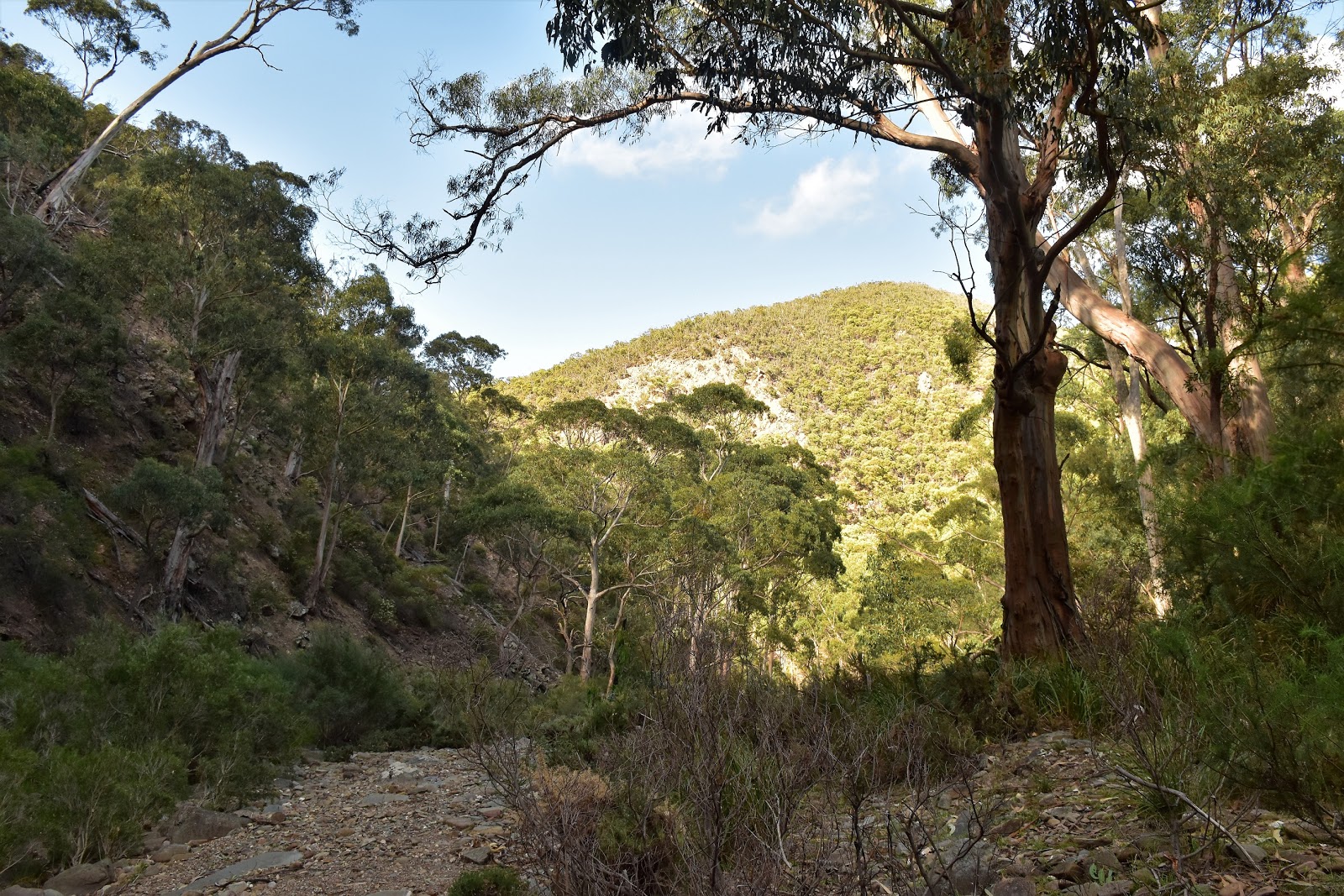
| Open Eucalyptus forest in Lerderderg State Park. |
 |
| Approaching the Lohs Lane car park. That's Mt Blackwood in the background. |
 |
| The clouds lifted off Mt Macedon. |