 |
| Up above Green Gully Canyon. |
Once again I woke up early today to be greeted by a great looking day, plenty of blue sky overhead and and bright sunshine, sweet. Although like yesterday it was bloody cold, today the temperature on my watch was reading -5˚ when I first thought about climbing out of my sleeping bag. I say ‘thought’ as like yesterday, I decided that an early start wasn’t for me today. Eventually though I could procrastinate no longer and I emerged from my down filled cocoon and pulled on all the clothes that I had with me. By 9am I’d managed to pack up, eat breakfast, and clean the hut and it was time to set off on my days walk to Colwells Hut.
 |
I didn't put one in my previous post, so here's a photo of Green Gully Hut.
 |
I warmed up for the day with a meander around the old Green Gully Stockyards.
|
|
Now strait up I’ve got to give anyone reading my waffle a heads up, this post is a bit of a photo dump. Today was a very, very good days walking and I took hundreds of photos, don’t worry I’m not going to post all the photos but it’s still a pretty photo heavy post. That was all in the future though as I shouldered my pack and shuffled off to my first creek crossing within twenty metres, creek crossings would be the predominant feature of todays stroll. Soon after crossing Brumby Creek, Green Gully Creek came in from the north and I’d now be following it, and occasionally walking in it, for the rest of the day.
 |
Heading off I didn't have far to go to reach my first creek crossing.
 |
Leaving Green Gully Hut I crossed Brumby Creek for the last time, this is the same creek that flows past Birds Nest Hut back on day 1.
 |
The sun was very welcome.
 |
| I had an old 4wd track to follow initially. |
|
|
|
Initially I was following an old grassy 4wd track up steam, thankfully for my frigid digits the gorge is pretty open along here and my fingers appreciated the weak winters sun streaming down. The other good thing about walking in the sun was that it meant that it was pretty easy to take photos without dealing with the light and shade conundrum that normally occurs on gorge walks. I mentioned yesterday about the weeds down on Brumby Creek and Green Gully Creek also has it’s share, but I suppose I should put things in perspective a little. I can’t think of another gorge with relatively easy access that isn’t infested with weeds, even most ‘remote’ gorges are now infested and to be honest Green Gully is in a lot better nick than most, especially considering it’s pastural history.
 |
Green Gully Creek
 |
I was pretty excited at this stage of the day to still have dry socks.
 |
| Initially there was generally a way to rock hop across the creek. |
|
|
For the first half hour or so I approached every creek crossing and scouted out ways to cross without inundating my boots with icy water. Some times I’d find convenient rocks to hop across or maybe a fallen tree, sometimes I went for the fast Feral shuffle method, trusting my gaiters and gortex lined boots to keep the water at bay. Arriving at the end of my 4wd track after what must have been 15 crossings of the creek I was still meandering along with dry socks, although from here on things were going to get a bit damp.
 |
Green Gully Creek
 |
I've just reached the end of the 4wd track.
 |
 |
| Luckily a previous walker had left a muesli bar trail for me to follow, smoko was now sorted! |
|
|
|
The 4wd track goes about 5 kilometres into the gorge from Green Gully Hut but the next 5 or 6 kilometres are trackless, well that’s what the information says but there is rough pad in spots. Heading off into the scrub I did indeed find a rough pad which I followed on and off for hours, but to be honest in a lot of cases it was easier to just find my way upstream criss crossing the creek or wading through the water, which was generally only knee deep. Heading deeper into the gorge the scenery got better and better, the walls of the gorge closing in and starting to tower above. The walking was still pretty reasonable with long sections along gravel banks, the flood debris piled high warning that this isn’t the place to be in a flood.
 |
Heading further into the gorge the scenery kept getting better.
 |
Sometimes I waded up the creek for short sections.
 |
There was plenty of flood debris around, this isn't a place I'd want to be in a flood.
 |
When the cliffs opened out a bit there was generally easy walking along the creek flats.
 |
 |
| The water is crystal clear. |
|
|
|
|
|
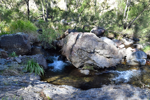
It was around lunch time when I sloshed my way up to the crux of today’s walk, Green Gully Canyon. The rock buttresses towering overhead here are the same ones I was looking down on yesterday from Green Gully Lookout, while things looked good enough from above, down here the
wow factor was definitely ramped up a few notches in my opinion. I’d hoped to arrive here at around lunch time as I’d guessed that this would give me the best chance to photograph the rock buttresses in the sunlight and for once my cunning plan paid off. Before I could drop my pack and grab my camera I wanted to get through this little obstacle though, I mentioned that this is the crux of today’s walk and that is because there is no easy way to get through the canyon without a fairly deep wade. The best option here appears to be the extreme left hand (north) side, there is a pebbly bank under the water near the cliff that is the shallowest spot. With the water being as clear as gin it was a little hard to gauge the actual depth without plunging in, so after packing away the DSLR I waded in, the cold water rising up to crutch height and almost lapping at the bottom of my pack. Just as I was thinking that my pack was going to get a bit damp I was able to climb onto a rock and from there it was just a matter of rock hoping my way up stream until I found a nice flat spot for lunch.
 |
The closer I got to Green Gully Canyon the more closed in the gorge became.
 |
 |
This is the crux of today's walk, Green Gully Canyon. I waded through next to the bluff on the left.
 |
 |
 |
I'd love to do this section of the walk in the warmer months, the wild swimming today would be magic.
 |
| Wading Green Gully Canyon, juggling my walking poles and my camera whilst shuffling through the water....what could possibly go wrong? |
|
|
|
|
|
|
I’m imagining that Green Gully Canyon would be a great spot for swimming in the warmer months but today I was happy enough to just sit on a rock in the sun and dry off a little while I had lunch. After my salami and cheese it was time to grab the camera and explore a little. Green Gully Canyon is a real issue for some of the punters that walk the Green Gully Track but I’d read somewhere that it was actually possible to climb around his choke point, so I decided that maybe I’d climb up and check out the view. Leaving my gear at the creek I headed up a very steep gully on the north side of the creek, not only was this gully steep but it was also loose and I was almost hauling myself up from tree to tree, the creek would want to be pretty high before I’d consider hauling my pack up here to avoid the wade, I’m thinking. With the gradient easing off a little I was able to scramble carefully onto one of the rock buttresses that tower over the creek, the view from up here made the steep climb worth while I’m reckon, the rugged, rocky country having areal remote wilderness feel about it.
 |
The country starts to open up again after passing through the canyon.
 |
Lunch time in Green Gully Canyon.
 |
I scrambled up a gully onto one of the buttresses above Green Gully Canyon to get a bit of an overview.
 |
| Like I said... great wild swimming. |
|
|
|
After safely dropping back down to my pack I headed off on the afternoons walk. The country now slowly opening up again as I headed further up steam, I even got a few long sections of dry gravel banks in the creek to walk along, kind of like a walkers off track freeway I suppose! With the mid winters sun now on it's way down in the north west and the gorge opening up a bit I was really enjoying the views of the surrounding mountains, always framed by the crystal clear water of Green Gully Creek.
 |
Heading up stream from the canyon the valley opened up a bit, there are plenty of beautiful waterholes along this section.
 |
These flat gravel banks in the creek made progress pretty painless.
|
|
Green Gully Creek seems to have quite a few deeper pools along this stretch of the creek and each one taunted my as I shuffled my way past. As anyone who reads my blog would know I’m quite partial to a bit of wild swimming and Green Gully is made for it, however with the temperature hovering around 13˚ there would be no Feral skinny dipping today. I might not of been swimming but that’s not to say I was dry, I’d long ago ceased to worry about crossing the creek with dry boots and was now just plunging in whenever I had the need to cross, I had to be a bit careful with this creek crossing technique though as more than once I shuffled into the clear water to find to find it lapping at my crutch.
 |
 |
We don't get a lot of this type of walking in Victoria, most of our river gorges are a bit more densely vegetated ..... or they don't have permanent water.
 |
 |
| This gnarly old tree has no doubt seen a lot over the years. |
|
|
|
Around 100 photos and a couple of hours after leaving Green Gully Canyon I picked up another old 4wd track, I’d now be following this track the rest of the way up to Colwells Hut. It was around here that I also started to shuffle past piles of fresh cow shit, allegedly cattle haven't been run down here for many years but these steaming piles of poo certainly weren’t that old. Rounding a corner on my grassy 4wd track I came face to face with the bovines that were leaving their calling card along the creek, these cows weren’t happy to see me though and quickly bolted for the hills. The cattle that I saw along here were all in incredibly good nick and had the ear tags in place. It’s very unfortunate for the local farmer Joe that during one of the worst droughts in history his cows have managed to get through his fence and graze on the lush green grass down near the creek, I’m sure he will be shattered when he rounds them up and sends his now, very fat cattle, to a market that the price for cattle has been pushed sky high due to the drought. Like I said, ‘very unlucky’.
 |
 |
It's all down hill from here! I've just met up with another 4wd track... I'd follow this one all the way to Colwells Hut.
 |
| These cattle were in extremely good nick compared to ones I'd seen on the drive in through the drought ravaged mid west of New South Wales. |
|
|
With the cows watching me from the slopes above I wandered the last kilometre or so up stream, after one final crossing I emerged dripping from Green Gully Creek to make the short climb up to Colwells Hut. Colwells Hut is a lot smaller than the other huts on this walk so I was happy enough to have this one to myself, even so I dragged one of the camp stretchers outside to give myself a little bit more room. It was mid afternoon when I arrived here and my first thought was to get the fire going, I had a long day with a big climb in front of me tomorrow and I wasn’t keen to tackle it with wet boots.
 |
 |
 |
| The country was really opening up now as I got closer to Colwells Hut. |
|
|
The National Parks people have done a superb job with these old huts and Colwells Hut was no exception, gas, wood, camp beds and chairs are all supplied. With my boots and gaiters slowly drying near the fire I spent the remainder of the afternoon kicking back reading and listening to ABC local radio, savouring my last night down in Green Gully. With the sun dropping below the surrounding mountains the temperature started to plummet I made a strategic retreat to my chair in front of the fire, only venturing outside occasionally to try and photograph the changing colours as the sun set.
 |
 |
| The beautiful scenery continued for the whole day. |
|
The Dirt.
According to my GPS I walked 17.3 kilometres and climbed 302 metres on this medium grade days walking, these stats might be slightly over the odds a little as I meandered my way up stream taking more than 200 photos, the metres climbed figure also includes my scramble onto the rock bluffs above Green Gully Canyon. So far on my Green Gully walk I’ve shuffled 52.3 kilometres and climbed 1553 metres. Today was a really good days walking, the walk up Green Gully is a very enjoyable and adventurous and the scenery is stunning in spots. The walk today is a walk of thirds, the first third on an old 4wd track, the middle third off piste up the creek, and the last third on an old 4wd track again. The off track is rougher than the previously walked ‘off track’ sections on day 2, that said it’s pretty easy to find your way up stream past the obstacles and adds to the charm of the day in my opinion.
Relevant Posts.
Green Gully Track, Day 1, Oxley Wild Rivers National Park, July 2108.
Green Gully Track, Day 2, Oxley Wild Rivers National Park, July 2018.
 |
| Colwells Hut |
 |
| My first task was to get the fire going to start the boot drying process. |
 |
| The suns dropping behind the surrounding mountains, with the temperature also dropping quickly it was time to head inside. |


