Showing posts with label Day Ride. Show all posts

Sunday, October 31, 2021

Peninsula Link ~ Baxter Trail Circuit Ride - September 2021

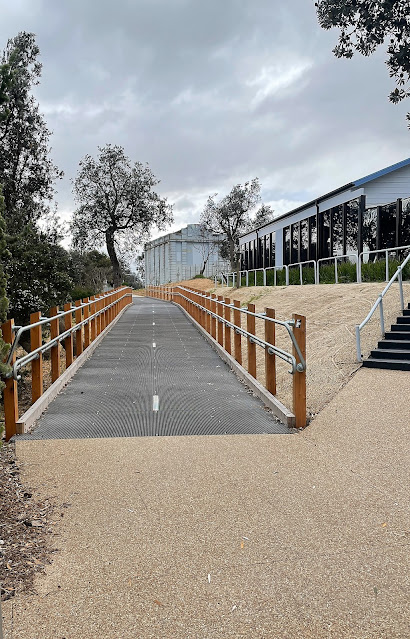
The new shared path heading through Seaford - I'm not sure if this path has been named yet?

With only so many walks accessible in my Covid restricted world I've started to look for some other little adventures to keep me sane. Now I normally use my mountain bike as my daily commuter, so after clocking up 100 kilometres or so on my commute during the week I'm normally pretty keen to get off the saddle and head out some where on foot... however these are strange times indeed! Looking around my immediate area this morning I mapped out a bit of a rough circuit that I figured would keep me busy for a couple of hours, while at the same time let me check out a new section of bike path that hasn't even made it onto most maps as yet. Now this bike ride definitely isn't a MTB Epic, it's actually a ride that could pretty well be completed on any type of bike as it's pretty well all on sealed paths and I was passing through a very urban area, still beggars can't be choosers and this has pretty much been my world now for the best part of the last two years - so I may as well make the most of it!

These Coffee Vans have been doing a roaring trade over our lockdowns.

I started my ride on the north side of the Gladesville Boulevard Bridge.


My little excursion started a few minutes from home at the spot where the Peninsula Link Trail branches off from the Dandenong Creek Trail at the Patterson River Bridge on Gladesville Boulevard. After successfully resisting the Covid Coffee Van that now works out of the carpark beside the bridge I crossed the river dropped down to pass under Gladesville Boulevard and immediately headed off south along the concrete Peninsula Link Shared Path. Now this post is going to be as boring as bat shit if I go into every left/right turn so I'll give that a miss, if just for my own sanity. I now followed followed a fairly convoluted (although well signposted) route as I made my way through the wilds of Patterson Lakes and across the savannah like Seaford Wetlands - hey, I've been locked down for a couple of years so allow me some poetic license! Leaving Seaford Wetlands I faithfully followed my concrete path to cross over the Frankston Freeway and soon after Peninsula Link Freeway to enter the Pines Flora & Fauna Reserve - a small parcel of native bush that has really been my go to mental health spot over the last two years of lockdowns.

The Peninsula Link Trail meandering its way through Seaford Wetlands.

Crossing the Frankston Freeway.

Between the freeways the I passed through a light industrial area in Seaford.


After crossing Peninsula Link the path headed into the Pines Flora & Fauna Reserve.

The Pines Flora & Fauna Reserve.

The Pines Flora & Fauna Reserve.


The Peninsula Link Shared Trail now made it's way back to the freeway and I started a fairly long, but also fairly gentle climb up to Frankston - Cranbourne Road. This section of the ride stays fairly close to the freeway for most of the distance which makes navigation fairly easy, although the occasional road crossings can require a bit of attention as the trail sometimes randomly criss crosses the freeway at these spots. It wasn't navigation that I was thinking about now though, nope the weather was taking a turn for the worse unfortunately with a very cold wind and some fairly persistent showers blowing in off Port Phillip Bay, hmm. Crossing over the Frankston - Cranbourne Road I stopped and pulled on my rain jacket under some pine trees while I consulted my maps. With the cold rain coming down I decided to abandon a plan to head all the way down to Baxter and instead I dropped down the Baxter Trail and followed the railway line all the way down to Frankston - the gentle decent down to Frankston was a highlight of the ride really, although I had to be a little careful barrelling down the wet track.

The rain got a little more insistent after I crossed over the Frankston - Cranbourne Road.

Time to pull on some wet weather gear I think.

I dropped down the Baxter Trail into Frankston.

The decent down Baxter Trail was quick... and a little slippery.

I'm about to emerge on to the streets of Frankston.


My long downhill run came to an end fairly suddenly when the Baxter Trail emerged onto Playne Street in Frankston. The trail finished here and I was now going to be freelancing a little as I made my way up the bay back home. There has been a lot of civil engineering going on along the Frankston railway line that I knew had included some new bike paths, what I didn't know was exactly where the path started, or if the path ran all the way up to Carrum. After consulting Google Earth before leaving home I'd thought that I could pick up a trail starting a couple of kilometres north of Frankston on Dandenong Road East, so that's where I was heading now as I splashed my way through the wet backstreets of Frankston. With the train line to guide me there was no chance of going to far wrong here, and arriving at the spot that I'd noticed on the satellite photos I did indeed find a shiny new concrete path.

The start of the new trail is beside Dandenong Road East and is a fairly low key affair.

Passing by the Kananook Station - it was around now that I started to suspect that this new trail would take me all the way up to the Patterson River.


The next question that I had to resolve was how far did this path go. Leaving aside the fact that the path started in a very nondescript area of Frankston with nothing in the way of signage to signal it's existence (that I noticed anyway), the remainder of this path turned out to be well signposted with a street sign style of signage. Thankfully the rain had pretty well stopped by now so all I was contending with was the biting south westerly wind howling in off Port Phillip Bay as I weaved my way up towards Carrum beside the railway line, well the wind and also the fact that I hadn't done a ride of this length for the last couple of years of our lockdown life here in Melbourne so my bum was starting to feel it a bit! It turned out that the new concrete path (I'm not sure if it has a name) ran all the way up to Carrum (and beyond), the crossings of Kananook Creek and then the Patterson River being the scenic highlights. The Patterson River was my jumping off point though, so after crossing the river I picked up another shared path that headed up river along the north bank and rode the last three kilometres of my mini adventure enjoying not only the river views but also the views of the distant Dandenong Ranges.

There has been some serious money spent on this new path.

The new trail crossing Kananook Creek.

After crossing the Patterson River I left the new path and followed the river side path back to complete the circuit.


The Dirt.
According to my GPS I rode around 31.7 kilometres and climbed about 183 metres on what I'd consider an easy bike ride. The trails that I rode today were all sealed except for the last three kilometres along the Patterson River so the ride is pretty well suitable for any type of bike. The Peninsula Link Trail, Baxter Trail and Patterson River Trail are well mapped and signposted although the new trail alongside the Frankston Railway Line isn't as commonly mapped (yet) - although once I found the start of it in Frankston I found it well signposted. To be honest I didn't really need a map on this ride as I've ridden most of these trails numerous times over the years, although I did have my GPS topos and my phone maps if I needed them - and I did do a little research on the new trail before leaving home.

Relevant Posts.


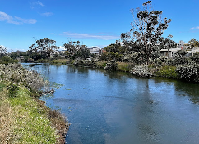
The Patterson River Path is a nice one - although I am biased as it's also my back yard!

The end is in sight.

Friday, July 3, 2015

Rottnest Island - December 2009


Rottnest Island was called Wadjemup which translates to 'place across the water' by the Wadjuk people. Archaeological finds on the island suggest that it may have been inhabited up to 30,000 years ago, although when the sea's rose and the land bridge connecting it to the mainland disappeared it was uninhabited again until the Europeans arrived. The first known European to find the island was a Dutch explorer Willem de Vlamingh who re discovered and named the island in 1696, he named it Rotte-nest which translates to 'rat's nest' in Dutch because of the king sized rats on the island, which were actually quokkas. After European settlement the island was used for a prison which at first incarcerated our indigenous people and a little later during WW1 and WW2 interned any nationalities that were thought to be a threat. Now days the island is an escape from Perth about 2 hours away by ferry, as well as being the home to an extremely offensive wind turbine that obviously really annoyed Mt Abbott.


Perth


We were staying in the Perth CBD so booked a the ferry leaving from the Barrack St Jetty in town, the advantage of that is that we got a nice cruise down the Swan River to Fremantle before we headed out into the Indian Ocean over to Rottnest. The cruise along the river takes you past some pretty exclusive cliff side real estate which backs on to Jutland Parade. For those that don't know Jutland Parade regularly features in articles about the most expensive real estate in Australia, it's definitely 'lifestyles of the rich and shameless' territory, think names like Bond, Hancock, Rinehart, and you start to get the picture. Sailing through Fremantle we cruised past the 'The Oceanic Viking' this was the customs ship that had just returned to Australia after it took some Sri Lankan asylum seekers aboard only to have them refuse to disembark at our off shore processing centre in Indonesia. In hindsight this was one of the first glitches in Rudd's time in power as it made him look indecisive to some people, it also gave the Murdoch Media and the conservatives something to crank up a bit of a dog whistling scare campaign about, we still haven't got an acceptable solution to the refugee problem even now due to the politician's playing to the 'base' instincts of a (unfortunately) large section of our population. Grrr.... 

There's a bit of money here I'm guessing.

Fremantle.


Anyway, enough crapping on already, what about Rottnest. Docking at the jetty at Thomson Bay the first objective of the day was to secure ourselves a couple of hire bikes to get around the island on as there are no private cars on the island. The island is only small but at around 11 kilometres long and 4 wide its still too big to walk around easily, so the main options are push bikes or a little bus that circles the island every hour and allows you to jump on and off. Once on our trusty treadlies we headed off on our circumnavigation. I'd like to tell you stories of all the little bays and beaches that we visited but looking at the photo's I can't remember any of the names (don't forget the blog was years away) so instead I'll probably end up posting a lot of photo's with no captions. What I do remember was riding past a never ending selection of stunning swimming spots, I was able to regale Sam with my adventures on Rottnest last time I was on the island when I was 19 years old, although for some reason Sam had a bit of a glazed look in her eyes that seemed to say 'yeah, your not 19 anymore old man!'


There are a few wrecks around the island.


By early afternoon we had found ourselves a beautiful small cove on the north coast that was protected from the Fremantle Doctor by some rocky bluffs, this was a great spot for a long lunch and a relaxing swim and we were lucky enough to have the little cove to ourselves all afternoon. It pays to plan any visit to Rottnest, or for that matter any beach near Perth around the almost inevitable Fremantle Doctor sea breeze that comes in. The term 'breeze' is a bit of a misnomer as the Fremantle Doctor is more 'strong wind' than 'breeze' and while it provides great relief from the often sweltering temperatures inland, it makes life a misery on any exposed beach with the sand seemingly able to penetrate every orifice of which you'll be removing sand from for days.


Our little cove.

We were protected from the Fremantle Doctor a bit by the rocky bluffs.


After our swim we started to head back to the Thomson Bay jetty, on the way we came across some of the incredibly cute and docile quokkas. The quokkas are what Willem de Vlamingh mistook for giant rats, they are actually part of the macropod family meaning that they're related to roo's and wobblie's. The quokkas are too docile and friendly for their own good sometimes as some of the visiting bogans used to play 'quokka soccer' with them and kick them to death, how fucked is our species sometimes! Now days there is a large fine protecting them, but for fucks sake....


This post seems to be wandering into some dangerous territory in politics and the environment so I'd better get back on track lest everybody thinks I'm one of 'them' as my mum calls me . Mum thinks 'them' (spit it out with venom and you'll understand what she thinks) is anyone to the left of Abbott, Bernardi or Abetz, so I guess I'm guilty as charged! After our quokka encounter we dropped off the bikes and once again boarded the ferry for the two hour trip back to Perth, after a big day a lot of the punters dropped off to sleep on the return journey. The trip back up the Swan River in the late afternoon is definitely worth staying awake for though, this place reeks of money.


We used the hire bikes to get around the island.

The Dirt.
Rottnest is a great place to visit, it feels a million miles away from civilization even though you can still see the high rise buildings of the Perth CBD in the distance across the Indian Ocean. The beautiful white sand bays and coves on the island are stunning and the island is big enough that you can normally find your own patch of sand that isn't to crowded or windy. The thing with Rotto is that by the time you get there and with the need to catch the last ferry off the island, which sometimes leaves before 4pm, then you don't actually get enough time on the island in one day in my opinion. One day is fine for a first time quick visit but to really explore the island and let it sink in you would need to book some accommodation over there, that's what we'll probably do next time. Apart from the stunning coastal scenery the other highlight on the island is the quokkas, they are incredibly cute and you're almost guaranteed see them on Rottnest.

The Perth CBD is visible in the distance.
Sailing back up the Swan River in the late afternoon.


Thursday, March 12, 2015

Grand Ridge Rail Trail - March 2015

This marks my first attempt to write up a one day bike ride (I did a post about the multi day Mawson Trail somewhere on the blog) so I'm on a bit of a learning curve as to what constitutes a good post about bike riding. The first thing I've learnt is that I'll have to carry my small camera as I got sick of stopping, taking my pack off, getting the camera out, holding everything including my bike, and then trying to get a decent photo. I think my small waterproof camera in an outside pocket will probably be the go although the photography will suffer. The second thing I noticed is that I just didn't want to stop to document the experience, especially if I was barrelling down hill. I'm not sure how I'll fix that!
The start of the Grand Ridge Rail Trail at Boolarra.
The plan for the day was to head to the small town of Boolarra in the Strzelecki Rangers in South Gippsland and ride up to Mirboo North for lunch, before gliding back down to Boolarra and heading home. About ten minutes into my two hour journey to the trail head I realised that I'd forgotten my bike lock, it looks like lunch was going to be somewhere I could keep an eye on the bike now, oh well. Leaving the ute in the nice park at Boolarra I saddled up and after resetting the GPS I was off up to Mirboo North. At 13 kilometres each way this wasn't going to be a particularly long ride (I ride further each way to work and back every day) so I was pretty confident that today would be a cruisey day.
The Grand Ridge Rail Trail on the climb to Darlimurla.


The trail climbs gently most of the way up to Mirboo North, passing through agricultural land, pine plantations and a fair bit of native vegetation as well. The surface of the rail trail was either crushed granite or a few short sections of dirt which all made for easy going on my mountain bike. I figured that I'd stop a bit on the climb up and then coast back down from Mirboo North and that's how it turned out. The first points of real interest to me were a couple of fairly substantial bridges that had been put in, and a little bit later the old Darlimurla Station.  A lot of this infrastructure was funded by the Bushfire Recovery Fund after bushfires tore through here in January 2009. The fund was set up to get the small local communities back on their feet.
The trail crosses a couple of these substantial bridges.
The site of the old Darlimurla Station.
Leaving the old Darlimurla Station the trail continues its climb to Mirboo North, the climbing was all middle ring stuff, nothing remotely steep. The country changed a bit after leaving Darlimurla Station and started to pass through mostly native vegetation, with its ferns and eucalypts it was an enjoyable section of the ride. After about an hour I arrived at the Mirboo North trail head having barely raised a sweat, now I had been planning to go to the Grand Ridge Brewery for lunch but after checking out the bike security situation I decided that I'd better just head to the old standard fall back, the bakery.
Between Darlimurla and Mirboo North the trail passes through more native bush.


Grabbing a pie and a coke from the bakery I sat in the park in the shade and watched the world pass by. Mirboo North was really humming today, its been a long time since I've been up into the Strzelecki Rangers but my memories were of an area that had largely been overlooked by tourists, today however it was bustling with all manor of punters, maybe that's because it was in the middle of a long weekend or maybe that's the way it is now? Anyway, after finishing lunch I pointed the bike back down towards Boolarra and let her go, the gradient was almost perfect, never steep enough to get up a stupid amount of speed but enough gradient to make peddling largely redundant. Less than thirty minutes after rolling out of Mirboo North I coasted to a stop beside the ute, it had been a nice easy introduction into one day bike touring.
The Mirboo North end of the Grand Ridge Rail Trail, that's the Grand Ridge brewery above the trail.


Lunch in the park at Mirboo North.
The Dirt.
The Grand Ridge Rail Trail is a short family friendly adventure. I rode a total of 26.2 kilometres and climbed 216 metres on my return journey. I started at Boolarra and climbed up to Mirboo North to get any climbing out of the way in the first half of the ride.  Mirboo North has a wider selection of places to eat. Boolarra is two to three hours from Melbourne so it is a bit of a drive to get there, and the Strzelecki Rangers are famous for the amount of precipitation they get so check the forecast.


Pelion Hut to Mt Ossa return, Overland Track - April 2010

Mt Oakleigh from the Pelion Hut heli pad. I think the mountain just visible in the mist in the distance is Cradle Mountain... ... the flat t...