Sunday, July 30, 2017

Dandenong Creek Parks - July 2017

The wetlands around Dandenong Creek.
Once again I had grand plans for this Saturday, the original plan was to head over to the Grampians and climb Mount William by a less well-worn route. There was a problem though, the BOM were forecasting the strongest winds for the year to hit Victoria on Saturday. Now anyone reading my blog might think that the Feral Walker is fairly fearless reckless, and you'd be pretty right, well at least about the reckless bit! While I don't mind setting off on a long walk in the desert in the summer heat or heading into the High Country in the middle of a winter storm there is one particular type of weather that I'm not that keen on and that's wind. You see I can always prepare somewhat for extremes of heat or cold and therefore have some degree of control over the situation, but if a branch decided to break away in strong wind and I'm in the wrong place at the wrong time then it's just dumb luck what happens next and I'm not that comfortable about that. Now sometimes I've been caught out on multi day walks when the wind comes up but there is not much I can do about that, but to head off on a day walk into a park full of eucalyptus trees when I know that there are high winds predicted would be a bit irresponsible, even for me.
This is the 800 metre mark in Mr Chapman's notes, my starting point today.
So anyway enough of me waffling on about my issues. Not wanting to totally write the day off I cast around a bit looking for a plan B, after briefly considering and ruling out a beach walk (being sand blasted isn't much fun either) I decided that maybe the best course of action would be a suburban walk. After perusing my walking guide book collection I decided on a Chapman Walk called Dandenong Creek Parks. Arriving at the designated start point on Nortons Lane nice and early my plan hit it's first hurdle for the day, it looked like every soccer mum in Melbourne and their huge shiny 4wd was in the car park, it seems that I'd stumbled upon what looked like a private school cross country running event. After cruising around the car park it was obvious that I wouldn't be parking around here this morning, with apathy now threatening to overtake me I decided to head down High Street Road and see if I could get a park before giving up entirely and heading home to drink coffee and read the papers. Thankfully I discover a car park near the bridge over Dandenong Creek, after consulting my walking notes I realised that it would be a simple matter of picking up the walk at the 800 metre mark.
Heading into Shepherds Bush.
All was good as I reset the GPS and headed off, I was now heading into a bit of native scrub called Shepherds Bush. The notes suggested that after a couple of minutes I should cross Dandenong Creek on a substantial footbridge, yeah you can see where I'm going here, can't you? My substantial bridge was not actually there anymore, I didn't notice even the remnants of a bridge as I made my way along the eastern bank of the creek. Unless you have a bit of walking guide book OCD it doesn't really matter that much, I just followed another path through Shepherds Bush and stayed on the eastern side of the creek, I could visit the western side on my return journey. This track was actually quite good, it stayed fairly close to the muddy creek, sometimes rising up higher as the creek wound around a low spur which generally gave me some good views.

I was never far from Dandenong Creek today.
This first section actually feels a bit like a bushwalk.
Eventually I popped out of the scrub onto the shared path that is The Dandenong Creek Trail, this multi use path would now be my route south to Jells Park. The Dandenong Creek Trail betweens Shepherds Bush and Jells Park borders the native bush of Dandenong Creek on one side and some remnant open farmland on the other side. It was along this section that the wind made it's presence felt, the creek side trees copping a battering as the wind howled across the open paddocks. The good news was that although it was a bit breezy the sun was out and it was a fairly warm day for the middle of winter, the blue sky always makes taking a half reasonable photo a little easier.
The shared Dandenong Creek Trail is very easy walking.
The section of today's walk along The Dandenong Creek Trail between Shepherds Bush and Jells Park stay fairly close to Dandenong Creek.
The Cootamundra Wattle was looking good today.
It might be mid-winter but apart from the wind it was a nice day today.
Arriving at Jells Lake I took the left hand fork of paths and commenced a clockwise circumnavigation. I've written up a walk at Jells Park before, Jells Park always makes a pleasant place to walk and today was no different as I made my way around the lake. Last time I posted about a late afternoon walk here so the today's early morning ramble provided a different perspective. My walk around the western side of the lake took me through the Jells Park Conservation Area and I spent some time trying to get a reasonable photo of some of the bird life. Now with my complete lack of skill in taking photos of our feathered friends all that I was able to capture was some of the numerous waterbirds that call the lake home, I guess that I'll leave the faster moving birds that live in the bush for people with a little more talent.
Jells Lake from the conservation side.
Three is no shortage of waterbirds calling Jells Park home.
I basically stayed right as I circumnavigated Jells Lake.

Leaving the fenced conservation area I passed below the tearooms as I made my way around the rest of Jells Lake, the large open grassy slope deserted today. Soon enough I re-joined my outward route and headed back up towards Shepherds Bush along The Dandenong Creek Trail, sharing the trail with a few other walkers and bike riders. Arriving at Shepherds Bush I kept left and headed towards Patterson's Bridge. Crossing the creek again I walked a little further before picking up a lesser trail (Paperbark Track) on the right, this trail stays fairly close to the bank of Dandenong Creek and was the best walking of the day, the verdant green vegetation giving it a bit of a remote feel even though I was in the middle of Melbourne's sprawling eastern suburbs. Slowly making my way around this short wild section I all to soon met back up with the main path, almost immediately entering Napier Park and it's many manicured sporting fields. The walk was coming to it's conclusion though, after meeting High Street Road I crossed Dandenong Creek again back to the small car park that signalled the end of my stroll.
The casuarina's were copping a beating in the high wind.
Jells Park isn't all nature though.
This large grassy area below the Jells Lake tea rooms is normally full of people picnicking, being in the middle of winter it was a little quieter than normal today.
Heading back towards Shepherds Bush.

The Dirt.
I walked 8.4 kilometres at an average speed of 4 kpa, with 124 metres of climbing involved I'd rate this as an easy walk. Now as I mentioned earlier this is a walk from the House of Chapman, loosely based on walk number 19 out of the first edition of Day Walks Melbourne. The main difference between the walk that I did and the walk as written up is that I missed the short uninspiring section up to Nortons Lane and that the bridge over Dandenong Creek in Shepherds Bush has long gone which meant that I stayed on the eastern bank until I met The Dandenong Creek Trail. This is a nice enough walk if you are looking to get out for a few hours, the walk is easily modified and is suitable to both the old and the young. A Melways street directory would probably suffice for a walk around these suburban parks, Parks Vic would also be worth a look to see if they have any information online.
Relevant Posts.
Dandenong Creek below Patterson's Bridge in Shepherds Bush.
They have to be taking the piss don't they? Swimming and Dandenong Creek are two words that shouldn't appear in the same sentence I don't think!
Paperbark Track, Shepherds Bush.
I don't think Paperbark Track sees a lot of walkers.
Looking back the native scrub of Shepherds Bush from Napier Park.
The ute is visible on the other side of my final bridge over Dandenong Creek.

Thursday, July 27, 2017

Cyathea Falls, Tarra-Bulga National Park - June 2017


On my recent visit to Tarra-Bulga National Park I decided to drop down Tarra Valley Road and check out Cyathea Falls. I'd spent the previous few hours wandering around the area closer to the visitor centre up at Balook, but with a couple of hours of daylight left I decided to check out this little waterfall before heading home. After safely making my way down the incredibly narrow and windy road I pulled into the Tarra Valley Picnic Area to find it almost empty. After re-setting the GPS I took couple of photos of the picnic area surrounds, before then heading off through an archway into the wall of greenery on my way to the waterfall.

The very wet Tarra Valley Picnic Area.
It's a very grand start to the walk, the stone work is starting to resemble an Inca ruin.
Now once again this post is going to be very heavy on the photos I think, the walk is less then 3 kilometres long (well less, actually) but the cool temperate rainforest is absolutely beautiful. Now while I'm as interested in trees as the next bloke, the rainforest through here really impressed me today. After leaving the picnic area the track heads up stream along the Tarra River for a few hundred metres, crossing and re-crossing it on good bridges . After a few hundred metres the track divides, I took the imaginatively named West Track to the falls and would return to the car park via the East Track. West Track climbs a bit up the steep sided valley of Tarra River, the track staying in the dripping wet rainforest but at the same time allowing for glimpses through the dense canopy of the huge mountain ash trees that were towering above higher up the hill.
To start with I followed the infant Tarra River up stream for awhile.


I decided to head along West Track on the way up to the falls, there was no particular science in that decision though.
Above the rainforest I was getting glimpses of the towering mountain ash.

After the track curves around eastwards it contours high above another damp gully for awhile, this spot is particularly good for getting good photos of the dense covering of ferns down closer to the creek. Eventually I met up with the East Track and took the short side track up to Cyathea Falls. Now Cyathea Falls aren't exactly huge, in fact visiting towards the end of one of Victoria's driest June's ever there was just a trickle dribbling down the rock slabs. Apart from the fact that there wasn't much water to be seen it's also pretty hard to get a clear photo of the waterfall, the view being partially obscured by ferns and with me being a stickler for rules (?) I thought it was best not to go off piste to get a good shot. 
If ferns float your boat then you need to consider this walk.
Cyathea Falls was just a trickle today.
Retracing my route a bit I headed back down East Track towards the car park, East Track was another beautiful walk and there were plenty of excuses to stop and try and get another photo, each one I was sure would capture the essence of this place. Actually you might notice that my average speed was pretty slow on this stroll, that's not because of any difficulties with the track or the terrain, no it's more to do with me aimlessly wandering around checking out the verdant green forest. East Track is slightly shorter than West Track and it wasn't long before the loop was complete and I was walking the last few metre back up to the ute, climbing back up the steps to the car park the with the archway framing the scene it almost felt as though I was entering a cathedral.


Like West Track, East Track makes for very easy walking.
The Dirt.
I only covered 2.4 kilometres and climbed 55 metres at an average speed of 3 kph on this very easy stroll. This is a very nice little stroll if you appreciate rainforest and cascading creeks. The paths themselves are also very well constructed and easy to follow, the walk is suitable for young children and the elderly, although there are quite a few steps particularly on West Track. Cyathea Falls would be best seen after some good rain I think, they were a little under whelming today I thought. Now if you do visit the falls it would be possible to climb onto the rock slabs beside the falls to get a photo without ferns in the way... but the area is signposted as a revegetation area, now how much vegetation is ever going to grow from these bare rock slabs is a little debatable, so I guess you have to do what your conscious tells you here. This walk was written up by John & Lyn Daly in their Take A Walk in Victoria's National Parks book. Parks Vic also have enough free information online to complete this walk safely with.
Relevant Posts.

The forest was literally dripping wet this afternoon.


Climbing back up to the ute, the archway framing the scene.

Sunday, July 23, 2017

Eagles Peaks, Alpine National Park - July 2017

Looking back towards The Bluff from Eagles Peaks. I have warn you that this will be a very photo heavy post I think.
Over the years I've driven past the start of the Eagles Peaks tracks on numerous occasions, both the Sheepyard Flat and Eight Mile Gap track heads, but on all my other visits to the area I'd been heading to points further afield. With a promising weather forecast this Saturday I decided to head up and see what I'd been missing. For a change I'd come pretty well prepared today, being mid winter in the Australian Alps it pays to not take too many chances, so on top of the normal emergency gear today I had my snow shoes in the ute as well, I'd make the call on whether to use them when I arrived at the car park at Eight Mile Gap. Driving up I followed my usual Saturday morning routine. Take a way toasties and coffee from the golden arches, followed by a long drive watching the ambient temp hovering between 0 and -4 at the same time being entertained by ABC news radio going through the latest cluster f*#k coming out of the white house, this week's entertainment supplied by Shaun spicey Spicer and not the orange buffoon for a change.
It was -3 when I set off from Eight Mile Gap this morning.
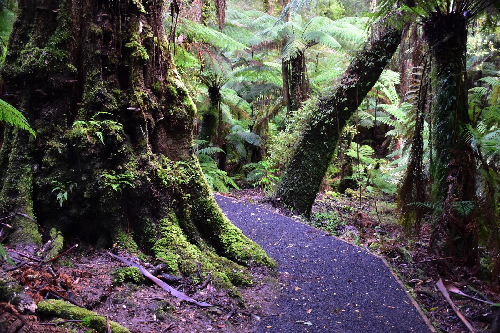
Pulling up at deserted car park at Eight Mile Gap at around 9am I quickly made the call to leave the snow shoes in the ute, the drive up from Sheepyard Flat had given me enough glimpses of the higher country though the trees to have me confident that I wouldn't need to lug the extra weight today. Resetting the GPS I set off up the wide trail, this was the first surprise of the day, it looks like the track has recently been cleared, so instead of pushing through over hanging scrub I was able to climb without getting soaked by the wet vegetation. So apart from a few sections of bracken crowding the track the climb was fairly easy really, the bonus was that as I climbed higher I started to get some good views of the huge snow covered cliffs of The Bluff through the trees. 
I was pleasantly surprised to find a clear track.
Climbing higher the vegetation started to get a bit more stunted and the views opened up.
The climb up to the ridge is fairly easy.
There was a little bracken crowding the track in a couple of places.
I'm just arriving on to the ridge that I will now follow to Eagles Peaks.
A kilometre or so after leaving the ute the track arrived on top of a ridge that I'd then follow all the way to Eagles Peaks, the ridge top walk ramping up the scenery meter even more. I'd walked through patches of snow on the climb up to the ridge but from here on the snow would be fairly constant, if not overly deep. Heading west along the ridge the bulk of the eastern most and highest of Eagles Peaks started looming through the snow gums. When I managed to remove my eyes from the huge red walls of Eagles Peak and glanced to the south west the snow covered ramparts of Mount McDonald held my gaze. The rest of the walk until I returned to this spot much later in the day would now be a fair bit slower, not only due to me being careful on the snow and ice covered rocks but also the fact that the scenery was now stunning in every direction.
I'd more or less be in snow now until I returned later in the day.
Eagles Peaks looming through the alpine scrub.
At 1446 metres that is the highest of Eagles Peaks.
My climbing ridge, it doesn't look that steep does it?

After a slow and careful walk along the ridge it started to climb up steeply to the top of the highest of Eagles Peaks. The climb up here is steep and sections of it are fairly close to some serious drops, with the patches of ice on the bare rock it focussed my mind a bit. Once I'd carefully made my way to the top I was rewarded with a 360˚ view, apart from the The Bluff (which was in view for most of the walk) I now was looking across to Mount Buller and Mount Stirling. I now wandered across a series of knolls and saddles to the extreme southern most knoll, this spot is slightly out board from the main Eagles Peaks ridge and probably offers the best vantage point back to the ridge that I'd climbed.
The climb was made a little tricky by ice in some spots.
There are a couple of snow gums on top of the highest peak.
This outlier knoll slightly to the south of the main Eagles Peak ridge line probably gives the best view.
It's steep country though.
Have I mentioned that it was a superb day today?
That's Mount McDonald from the outlier knoll.
And that's my climbing ridge.

Carefully making my way back to the main ridge line I set off on a trip out to the western most of Eagles Peaks. This walk once again consisted of a lot of climbing and descending interspersed with small saddles, the saddles in particular making for some sublime walking as the snow had settled a little deeper in the sheltered spots. It was slow walking though, I'd initially thought that this whole stroll would only take me two to three hours but it was already after lunchtime and I was still heading away from the ute. Climbing up one last snow covered knoll I was now now at the final knoll, the continuation of the track being the snow covered spur leading down to Sheepyard Flat. I wasn't going down to Sheepyard Flat today though, from this point onwards I'd be retracing my route back to the ute at Eight Mile Gap.
The one constant today were the walls of The Bluff.
The summit ridge of Eagles Peaks isn't exactly flat.
The saddles had probably the deepest cover of snow.
The western most of Eagles Peaks.

Before starting back I once again stopped for a minute to take it all in, I now could see the snowy summit of Mount Howitt poking out in the distance, the Cross Cut Saw, Mount Buggery and Mt Speculation were all visible in the distance from this peak. This was also the closest that I got to the Mount Buller and Mount Stirling complex, with Buller in the foreground and the snow covered summit of Stirling peaking out from behind. With my SD card threatening to melt down I started the slow walk back, the good news for me being that even though this walk was effectively a retrace the different direction meant that there was always something else to stop and photograph.
Mount Buller
Mount Stirling in the background.
The Bluff
The flat snowy summit of Mount Howitt peaking out above Square Head Jinny, the jagged teeth of the Cross Cut Saw is to the left a little.
The ducks guts of Victorian alpine walking, the Cross Cut Saw, Mount Buggery and Mount Speculation.
Making my way slowly back to the highest peak I started a very slow and careful descent, the snow on the open rocky areas having noticeably thinned out over the course of the day. Once again it was a slow walk along the precipitous sections of the ridge before the track dropped off the crest and started the descent back down to Eight Mile Gap. Once off the ridge it was a quick and easy descent all the way to the ute. I arrived back at the ute shortly after 3 pm, it turns out that the walk took me almost 6 hours today. Now while I am old and fat a fair chunk of the day was taken up taking photos, but still 6 hours made for a fairly relaxed pace.
Making my way back the scenery was still impressing me.
Following my foot prints back.
There were plenty of wild dog prints around :(
The closest thing to a selfie today.
The Dirt.
I walked 9.6 kilometres at an average speed of 2.4 kph (yeah, I told you it was a relaxed pace!), and climbed 848 metres on this medium grade walk. The only walking notes that I know of for this walk are by Glenn van der Knijff in his 2004 edition of Bushwalks in the Victorian Alps book. Now I've probably mentioned this before but if there is anyone who might rival Mr Chapman in writing up and publishing hardcore walking notes then it has to be Glenn, while he hasn't actually had that many books published he has written up quite a few sets of track notes that were published in Wild magazine, Glen actually rates this as an easy walk. Eagles Peaks is a great day out from Eight Mile Gap, it would be a hard day out if you walked up from Sheepyard Flat. Standing somewhat aloof, surrounded by arguably the best of Victoria's alpine country it's a walk to do if mountains are your thing.
Relevant Posts.

Looking back up to the highest of Eagles Peaks, now in the mid afternoon winters light.
There are a few track markers and cairns scattered around.
My last look through the scrub of The Bluff as I descended to Eight Mile Gap.
Brocks Road, Eight Mile Gap and the end of today's stroll.


The walk starts from Eight Mile Gap at the spot where Bluff Link Road leaves Brocks Road.

Pelion Hut to Mt Ossa return, Overland Track - April 2010

Mt Oakleigh from the Pelion Hut heli pad. I think the mountain just visible in the mist in the distance is Cradle Mountain... ... the flat t...