Friday, March 31, 2023

Sailors Falls Mineral Springs Walk, Hepburn Regional Park - October 2022

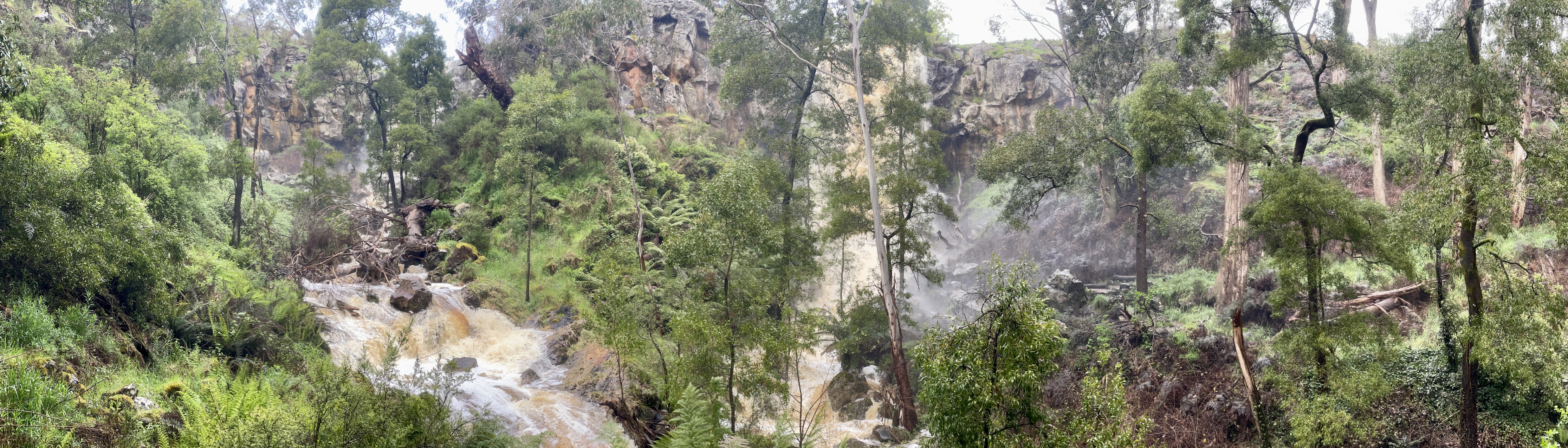
After another big dump of rain Sailors Falls were pumping this morning.  

Sailors Falls.


Crossing Sailors Creek was... interesting this morning 😮


Once on the west side of the creek I had some easier walking...

... although it was rarely dry. 


Dropping back down to there creek again. 

I followed an old water race up stream to the next crossing.

Yeah...nah, I think I'll give this one a miss this morning. 

Retracing my way way back to the start. At least these runners bleed the water out quickly!

Back at Sailors Falls.

Now I just have to get across that again.


The Dirt.
Well, according to Alltrails I walked around 3.4 kilometres and climbed about 104 metres on what would normally be a very easy walk - having said that I'd stay away from this walk after one of our frequent once in a hundred year rain fall events as the crossings were both very dodgy this morning. The second downstream crossing wasn't worth the risk this morning so I actually retraced most of the walk. Now having said that, these falls are definitely best seen after good rain so it is best to visit after some rain. The tracks on this one are signposted fairly well. I used Alltrails for navigation this morning.

Relevant Posts.

YouTube Video.


Wednesday, March 29, 2023

Tramway Falls Walk, Tanjil State Forest - October 2022


So, I mentioned a couple of posts ago about the rational for me starting to swing over to YouTube and spend a little less time working on each blog post. One of the side benefits of this is that I've been out doing quite a lot of walking recently which has resulted in a huge backlog of posts that I'm sitting on. I'm thinking that from now on I will actually be publishing more posts than I have before, the downside being that the posts could be a little spasmodic. If anyone want's to be sure that they catch my latest mild adventure then the easiest way would be to subscribe to the YouTube channel and hit the bell icon - YouTube will then send an alert that I've posted. The blog posts will closely follow the relevant YouTube posts. 

Cheers
Kevin


Tanjil Bren was a pretty quiet spot this morning.

Leaving Tanjil Bren required a bit of navigation. 

Climbing away from Tanjil Bren into the hills I got a few long range views... of the nearby logging coupes😞

The 4wd track was closed off to vehicles. 


Tramway Falls from above - to view the falls  from below would of required a little too much scrub bashing and scrambling for me this morning!

The creek above the falls is very pretty as well. 

After leaving the falls I followed this recently bull dozed track for awhile.

Dropping back down towards Tanjil Bren I got some views east. 


When I could ignore the fact that I was pretty well surrounded by logging couple the forest was pretty impressive. 

The Thomson Dam is out in that direction - it was expected to spill for the first time in decades in the next few days. 


I'm almost down at Tanjil Brem again.

The Dirt.
According to Alltrails I walked around 12.4 kilometres and climbed 493 metres on what I'd call an easy-medium grade walk. This walk is all on tracks although neither the walk or the falls aren't actually signposted in any way so you'll need some kind of a map. This walk goes very close to a lot of logging coupes in spots so I'm thinking that it maybe subject to closures occasionally. I used my Alltrails App today for navigation.

Relevant Posts.


YouTube Video.


Sunday, March 26, 2023

Discovery & Lawsons Falls Walk, Bunyip State Park - October 2022


Lawson Falls.

The walk starts from the Lawson Falls Picnic Area.


My day started off with a bit of a road bash.

Climbing up to the walks high piont.

Dropping down towards Lawson Creek.

Early morning in Bunyip State Park.

Lawson Falls.

Lawson Falls.

Down stream of the falls the single track walking continued.

Crossing Lawson Creek down stream of the falls.

Lawson Falls walking track.

Lawson Creek.

The Dirt.
According to my Alltrails App I walked around 5.4 kilometres and climbed about 244 metres on this easy walk. I did the walk in a clock wise direction this morning, the theory being to get most of the road walking and climbing out of the way first up and leave the waterfall and the single track until the back half of the walk - and that's how things turned out. I'm thinking that with this place being a state park then a visit early in the morning or on a weekday is optimul to aviod the trail bikes and 4wd's. I found this walk on Alltrails and used their map.

Relevant Posts.

YouTube Video.


Thursday, March 23, 2023

Kings Falls Circuit Walk, Arthurs Seat State Park - October 2022

The Cherry Ballarts were looking good this afternoon.

Walking this loop clockwise maent that we arrived at the Kings Falls Lookout fairly quickly - the view here is best seen after good rains.

Nice easy walking as Sam and I made our way around to the top of the falls.

Kings Falls Track.

Late afternoon light in Arthurs Seat State Park.

The lookout at the top of the falls gives a glimpse of the falls...

... and a good view west down the valley towards Port Phillip Bay.

The second half of the stroll featured a fair bit of boardwalk.

I roped Sam into this walk with me.


Climbing back up to the ute. 


The Dirt.
According to Alltrails we walked around 1.2 kilometres and climbed about 45 metres on this very easy stroll. This little walk is all along well signposted and engineered tracks so the walking is pretty good. Kings Falls themselves can be a little underwhelming - definitely time a visit for after some good rain.
I used my Alltrails App for this stroll although the walk doesn't feature on their website so I was just utilising their topo maps really.

Relevant Posts.

YouTube Video.


Pelion Hut to Mt Ossa return, Overland Track - April 2010

Mt Oakleigh from the Pelion Hut heli pad. I think the mountain just visible in the mist in the distance is Cradle Mountain... ... the flat t...