 |
| Red Jacket |
Not that I knew it when I woke up on day 5 of my AAWT adventure but today would provide me with another first on the walk, yes it turned out that today would be my first day without any kind of precipitation on the walk so far, definitely a good thing in my books. It wasn’t just the sunny skies that had me in a good mood this morning, I was also picking up my first food drop tonight. I was planning on camping at the food drop so had placed a couple of treats in the boxes, so I had a bit to look forward to today. With the Feral mojo at a high point I was packed up and on my way by around 8am, something almost unheard of for me.
 |
| Leaving Blue Jacket this morning I almost immediately passed this old quarry. |
Like yesterday, on paper today looked a little uninspiring, road bash followed by scrub bash followed by a loooong road bash, the reality on the ground today though was a lot better than I had feared. First up I continued north west up Violet Town Track bedside the Jordan River, with the vehicle track still closed to vehicles for winter and the dappled sunlight filtering through the trees the fairly level track warmed me up nicely. Nearing the site of another old mining settlement, Red Jacket, I took a couple of short side trips to check out some of the historical remains. First I climbed up to the site of the old Red Jacket school, this spot is remote enough now so I can only imagine what it was like to bring up a family here at the start of the last century. There isn’t a lot left of the old school now, a rusting boiler and some stone footings in a clearing on a terrace on the steep hillside being about the extent of it. Returning to Violet Town Track and my pack I continued on a couple of minutes towards Red Jacket before once again taking a short side trip, this time up to the old cemetery. I’m not sure who is responsible for the maintenance here but, while they are fighting a losing battle against the blackberries along the river banks they are doing a very good job of maintaining these historical sites, the short side trips are sign posted and feature information boards, the short tracks themselves are clear of scrub and easy to follow.
 |
My responsible shooter mates had taken care of this pesky marker on Violet Town Track with their .22, god bless them.
 |
Early morning on Violet Town Track.
 |
I'm just arriving at Red Jacket, the old camping area for the AAWT on the Jordan River use to be the flat spot beside the bridge.
 |
The Red Jacket School Site, there isn't a lot left now.
 |
| Red Jacket Cemetery is worth checking out if you are passing through. |
|
|
|
|
After enjoying poking around these interesting sites for awhile it was time to start the days hard work, after crossing the Jordan River at Red Jacket and re-filling my water bottles to get me through the rest of the day I reluctantly shouldered my pack and started up a climb that would basically last for the rest of the day. Climbing up Victor Spur Track I was on the lookout for what John Chapman describes as a ‘poorly defined foot track’, now Mr Chapman might be the king of understatement I think, when using his notes I have to adjust them by the Fat Feral Factor, if Mr Chapman describes something as steep then in my Feral world that’ll mean I’ll probably need hands and legs to get up it, if Mr Chapman suggests that water can be hard to find then in my Feral world that means that I’ll be descending into a blackberry choked valley for hours to find a trickle of turgid water, and likewise if Mr Chapman suggests that the pad is scrubby or poorly defined then chances are I’ll soon be pushing through a wall of impenetrable scrub. So with all that in mind I was mildly surprised to find a well sign posted and reasonably clear track leaving Victor Spur Track and heading up the spur.
 |
After crossing the Jordan River the AAWT starts a long climb.
 |
After twenty metres or so following Victor Spur Track the AAWT heads bush up the spur.
 |
| The dry and open forest made for very nice walking. |
|
|
It wasn’t all sweetness and light though, my notes said that the AAWT heads up the crest of Victor Spur but the benched track that I was following was starting to sidle the spur a little, it’s always hard to leave a well defined track to head off on a speculative scrub bash but with the crest of Victor Spur getting further away I eventually decided that it was time. Climbing up towards the crest of the spur though the dry, fairly open forest wasn’t too bad though and nearing the crest I once again came across some AAWT markers, there was even a fairly good pad making it’s way up the crest, makes you wonder how I missed it really…..? So while I’d braced myself for a fairly hard walk up Victor Spur the reality was that it was pretty good, in hindsight it was actually the best walking for the day. Not only did the open forest make the walking easy even if the faint pad faded away, but the open forest even allowed for some nice views through the trees of the surrounding country, something that is always good when I’m slogging my way up hill.
 |
Once located on the crest of Victor Spur there is a bit of a pad to follow.
 |
As is usual there are a variety of clues around to reassure you that you are still on the AAWT.
 |
The climb up Victor Spur had me heading more or less east into the morning sun so the photos suffered a little.
 |
I was starting to wonder if I'd ever escape the Thomson River Dam, it felt like I'd been walking around it forever.
 |
| At least there was some good reasons to stop on the solid climb up Victor Spur. |
|
|
|
|
The climb up Victor Spur relents a little at one stage, the AAWT passing a deep, open mine shaft just to the south of the pad, something to be a bit careful of. Following the varied AAWT markers I continued up the spur, once again climbing solidly this time until I popped out of the scrub back onto Victor Spur Track, you can follow this fire track all the way up from the Jordan River but it’s a longer walk and with the crest of Victor Spur making for very nice walking my Feral recommendation would be to give the fire track a miss and take the walking track. Back on the wide Victor Spur Track I continued on my climb up towards Mt Victor, well for about five minutes anyway. Arriving at a nice grassy opening with views stretching south all the way to the Baw Baw Plateau I decided that this would be as good as anywhere for an early lunch and a bit of gear drying. Sitting on the grassy side of Victor Spur Track under the cobalt blue sky in the sun, life in my Feral world was pretty sweet, while I would of preferred to be dining on something a little more appetising than vita wheats and peanut butter washed down with lukewarm water, the view more than compensated for my culinary limitations today.
 |
This unfenced old mine shaft is just to the south of the pad up Victor Spur.

 |
| Out of the scrub and back on Victor Spur Track it was time for some drying action... and my first lunch. |
|
 |
| Baw Baw Plateau in the distance. |
|
|
Suitably refreshed after my first lunch I once again set off up Victor Spur Track, climbing a bit more gently now towards Mt Victor. The AAWT doesn’t actually go over the top of Mt Victor, instead it sidles it’s western shoulder, with the thickly forested summit not offering much in the way of views I gave the summit a miss today and stayed on the AAWT as it dropped a little to meet the Matlock Walhalla Road. This lonely dirt road is generally open all year and is normally do-able in a 2wd vehicle so it makes it a popular spot to access the AAWT. While Matlock Walhalla Road is open all year it’s hardly a busy thoroughfare, on the three kilometres that the AAWT shares with the road I didn’t see a vehicle today. I’ve driven this road many times over the years but I’ve never walked it before so it was interesting to see how much more detail I noticed on foot, the forest giving me some views through to the surrounding ranges, something that I hadn’t noticed when driving the narrow winding road. Passing an old road workers hut that is now derelict but in AAWT folklore apparently use to provide rough shelter to walkers and then an historical marker to the survey party that marked out the road, I arrived at Mt Selma Road.
 |
The still closed Victor Spur Track made for reasonably pleasant walking on this beautiful day.
 |
After arriving at the more substantial Matlock Walhalla Road the AAWT follows it east for around three kilometres.
 |
The view north off the Matlock Walhalla Road, I don't notice this stuff when I drive along here generally as I'm normally to busy concentrating on the road.
 |
The old road workers hut beside Matlock Walhalla Road, over the years some AAWT walkers have used this hut as a rough shelter......no more though.
 |
 |
| An historical marker beside Matlock Walhalla Road, if there is anyone under 60 who actually browses my blog then CRB stands for Country Roads Board. |
|
|
|
|
|
Mt Selma Road marked the spot that I entered the Goulburn State Forest and left the Thomson Catchment, it also marked the spot that I started to pass through forest that had been severely torched in the bushfires back in the 2000’s, the hills now being largely crowned with the stubble like skeletons of dead Snow Gums. Wandering up the dirt Mt Selma Road the walking was reasonably pleasant, no doubt helped by the weather being almost perfect for walking. Half an hour or so after starting up Mt Selma Road I arrived at the historical site of Fiddlers Green, this is the site of another old mining settlement but as far as the AAWT goes it’s normally the spot that walkers place a food drop and spend a night on the their walk from the Jordan River to the Black River. I’d decided to place my food drop a bit further along the AAWT though, reasoning that this spot is very popular and a bit to close to the road for my liking, wandering around Fiddlers Green counting the 12 gauge shotgun cartridges on the ground I was pretty happy with my decision.
 |
I'm about to head up Mt Selma Road here to the left.
 |
The mountains were now crowned in dead Snow Gum stubble.
 |
Fiddlers Green is the site of another historical village.
 |
| I think I made a good call camping on Champion Spur rather than Fiddlers Green today. |
|
|
|
Leaving Fiddlers Green I continued on climbing up Mt Selma Road towards Mt Singleton. After climbing for most of the day it was pretty weary Feral Walker who finally topped out at today’s high point on the flanks of Mt Singleton, not only was I happy because the climbing was now over for the day but turning on my phone I was also happy to see that I had a signal and could get a message out to Sam telling her that all was good. After skirting Mt Singleton the AAWT drops a little before rising again to meet Champion Spur Track. It was a tired and sweaty Feral Walker who shuffled the last few metres down Champion Spur Track to my food drop.
 |
Still climbing up Mt Selma Road, the days walk eventually tops out as Mt Selma Road contours around just below the summit of Mt Singleton.
 |
Leaving Mt Selma Road I dropped down Champion Spur Track for a few hundred metres to my food drop. This intersection isn't marked with any AAWT markers currently and the Champion Spur sign post was spun around 90˚ when I place my food drop a couple of weeks prior.
|
|
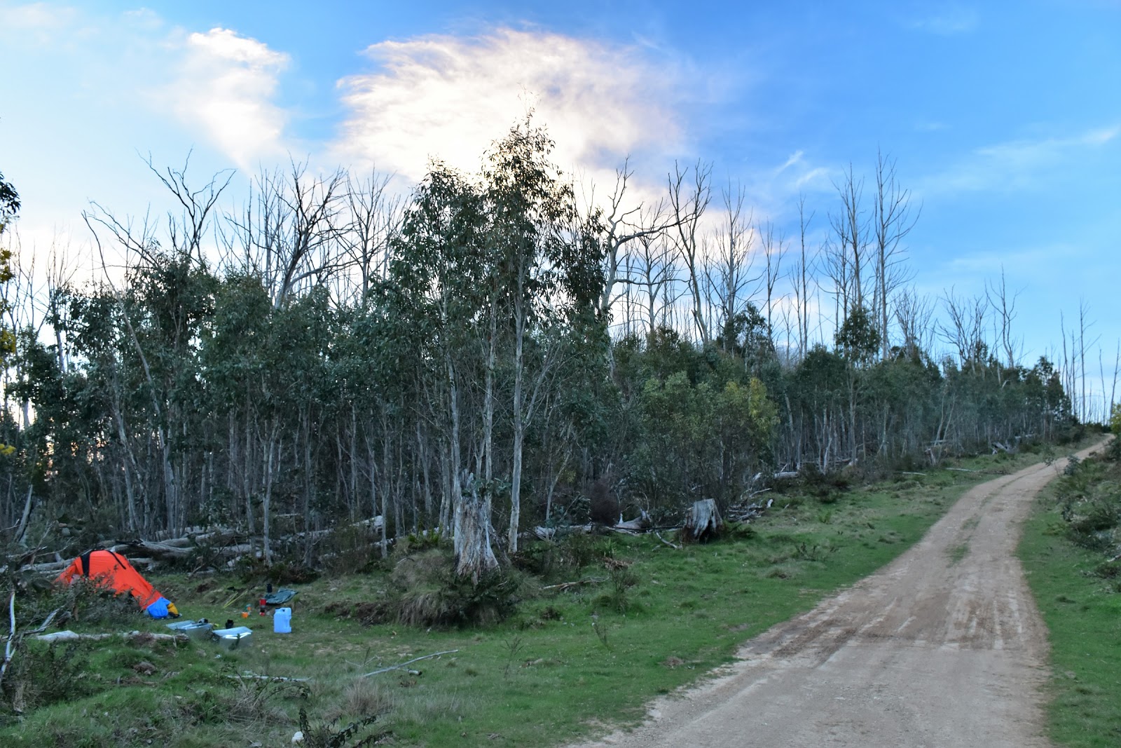
Like I’d mentioned I’d chosen this spot for my food drop because I‘d thought that Fiddlers Green was a little too popular and close to the road and while I was more or less camping on Champion Spur Track here, I was hoping that as it was a 4wd track it would be a lot quieter. Retrieving my food bins from the scrub I set up camp and settled in to enjoy the rest of the day, life was indeed very good! As it turned out camping on Champion Spur proved to be a good decision, not only did I not have any vehicles go past my camp but the extra 4 kilometres that I’d walked on from Fiddlers Green meant that I had 4 less tomorrow to get me to my next camp on the Black River, a good thing considering that my pack would now be the heaviest it would get on the whole AAWT.
 |
I'm happy to see that my food drop is still well hidden and safe.
 |
| My Champion Spur camp. |
|
The Dirt.
I walked 19 kilometres and climbed 1150 metres on this hard days walk. So far on my AAWT journey I’d walked 93 kilometres and climbed 3990 metres. There is no reliable surface water on today’s walk once you leave the Jordan River at Red Jacket. Generally walkers leave some water and a food drop up near Fiddlers Green somewhere, it would be possible to make it from the Jordan River to the Black River over one day, but it would be a very big day….and I’m too old and broken for that now. If not wanting to camp at Fiddlers Green there are a few options once you leave the Thomson Catchment however none of them are what you’d call optimal! Navigation wise there were a couple of issues today, the first one is on the climb up Victor Spur. The AAWT leaves the Victor Spur Firetrack and starts to follow a well benched walking track, the issue is that at some stage it leaves this benched track and starts to head up the crest of the spur. If you miss the spot to start climbing along the crest then just head through the fairly light forest until you hit the crest and you should find some kind of AAWT markers or faint pad, from there on up just stay on the high ground more or less. The other navigational issue is the turn off onto Champion Spur Track, there are no AAWT markers and the sign post was facing the wrong way when I placed my food drop up there, I fixed the sign post but it’ll just take one bogan to spin it around again so keep a eye on the map. Speaking of maps it was Chapman’s notes and maps that got me through the day. I also had Rooftops
Walhalla-Woods Point Adventure Map in case I needed an overview. I managed to get a Telstra mobile signal at the high point on Mt Selma Road near Mt Singleton today.
Relevant Posts.
AAWT Day 1, October 2017.
 |
| I wasn't far from Champion Spur Track but it's a pretty quiet 4wd track and I didn't see anyone the whole time I was camped there. |


No comments:
Post a Comment