 |
| There was a lot of Big Sky Country today. |
After a great nights sleep last night at Four Mile Hut I opened my eyes to sunlight streaming through the window this morning, blinking in the bright light I staggered outside to be greeted by a blue sky with hardly a cloud to be seen, sweet! With the day looking good and the promise of picking up my last food drop in a couple of hours I didn’t linger too long packing up and eating breakfast this morning, I was pulling my pack on and setting of from Four Mile Hut by just after 8am this morning.
 |
| Today looked like it was going to be a pearler of a day. |
After retracing my way back to Tabletop Trail I turned north and resumed trudging my way to Canberra. I was now skirting my way around to the east of the Mt Selwyn Ski Resort, the AAWT intersecting with a few cross country ski trails being the most obvious give-away that the resort was close by. The AAWT is for the most part crossing high plains along this section and in spots the old fire trail gets a little faint as it makes its way across these grassy plains. While I was keeping a close eye on the map as I crossed these plains the walking was generally very good, the open country making progress very easy again, with only wet swampy ground slowing me down occasionally.
 |
Heading back out to re join the AAWT this morning the bush was a riot of colour.
 |
Mt Selwyn Ski Resort
 |
Tabletop Trail was pretty grassy in spots this morning......
 |
.....a bit damp in spots.....
 |
.....and a little faint in other spots.
 |
 |
| The trail had been rooted up by, what I'm guessing is feral pigs in a couple of spots. |
|
|
|
|
|
|
With Tabletop Trail starting to descend down to Kiandra I stopped to text Sam and check out the weather forecast again, unfortunately the forecast hadn’t changed and things were still looking like they were going to get pretty grim in a few days. Actually, in relation to the phone this was the last time that I’d get a signal for many kilometres, the next signal that I picked up would be from the top of Mount Bimberi, although keep in mind that my phone was generally turned off and I’d only try it at likely looking spots. With the historic buildings of Kiandra in view now in the valley below me it was time to set off again.
 |
With Kiandra visible below me I stopped to text Sam and check the forecast, I wouldn't pick up a mobile signal again for a lot of kilometres.
 |
My last food drop on my AAWT walk, sweet!
 |
| I think the NSW Parks people are restoring this old hut. |
|
|
Dropping down fairly steeply I was now looking for the spot were I’d hidden my last food drop, with the valley opening up a bit things were starting to look pretty familiar and I waded into the knee high scrub bordering the track. Glancing at the GPS to check that I was indeed in the right spot I headed for a slightly higher bush, passing someone else’s food drop on the way across, arriving at the likely looking bush I found my last food bin for the AAWT safe and sound, all good! I’d imagined myself making it this far as I’d thought about the AAWT over the years, but it was slightly surreal to realise that now my journey was getting close to its end. Logistics wise everything had gone off without a hitch and from now on it would be largely just up to me and mother nature as to whether I’d make it to Canberra, and I was pretty happy with that.
 |
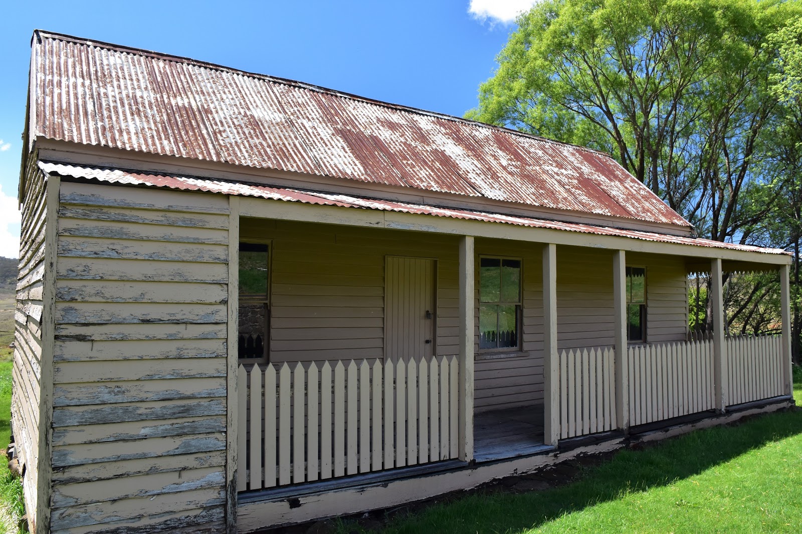
| Kiandra |
After sorting out my remaining supplies I stashed the bin back into it’s bush and shouldered my, now somewhat heavier pack, and set off plodding my way north again. Dropping down towards the Snowy Mountain Highway I walked past a couple of old huts that have been restored by the NSW Parks people, the historic huts now being hired out for people to stay in. Passing some of the old Pollocks Gully Diggings I crossed the highway and meandered my way along the Kiandra Heritage Trail towards the historic Kiandra Court House. With the court house in view on top of a bit of a rise and the Snowy Mountains Highway to my left there were no real navigational issues along here. The heritage walk has a smattering of information boards scattered around and it was an interesting little interlude to my journey reading about the history of this old gold mining settlement.
 |
The old Pollocks Gully Diggings at Kiandra.
|
Arriving at the
Kiandra Court House I dropped my pack in the shade of the veranda for a bit of a break, having a chat to some grey nomads that were having their morning tea at here. With relatively easy access from the Snowy Mountains Highway, Kiandra is a good spot to start or finish a sectional walk on the AAWT I think, with the sections of the AAWT to the north and south being a lot easier than the Victorian sections. After a nice chat it was time to grab my pack and shuffle off again, the AAWT following the highway for a few hundred metres before dropping down Nungar Creek Trail to cross the Eucumbene River. Arriving at a locked gate that kept vehicles off the trail I had the ford of Bullocks Head Creek right in front of me, twenty metres further on I could see the more substantial ford of the Eucumbene River, with the water lapping at the grass on their banks neither of these fords looked easy today. So it was off with the boots, socks and pants and on with the sandals. Wading into Bullocks Head Creek I found that while the water got about mid thigh deep, with the help of my poles the crossing wasn’t too bad. The Eucumbene River was a different story though, the river was flowing over it’s banks in spots and the current looked strong, cautiously wading in, with my poles helping to brace me against the current I eased my way across the fairly wide river, with the freezing water lapping at the top of my thighs I was pretty keen to get back onto dry land but I had to be extremely careful not to lose my footing on the slippery rocks as the current tried to rip my legs out from under me. Needless to say, I made it, but that was my dodgiest water crossing to date on the AAWT, mind you with all the rain around it was hardly surprising I suppose.
 |
The historic Kiandra Court House.
 |
Bullock Head Creek ford with the Eucumbene River in the distance.
 |
Eucumbene River
 |
| The crossing of the Eucumbene River was a little more serious than it appears in this photo I think. |
|
|
|
After drying out in the sun for awhile I pulled on the my boots and set off up Nungar Trail. It was along here that I passed out of the burnt Snowgum forest that I’d been largely walking through since way back near the Victorian border, being surrounded by flourishing mature trees along with the great weather no doubt helping to keep my Feral mojo high. It was also along here that I once again started to encounter large numbers of brumbies again, I’d be treating my water again for awhile now. Nungar Trail was pretty cruisey walking this afternoon as it rose and fell fairly gently as the AAWT crossed a series of very picturesque high plains.
 |
Climbing up Nungar Trail I had one last look back down to Kiandra.
 |
I've finally passed out of the bushfire zone which meant that for the first time since way back near the Victorian border there were a large amount of mature Snowgums about.
 |
I was also back in the horsey country now.
 |
Wild Horse Plain
 |
Chance Creek
|
|
|
|
|
After crossing Chance Creek the track climbed a little, crossed the headwaters of Kiandra Creek, before meeting Alpine Creek Trail and dropping down to a big broad grassy valley, passing by the historic Kiandra Creek Diggings on the way. The only real evidence of the Kiandra Creek Diggings left now days are a few trenches and mullock heaps scattered around but with the grass having reclaimed everything you had to use a bit of imagination here, luckily I’d been walking on my own for the best part of five weeks now so my imagination was in good working order!
 |
Nungar Creek Trail
 |
 |
| The grassy Nungar Trail dropping down to cross the headwaters of Kiandra Creek. |
 |
 |
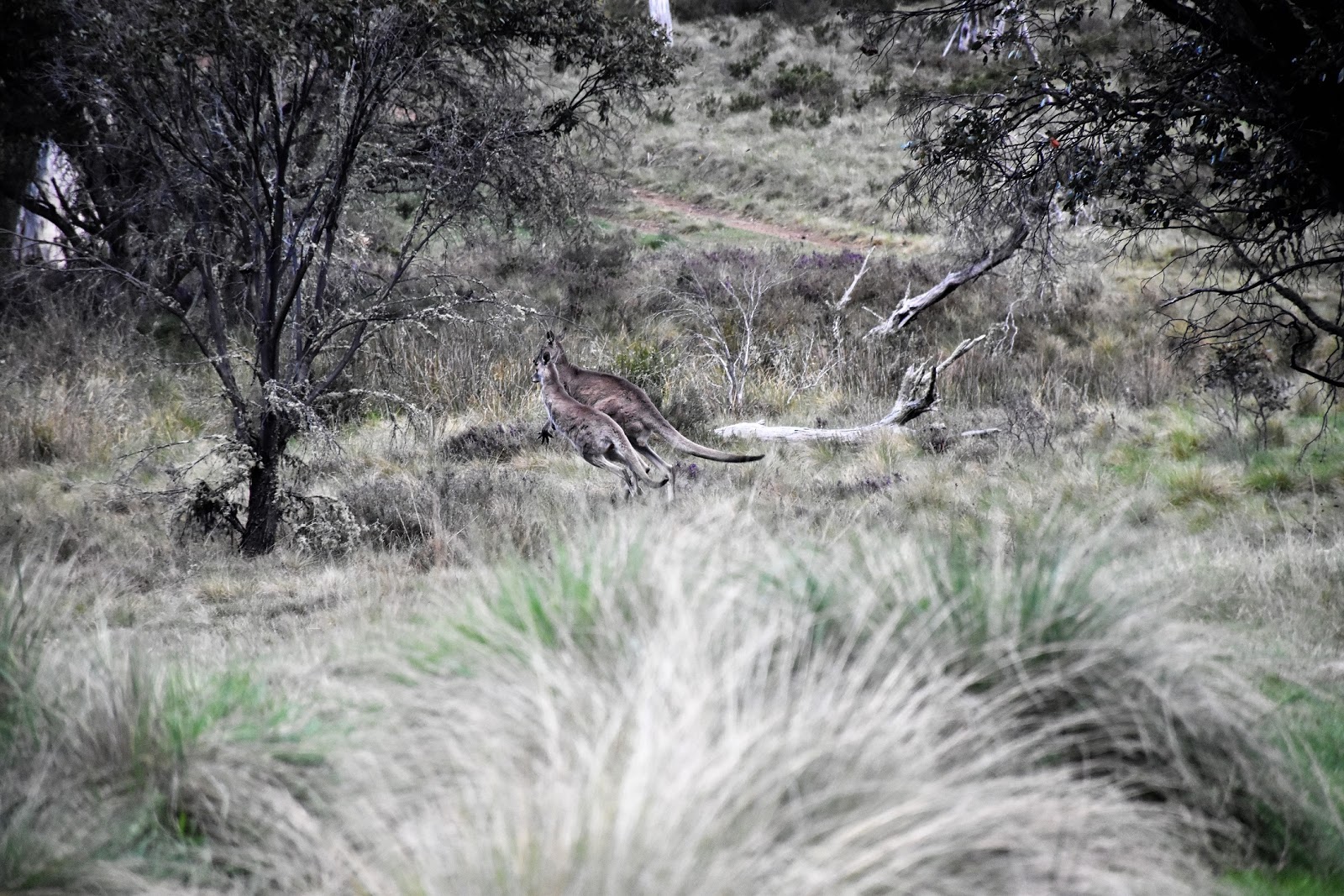
A few of the locals were out and about.
 |
Nungar Trail dropping down towards Kiandra Creek Diggings, that's the valley of Tantangara in the distance, my next objective.
 |
| There is not a lot left of Kiandra Creek Diggings. |
|
|
|
|
|
I was now crossing the wide valley of Tantangara Creek, this spot looked a bit swampy but with the creek being bridged I wasn’t thinking that I’d have too many issues. Arriving at the creek though I could see that all the recent rain had created an unexpected issue, Tantangara Creek had burst it’s banks and while the bridge itself was above the water the surrounds were inundated, with the track appearing to have the deepest water over it. There was hope to get through here with dry boots though, it looked feasible that I might be able to hop across using the tussock grass, although with the tussock grass no doubt being home to a population of snakes it wasn’t an option without risks! Thankfully after a bit judicious boot placement I managed to escape with reasonably dry boots and no close encounter of the reptile kind.
 |
Tantangara Creek wasn't so wide but it was very deep, I had a bridge though.
 |
There was a slight issue though with the bridge.
 |
| Jumping from tussock to tussock I managed to get through with reasonably dry boots. |
|
|
Climbing gently away from Tantangara Creek this afternoon I couldn’t help to cast my mind forward and wonder what my next crossing of Tantangara Creek would have in store for me tomorrow, a crossing where the bridge has long ago been washed away. That was all in the future though as I gently climbed around a low spur, very soon arriving at tonights accommodation of
Witzes Hut. This old hut was built in 1952 utilising some of the remains from the original hut that was built on this site back in 1882. I’d rocked up here by mid afternoon today so I was able to once again kick back and enjoy the last few hours of daylight as I relaxed around the hut, watching the local wildlife come down to the nearby creek for a drink. The distances on the AAWT were certainly coming easier now.
 |
 |
Witzes Hut
 |
| The local wildlife came down to drink from the nearby creek at sunset. |
|
|
The Dirt.
I walked 21 kilometres and climbed 485 metres on today’s walk, I suppose I’d call this a hard day but only really for the distance and maybe the water crossings. So far on my 35 days walking the AAWT I’ve walked 627 kilometres and climbed 25,880 metres. Water, navigation and camping are all pretty straight forward again today, although Tabletop Trail does get a little faint as it crossed the high grassy alpine plains before dropping down to Kiandra. The water crossing were the most concerning thing today, with the Eucumbene River being a little marginal after all the rain (and I’m 6’3” and 120 kg), there is a way around this crossing though (and that of Bullock Head Creek). If you arrive at Kiandra and the flood plains of the Eucumbene River are covered with water then head east back along the Snowy Mountain Highway in the direction of Cooma for a couple of kilometres, cross the Eucumbene River on the highway bridge and then walk the, generally open slopes on the east side of the river, up stream a couple of kilometres to meet Nungar Trail just past the river crossing - it’s a little clunky but you’ll do it with largely dry boots. I got a Telstra mobile signal today just before Tabletop Trail dropped down to Kiandra, I didn’t get a mobile signal near camp tonight at Witzes Hut though. Kiandra is a good spot for a food drop although you’ll probably need to stash your container under a bush, there’s a toilet at Kiandra along with good sealed road access. I used Chapman’s notes and maps today as well as carrying Rooftop’s
Kosciuszko Northern Activities Map Kiandra - Tumut in case I needed an over view.
Relevant Posts.
AAWT, Day 1, October 2017.
AAWT, Previous day, November 2017.
 |
| The view from Witzes Hut this afternoon. I was lucky with the weather today, managing a full day without rain. |
 |
| Bedtime at Witzes Hut. |


No comments:
Post a Comment