 |
| Morgan Beach.....this post is so big it could be the post that breaks blogger! |
I’ve had this Cape Liptrap to Venus Bay walk in the back of my mind since reading Mr Fiasco’s hilarious account of his action packed walk along the coast, way back in the golden age of
Fiasco Blogging. The one thing that has always held me back (apart from apathy) was that the walk involves a reasonable car shuffle and being a fair drive from home I’ve been a bit reluctant to drag Sam all the way down there just to chauffeur me around. With the weather and the tides both looking pretty good I decided this was the day, a quick phone call to the local taxi operator and everything was sorted. The taxi would pick me up at the Venus Bay Surf Club at 9:30 before driving me down to Cape Liptrap, all I had to do then was to walk back to Venus Bay at my leisure, sounds easy enough.
 |
| The rather diminutive Cape Liptrap Lighthouse. |
After squeezing in a couple of hours at work I set the cruise control headed off down the South Gippsland Highway towards Inverloch. Grabbing my now, somewhat traditional hardcore walkers breakfast of Maccas toasties and a coffee on the way, I arrived at the surf club ten minutes in front of the taxi, just enough time for me to pull on my boots and gaiters. Now this stroll has been written up by Mr Tempest as an overnighter and my original plan was to throw my bivy bag into the pack and sleep on the beach somewhere. However a closer look at the map and notes had me thinking that I’d probably easily enough do this walk as a day walk, with my late morning start I was hoping that I’d get a few sunset shots to enliven the beach stroll at the back end of the day, time will tell how that goes.
 |
| That's Wilsons Promontory under that bank of cloud across Waratah Bay. |
Eighty dollars lighter in the wallet I waved goodbye to the taxi at the Cape Liptrap Carpark and wandered down to the lighthouse to check things out, almost standing on a snake about 5 metres from the carpark, oh well at least I was awake now! Looking into the sun across Waratah Bay I could quite easily make out Wilsons Promontory jutting out into Bass Strait, it’s higher peaks jagging the clouds. Turning away from the Prom I took the obligatory start photo at the bonsai like lighthouse and then retraced my steps back up to the carpark. I was now looking for a walking track that burrows into the thick coastal scrub and from what I could ascertain it wasn’t going to be obvious. After a couple of hundred metres I arrived at an obvious gate and track, but according to my notes this wasn’t my ongoing route so I continued on up Cape Liptrap Road for a few more minutes, eventually finding a very old track burrowing into the scrub, yep that’d be my track I’m thinking.
 |
Cape Liptrap
 |
Avoid this track.
 |
A little further along this is the track.
 |
| This would be good walking if you are 3'6" but not so good if you are 6'3" like your Feral correspondent. |
|
|
|
Now when I say burrowing I do mean burrowing, at least initially the track was more suitable for Wombats rather than a somewhat rotund bushwalker with a dicky back and knees. Thankfully for my back the overgrown path opened up a little after a few minutes and I could stand upright for the most part, the scratchy scrub encroaching the track now my biggest annoyance. Happily I only had around 800 metres of this crap to push through before I’d get to the coast line and arriving at an open area I got my first view down to the small cove that I was aiming for. I had choices here though, my rough track appeared to split with the left fork heading in opposite direction to which I wanted to go, so I went right…..well for about five minutes or so before I reluctantly returned to the indistinct junction and went left. Hours later I would be sitting on a cliff top having a bit of lunch and would actually read my walking notes which clearly said to avoid the track heading off right, yep I’m not overly smart! Now on the correct route my pad started dropping seriously down towards the coast, I even found a couple of pieces of old flagging tape down here which went some way to confirm that I was on the pad and not following a rogue Mountain Goat track.
 |
Head left here...not right like me!
 |
This Tea Tree is very scratchy.
 |
If you look very closely you might notice a bit of flagging tape.
 |
| I've just emerged from that at water level, looks pretty easy from down here doesn't it! |
|
|
|
Eventually the scratchy coastal scrub spat me out on the coast, happy days. All I had to do was to turn right, keep the water on my left and keep truckin’ on and I’d eventually arrive back at Venus Bay, no drama then! This section of the coast was the reason that I’d had to time my walk for a late morning start, with low tide predicted for 12pm I wanted to get up to the sand of Morgan Beach before the water started to rise too much. The first three kilometres or so along the coast had me walking a series of rock shelves interspersed with small pebbly beaches, now that all sounds reasonable enough except that the rock shelves largely consisted of slopping, jagged rocks and when I arrived at the beaches the large pebbles made for only marginally easier walking. Still progress towards Venus Bay was still being made and to be really straight, I was loving this walking, a situation no doubt helped by the fact it was a pearler of a day with not a cloud in the sky and a temperature in the high 20˚.
 |
Walking these tilted rock shelves was pretty slow going.
 |
I'd managed to jag a pearler of a day for this stroll.
 |
Early on I passed a freshwater spring tricking down over the rocks.
 |
Those white specks out near the horizon are a large flock of feeding water birds (maybe I shouldn't have dropped the resolution so much).
 |
The geology of Cape Liptrap is pretty special.
 |
| These steep pebble beaches were only marginally easier walking than the tilted rock shelves. |
|
|
|
|
|
After resting in a large sea cave for awhile I continued my northwards journey, the jagged rocks and beaches getting a little easier the further from the cape that I walked. After rounding one last rocky headland the golden sand of Morgan Beach was now in front of me. Striding out onto the hard sand it would be hard to imagine a more idyllic spot, turquoise water lapping at a deserted golden sand beach on a warm and beautiful day, it took all my will power not to strip off and jump in, the one thing that held me back a little though was that I still had a very long way to go yet and it was already after midday. I was now meandering my way up Morgan Beach along the sand towards Morgan Bluff, the beach not only giving me my first really easy walking for the day of any length but also some nice views of the approaching cliffs, my next obstacle.
 |
With the day warming up a fair bit I was glad to have a bit of a break out of the sun in this sea cave.
 |
Looking back towards the cape.
 |
 |
My first view ahead to Morgans Beach.
 |
Have I mentioned the amazing geology?
 |
 |
 |
The sand of Morgans Beach was a lot closer now.
 |
 |
| I've just hit the sand of Morgans Beach and I'm pretty happy to be off the rocks for awhile. |
|
|
|
|
|
|
|
|
|
After crossing Morgan Creek (and noting that it was still flowing well at the end of a very dry spell) I left the beach just before I reached the cliff line, climbing very steeply up a soft dune to gain the cliff tops. I was now going to be tracking along the cliff tops for the next 2.5 kilometres and this promised to be pretty rough walking. I think when Mr Tempest wrote up this walk there was talk of Parks Vic formalising a track through here but I don’t think it ever actually materialised, there is a rough pad in spots but inevitably as soon as you start walking it the pad disappears into an almost impenetrable wall of scratchy coastal scrub. This is the section of the walk that gave Mr Fiasco the hardest time when he pushed through, although he was wearing sandals…with socks! While the walking is pretty rough pushing through the scrub on the jagged limestone cliff tops, the views make up for any hardship in my opinion, this wild section of coastline is stunningly beautiful a situation no doubt enhanced by today's great weather.
 |
I was now heading towards Morgan Bluff at the far end of the beach.
 |
Morgan Beach
 |
Morgan Creek
 |
 |
| Reaching Morgan Bluff I climbed up to the cliff tops. |
|
|
|
|
Picking my way along the cliff tops I stayed as close as possible to the edge, mainly to avoid the worst of the scrub but the views weren’t bad either.The good news was that a few hundred metres after climbing up from Morgans Beach the scrub thinned out a bit and the walking got a little easier, there were still belts of scrub to push through and the limestone was still rough under foot but it was definitely getting a bit easier the further north I progressed. In theory the coastline at sea level is not passable below the cliffs but from my very limited Feral observations it looked to me like it could be worth having a go at this section at low tide, although you’d want to make it through as there would be no easy way of climbing the cliffs along the way, I can see an exploratory Feral walk here some day in the future!
 |
The cliff tops featured a lot of fractured limestone.
 |
 |
The cliff tops also had a few belts of this scratchy coastal scrub to push through.
 |
The fractured coastline looked like it might almost be do-able at low tide.
|
|
|
|
Initially I was passing above a few idyllic sandy coves but as I headed further north along the limestone cliff tops the coastline changed to more fractured rock, with a few large rock stacks out to sea. I was actually aiming for a rock stack called Arch Rock, while not actually having an arch this rock stack marked the spot that my cliff top ramble would come to an end and I’d descend to the beach, which I’d then follow for the rest of the day. With Arch Rock being easily the largest rock stack off shore I was able to gauge my progress by my proximity to it, so at least I knew that there was light at the end of the tunnel as far as the rough slow walking went anyway.
 |
 |
Cape Liptrap Coastal Park occupies a fairly thin strip of land.
 |
 |
 |
 |
The further north along the cliff tops I went the easier (relatively) the walking became.
|
|
|
|
|
|
After passing Arch Rock I did indeed start to drop down to the sand, after a couple of goes I found a steep gully that would get me off the tops and onto the sand for some easy walking. By the time I reached the sand it was already close to 3pm and I still had about 17 kilometres to go before I’d get back to Venus Bay, however with the sand generally being reasonably good to walk on and no real navigational issues I wasn’t too worried, if worst came to worst it would be easy enough to finish off this stroll in the dark. After a quick drink and a couple of photos I started my long beach march north, the good news this afternoon was that I had the breeze at my back but the bad news was I had the hot afternoon sun in my face, such is life I suppose!
 |
There are a few rock stacks along this bit of the coast.
 |
I'm about to drop to the sand again, well once I can find a safe gully.
 |
Looking back towards Arch Rock, yeah I know, there is no arch.
 |
| My immediate future involved a lot of beach walking. |
|
|
|
It was all action on this first section of beach walking (well relatively speaking) in quick succession I crossed Ten Mile Creek (which was still flowing well), Rocky Point (my last shade until Venus Bay) and then the turn off to Five Mile Camp. After passing the Five Mile Camp turnoff the highlights thinned out a bit though, I was now just chewing up the kilometres, a task made a little harder as I was now walking the sand at the top of the tide. This beach is normally fairly good walking but being forced high up towards the dunes and having to take evasive action as the occasional larger wave swept up, combined with me now being a bit tired meant that I was feeling every kilometre this afternoon.
 |
Ten Mile Creek had a good flow in it today.
 |
Things were looking a lot more arid now.
 |
The tilted rocks of Rocky Point.
 |
Bass Strait was looking it's usual wild self this afternoon.
 |
Resting for awhile in the last shade until Venus Bay, still around 15 kilometres and quite a few hours away.
 |
The wind turbine poking over the dunes is the tell that marks the spot to leave the beach if you are heading to the Five Mile Camp.
 |
| Looking north from near Five Mile Camp, at least the wind was at my back. |
|
|
|
|
|
|
Trudging along gazing into the setting sun the main interest now was the changing colours as the low sun lit up the dunes backing the beach, well that and the ever crashing surf washing onto the sand. Just as the sun finally started its final descent into the waters of Bass Strait I met my first footsteps in the sand, hey, hey I was close now! Trudging on (and it was a bit of a trudge now) it was only another twenty minutes until I arrived at the beach exit to the Venus Bay Surf Club, a lone streetlight shining brightly in the gloom making it impossible to miss. After stopping at the carpark lookout to get one last photo for the day I wandered the last few metres up to the carpark above the surf club and, with some relief, took the pack off for the last time today. Climbing into the welcoming drivers seat I settled in for the two hour drive home, arriving just after 10pm after what had been a very solid day but also very rewarding day.
 |
The highlight of this section was finding the Fiasco log to park my arse on for awhile.
 |
High tide walking.....and you think I'm exaggerating when I say that I'm meandering!
 |
Walking into the setting sun.
 |
The low sun did have it's advantages when it came to my photographs though.
 |
 |
| The solo walker self portrait. |
|
|
|
|
|
The Dirt.
I walked around 25 kilometres today and climbed about 250 metres on this hard stroll. When I say hard then I mean hard, this walk is typically done over two days in which case it would probably be a medium grade stroll I suppose. There are some very rough pads at the Cape Liptrap end of this walk and the coastal scrub is particularly tough and scratchy, once down at sea level the rock platforms also make for pretty rough walking. The limestone cliffs around The Arch also make for fairly slow walking. When I went through on this walk it was early March and we and only had about 1mm of rain in the last 6 weeks, so it was interesting that both Morgan Creek and Ten Mile Creek had good flows of water in them, especially considering their rather limited catchments, although with both flowing off farmland it would pay to treat anything you collect. The beach sections are all straight forward although it was a bit of a slog this afternoon at high tide. I used the Parks Vic online free stuff with Glen Tempest’s notes out of his Weekend Walks Around Melbourne book which was all I really needed. Mr Tempest has also written up the Cape Liptrap section of the stroll as a day walk in his Daywalks Around Victoria book as well. The taxi from Venus Bay to Cape Liptrap cost me $80 after the call centre where I booked it quoted me an approximate cost of $42 so keep that in mind!
Relevant Posts.
Wonthaggi Circuit Walk, Wonthaggi Heathland & Coastal Reserve, 2017.
George Bass Coastal Walk, 2016.
Tidal River to Roaring Meg, Southern Circuit, Wilsons Promontory National Park, 2017.
 |
| My cunning plan to be walking the beach at sunset paid off today. |
 |
| Cape Liptrap has disappeared into the evening gloom now. |
 |
| Now regular readers may know of some of my sagas with my GPS, it has a habit of heading off on tangents even if I'm not moving. Here it has me back tracking in a straight line out into Bass Strait. Now I do realise that i wasn't half a kilometre off the beach with the sharks so there is no danger of getting lost, but it does make any distance or altitude stats that I get fairly meaningless, oddly enough this is my second Garmin GPS and the last one did exactly the same thing....maybe it's my tin foil hat? |
 |
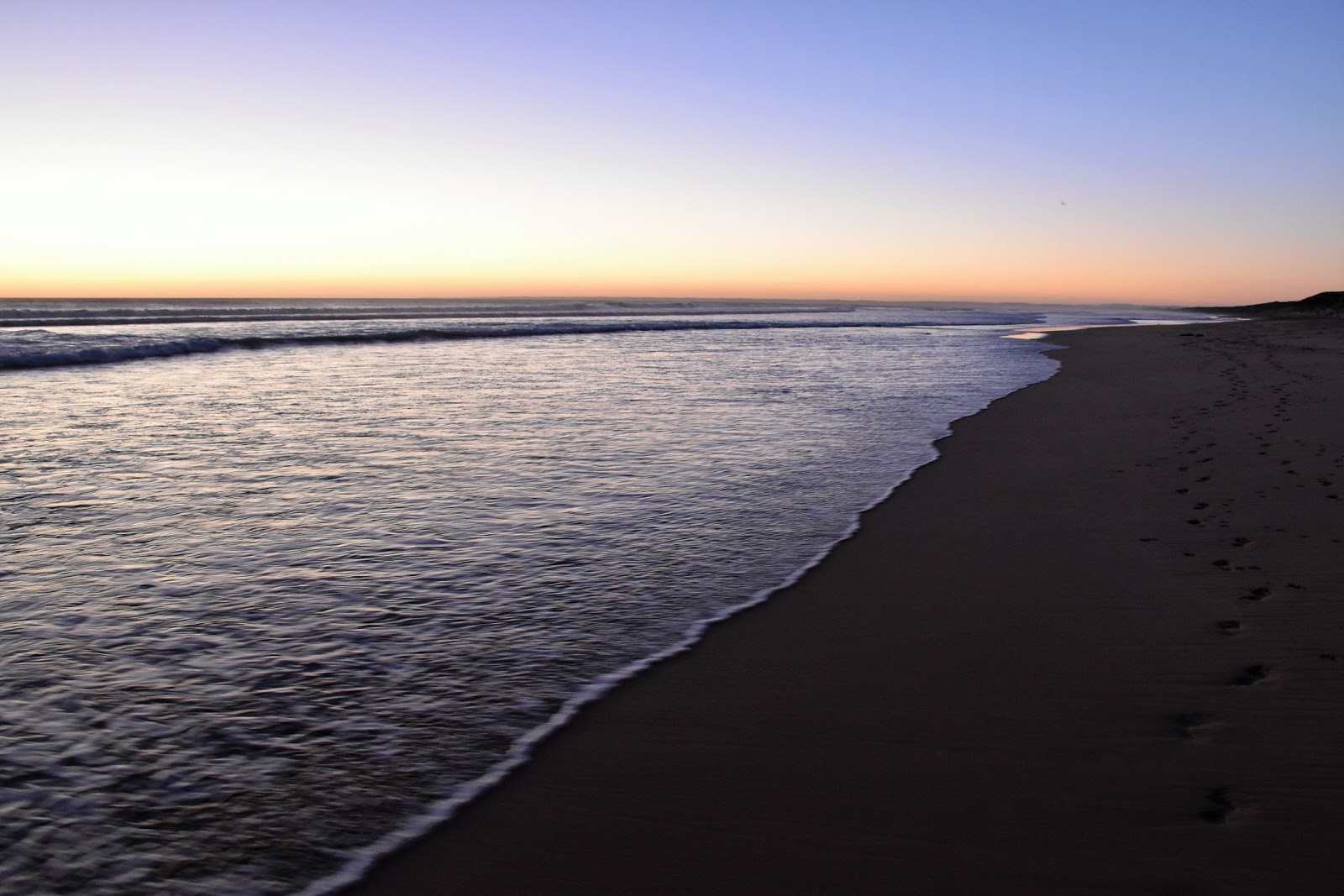
| I've just noticed some extra foot prints in the sand, can't be far to go now. |
 |
| The beach exit to the Venus Bay Surf Club, the street light is the give away. |
 |
| One last look out over Bass Strait from the lookout near the carpark....yeah it was getting pretty dark by now. |


Thanks for this description of the walk. Hoping to do it soon and much appreciate the details you’ve included
ReplyDeleteNo worries... I'm glad it helped.
Delete