Sunday, November 12, 2017

Barrk Sandstone Walk, Kakadu National Park - May 2004

On our top end trip back in 2004 I had a couple of days up my sleeve before meeting Sam in Darwin, so what to do? Not too keen to be sitting around Darwin on my own I decided that I'd head out to Kakadu for a couple of days, after a day spent lazing in the Gunlom infinity pool I decided that I'd better get out and do some walking. My walk of choice was the Barrk Sandstone Walk which basically circumnavigates Nourlangie Rock, visiting the less well known Nanguluwur Gallery area on the way. So, after a restful night in Jabiru I headed down to the Nourlangie Rock Car Park and pulled on the boots.
They don't call this walk the Barrk Sandstone Walk for no reason.
If you think this post is a little on the anaemic side it's because the blog wasn't even a twinkle in my eye when I did the walk, hence I didn't take a lot of photos. Setting off it's only a couple of minutes until I got to the first highlight, the Anbangbang Gallery. This is a superb indigenous art gallery, one that I've visited at least five times over the years, makes you wonder why I didn't take a photo really? After enjoying the art, not to mention the cool breeze and the shade, I continued on up past Gunwarddehwarde Lookout leaving the main tourist track shortly afterwards I followed a rough bushwalking pad up to a waterfall. This place flows nicely in the wet but in early May there was just enough water trickling down for me to quench my thirst.
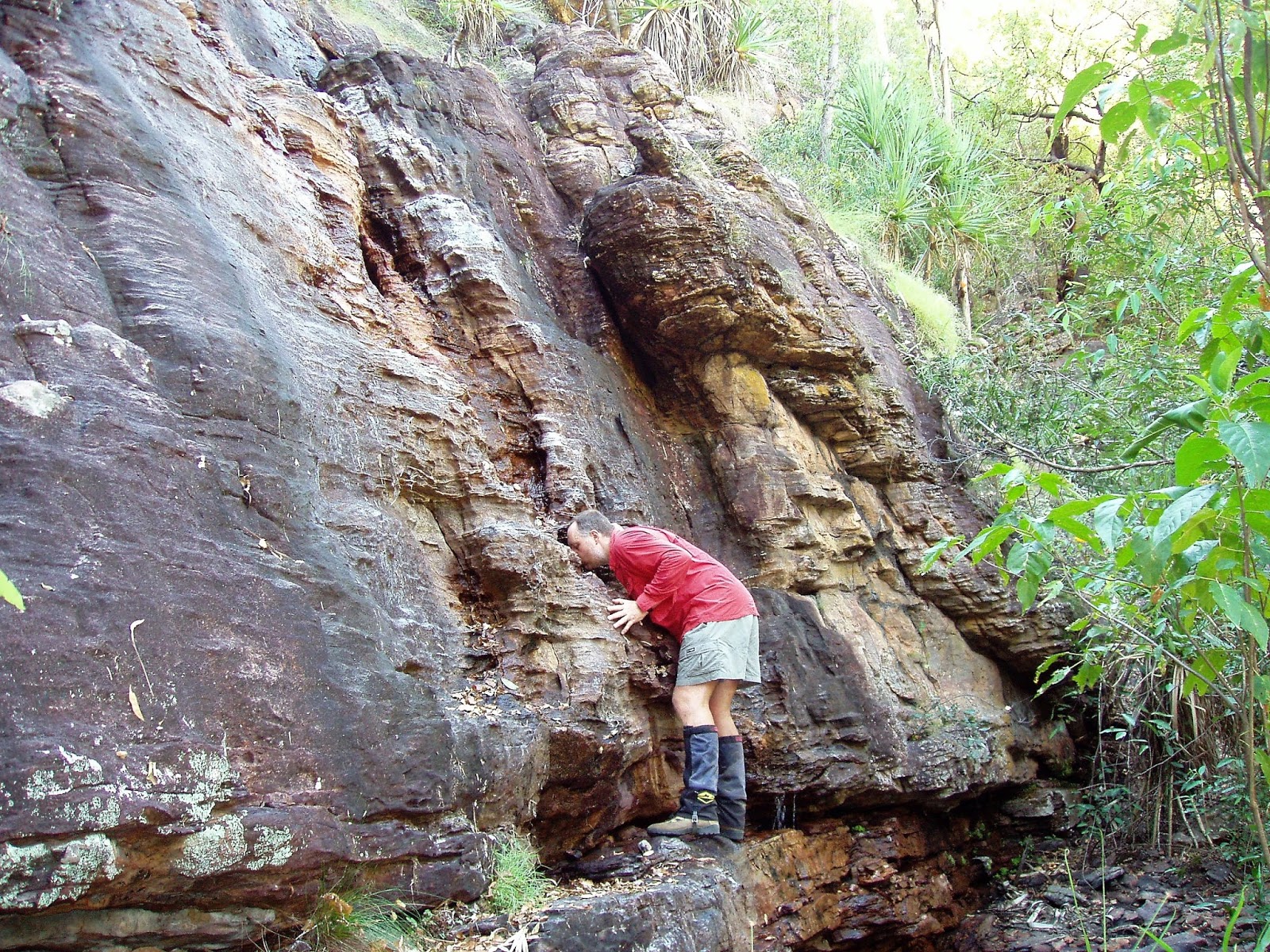
This waterfall only really flows good in the wet, there was still enough water to have a drink today though.
It pays to keep an eye out fort track markers as the route weaves its way through a labyrinth of sandstone turrets.
Leaving the waterfall the track climbed up steeply until I popped out on a kind of plateau above the waterfall. The view from this spot is one of the best on the walk as it looks down over the Kakadu flood plains. From here on the track twists and turns as it makes its way firstly through a labyrinth of sandstone pillars and rocks, the good news today was that the route was fairly straight forward as the high grass that grows during the wet season had largely been flattened by the Knock 'Em Down storms. I've been through here in the middle of the wet and it's a vastly harder walk. Eventually I started descending a rocky gully back down to the low country and started tracking along with the escarpment now on my left as I headed towards Nanguluwur Gallery. This gallery is less well known than the Anbangbang Gallery on the other side of the rocky complex but, but maybe because of that it's a great spot to sit a savour the art for awhile, and at least back in the day more often than not you'd be on your own.
Looking out over the Kakadu floodplains.
After resting at the gallery for awhile I once again set off towards the Troopie. The route now climbs back up onto the rock, eventually topping out in a spot that not only gave me a great view down to the flood plains but also of the massive cliffs that buttress Nourlangie Rock. I now dropped down through a damper area, this section of the track through here is a bit of a handful in the wet season, with two metre high grass and boggy ground. With the wet season over and done with the track today wasn't too bad and soon enough I noticed the access road through the trees which signalled my imminent arrival back at the car park.
Nanguluwur Gallery features a large selection of X-Ray art.
Nourlangie Rock
The Dirt.
Not only was this walk way before the blog but it was also way before I stared to use a GPS so I'll have to give you the stats from my notes. According to my notes the walk is 12 kilometres long, altitude gain isn't listed but I'd guess it at around 400 metres. I have two sets of notes for this walk with one rating it as a medium grade and the other a hard grade, I'd go with medium in the dry season. Speaking of notes this walk is written up by the Daly's in Take A Walk In Northern Territory's National Parks as well as Lonely Planet's Walking In Australia. This is by far the longest marked trail in Kakadu, all the other marked routes are on the very short side. It is very possible to walk off track in Kakadu but there are a lot of hoops that you have to jump through to get a permit, I've always found it all a bit daunting trying to line up all the ducks, especially from thousands of kilometres away in Melbourne, I think my off track epics in Kakadu will have to wait until I retire unfortunately.
Relevant Posts.


Wednesday, November 8, 2017

Mount Hotham, AAWT - November 2017

Mount Feathertop
My seemingly never ending Australian Alps Walking Track walk still has me inching my way north like a sloth on valium. Last weekend was a bit of a milestone for me though, yep I shuffled my way into Mount Hotham. The quiet (in summer) resort of Mount Hotham marked the first spot since leaving Walhalla 15 days ago that I could buy a beer....or anything else for that matter. Mount Hotham also was the first spot that Sam was able to come up and meet me on the AAWT so far.
My walk up to Mount Hotham on Friday was an inclement affair.
After an 9 kilometre slog up the Great Alpine Road I was ready for a bit of R+R.
Friday ended well though as I carbo loaded for the next section of my walk.....
I shuffled into town through snow flurries on Friday, with visibility only around a hundred metres I'd given the actual summit of Mount Hotham a miss and headed straight to The General, my accommodation of choice for the next few days. Friday afternoon was taken up drinking at the bar doing my washing, drying out wet gear and carbo loading up in the bar. So by the time Sam rocked up on Saturday morning I figured that we'd better go for a bit of a leg stretch incase I ended up porkier when I get to Canberra than I was when I left Walhalla, not an easy task considering the the amount of climbing I'd been doing recently but one that I was having a good go at.
With Sam arriving on Saturday I thought that we'd better go for a short walk incase I ended up fatter at the end of the AAWT than I was at the start. 
Mount Hotham Beach at the Mount Loch car park.
Mount Loch
With the sun out we decided that the very short amble up to the Mount Hotham summit from the Mount Loch car park should do the trick, at less than two kilometres it still should leave me with some energy reserves to get to Canberra. After parking the ute next to the Mount Hotham Beach (actually that could be another Feral fact?) we checked out the water before deciding that it was a bit cold for a swim today, instead we crossed the Great Alpine Road and climbed up the grassy slopes towards the summit. Reaching the top station of the Summit Chairlift we meandered our way around the dormant, creaking skiing infrastructure and made our way over towards the fire spotters tower that marks the summit.
My first clear view of the mountains that I'd walked through yesterday.
The summit shot.

I'd had my share of crappy weather on the last couple of days before I'd arrived at Mount Hotham so this was the first time that I'd actually seen some of the mountains that I'd been passing over with any clarity, yeah I was able to point out to Sam the spots where it had snowed on me as well as the spots that I'd camped in the rain for the last couple of days. There was only so much excitement that we could take though so eventually we retreated back down and headed to the sanctuary of our room, so I could sort out my gear for the next section of my AAWT walk over to Thredbo (which I'll be shuffling my way towards by the time anyone reads this).
Time to head back down.
Mount Hotham is a pretty quiet spot in the off season.
I had a red robin as a mascot on the last section of my AAWT stroll, every time I stopped on the Barry Mountains section I'd look around and there'd be a little red robin flittering about.
The Dirt.
This barely qualifies as a walk but for what it's worth the amble from the Mount Loch car park to the Mount Hotham summit and back was around two kilometres by the time we meandered around all over the place checking out the snow drifts and the views, with a climb of around 75 metres this definitely falls into the easy category. While I was recovering at Mount Hotham I stayed at The General, this is one of only a handful of places open in the warmer weather up on Mount Hotham and while not a cheap and cheerful option it made for a very comfortable spot to spend a few days off the track.
Relevant Posts.
Dinner Plain to Precipice Plain, Alpine National Park, 2017.
Mount Hotham to Mount Bogong, Alpine National Park, 1992.

The view from our apartment at The General.
I'd already spread my gear far and wide around the apartment by the time Sam arrived so there is no shot of a nice clean apartment unfortunately.
Open plan showering... only close friends should share this apartment;)
My time at Mount Hotham wasn't all blue sky and sun.


Sunday, November 5, 2017

Bullocks Track, Kosciuszko National Park - May 2017

Looking back up the Thredbo Valley.
On our recent trip up to Thredbo I decided to head down the Alpine Way a few kilometres towards Jindabyne and walk  Bullocks Track. This little walk starts off at the top of the Thredbo Diggings Camping Area, before heading off along a shared use track towards Bullock Hut. Making the reasonably short drive down from Thredbo I amused myself watching to see if the ambient temperature display would creep up over 0˚ (yeah, it doesn't take a lot to amuse me!) and while the temperature stubbornly refused to move too far north at least the cobalt blue sky would be good for my photos.

Pulling on my boots and resetting the GPS I headed off along the shared path, this track is a section of a long (ish) distance mountain bike track that runs from Thredbo down to Lake Crackenback. Early this morning though there was no mountain bike traffic on my path, no instead my main hazard this morning was trying not to go arse over on the ice on the track. Leaving Thredbo Diggings the path crosses a section of duck boarding over Bull Creek before climbing gently. Being a shared use track the gradients are very gentle though and the wide track allowed me to check out the beautiful scenery without tripping over my own feet. After stalking a small mob of kangaroos enjoying the weak sun on a small snow plain, my route started a long gentle and slightly convoluted descent down to the Thedbo River.
The shared path down to Bullocks Flat featured a few sections of duck boarding.
The sun was out but it was still bloody cold this morning.
This track would definitely be fun on my mountain bike I think.
At the same time as I reached the grassy banks of the river I also came across a slightly incongruous sight for a bush walk - a massive electrified railway line and bridge spanning the river - yep I'd stumbled onto the Ski Tube. The Ski Tube is a train that transports skiers from here, through the Rams Head Range and up to Perisher in winter. Crossing under the deserted railway line I walked  the final few metres to Bullock Hut, this hut dates back to 1934. Bullocks Hut was the summer residence of a Sydney doctor, a Mr Howard Bullock, and the old hut (there are actually three huts on Bullock Flat) has survived the harsh alpine environment well. 
Looking back up along the Rams Head Range from near Bullocks Flat.
The Ski Tube, you don't see this every day on a walk in the hills in Australia.
Bullocks Hut.
Thredbo River
Looking back towards Bullocks Hut from the Ski Tube bridge.
After poking around the huts and the open grassy flat for awhile I eventually decided that I'd better make a move back to the ute. My route back to Thredbo Diggings more or less followed the course of the Thredbo River all the way back. My return walk was on more of a typical bushwalking track, the pad rising and falling in and out of side gullies, meandering past huge rock outcrops and crossing beautiful little snow plains. Without out doubt though, the highlight of the return walk was the Thredbo River, the crystal clear water cascading down over rapids or languidly slipping by in deep pools. 
Heading back up to Thredbo Diggings the track stayed fairly close to the river.
The track back along the river was more of your typical bushwalking track.

Taking my time I explored some of the small side trips which inevitably deposited me on the bank of the river again, judging by the number of fly fisherman I encountered it's not only Feral bushwalkers that enjoy this country. Whether it be the river or the snow plains, the whole scene is framed by the towering mountains on each side of the Thredbo Valley, it was pretty hard to take a bad photo this morning. By the time the sun was finally starting to warm up the day a bit I was walking back into the Thredbo Diggings Camp, my stroll was at an end. At around two hours this had been a very nice little walk, but now it was time to head back to Thredbo for a lunch date with Sam, hardcore adventuring indeed!

The Dirt.
I walked 5.6 kilometres on this stroll with a moving average of 4 kph, and with 81 metres of climbing then I think you'd have to rate this as an easy walk. I got the notes for this walk out of John and Lyn Daly's book Take A Walk in Kosciuszko National Park and they are all you really need to complete the stroll. The first section of this walk down to Bullocks Flat is a path that is shared with my mountain bike mates so it would pay to be a little alert to their presence, although with no real steep grades and a fairly wide track they shouldn't really present much of a hazard. The walk back along the Thredbo River to Thredbo Diggings would provide plenty of opportunities to catch yourself a trout, or for a cooling dip in summer.
Relevant Posts.

Thredbo Diggings Camp.
The river next to the campsite was very popular with the fly fisherman this morning.


Thursday, November 2, 2017

Cape Byron - January 2007


Bushwalking attire - Byron style!
The last time that we did the whole east coast summer holiday thing was way back in 2007, this road trip actually has turned me off Christmas on the east coast of Australia ever since. Half way home on our road trip down the coast I said to Sam that next Christmas we'd go somewhere with no people. As soon as we arrived home I rang the other woman in my life, Ali my travel agent, and booked us into a trip to Patagonia and Antarctica for the following year. You know what? It was one of the best decisions that I've ever made.


This little stroll saw Sam and I parking the troopie at the eastern end of Byron Bay. After a short beach section we climbed the small headland between Clarkes Beach (the main beach in Byron) and Wategos Beach (what looked like the beach to be seen on in Byron). Descending onto the sand at Wategos Beach I was right at home among the other punters in my special Byron Bay walking attire, the Hawaiian shirt blending in perfectly. After a short stretch on the beautiful beach we climbed again, this time up to Cape Byron. Cape Byron is known as the eastern most point in mainland Australia, so on meeting the side track out to the tip of the point it would of been wrong not to go down and check things out. As you would expect the the view over the turquoise ocean up and down the coast was extensive, although unfortunately we didn't see any dolphins frolicking in the surf which sometimes feature here. Interestingly (well for me anyway) this isn't actually the eastern most point, that spot is actually 300 metres south at the base of some large cliffs and is virtually inaccessible.
This isn't actually the eastern most point of mainland Australia, but it's very close.

After out little side trip Sam and I continued on the the famous lighthouse, my main memory of this place was the amount of traffic in the car park cruising around trying to find a spot to park, obviously the walk up is too much for a lot of people. So with the amount of people around it was no hardship to leave the lighthouse today. Heading down the access road out of the lighthouse reserve we picked up a pretty rough walking track that headed past a hang glider area before striking out in a south westerly direction through the rainforest to once again arrive back into the back blocks of Byron Bay. A few minutes further down the road and we arrived back at the troopie after a very easy but still interesting stroll.


The Dirt.
We walked around 4 kilometres on this easy stroll today. This walk would be suitable for most people although the track back down the back of Cape Byron was a little on the rough side back in 2007. Byron Bay, even back in 2007 was super trendy and chocka block with beautiful people, there is a reason for that though and that is that it's a beautiful spot with a warm sub tropical climate, great cafés, restaurants and shops. The beaches are what do it for me though, the warm turquoise water and fine white sand all look pretty good for a bloke from Melbourne, just keep an eye out for Great Whites! Oh yeah, I almost forgot, I used some of the wizened old oracle of everything bushwalking back in those days, Tyrone Thomas notes. The walk was written up in his 1993 (yep the notes are old) book 50 Walks Coffs Harbour Gold Coast Hinterland.
You won't be lonely at Byron Bay over Christmas.

The track down the back of the cape was a little rougher back in the day.

Pelion Hut to Mt Ossa return, Overland Track - April 2010

Mt Oakleigh from the Pelion Hut heli pad. I think the mountain just visible in the mist in the distance is Cradle Mountain... ... the flat t...