Wednesday, April 20, 2016

Mount Martha - April 2016

Balcombe Estuary slowly making its way into Port Phillip Bay.
My usual routine on Fridays is to finish work by around lunch time and then spend the rest of the afternoon sitting in my cafe of choice drinking coffee and maybe typing up a post, good for the blog but not so good for my fat guts! So last Friday I decided to try a different routine, instead of sitting on my ever widening bum all afternoon I decided to make the most of the beautiful day and go for a walk. Now I love driving but I hate suburban traffic so that meant that I'd have to do a walk close to home, so after a quick squiz at the map I decided to head down to Mt Martha to revisit an old favourite and then check out a section of track that I'd never walked, before walking back to the ute along the coast, a circuit that looked to be around 10 kilometres.
The starting point of my walk, Balcombe Estuary Recreation Reserve.
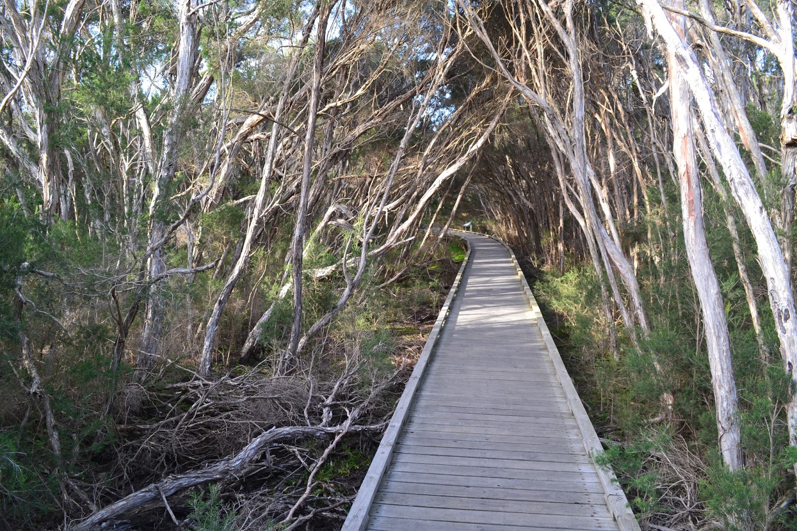
Parking at the catchily named Balcombe Estuary Recreation Reserve I shouldered my pack and headed up the estuary toward the Briars. The walk up Balcombe Estuary is mainly along an extensive board walk and while the Paper Bark and Tea Tree salt marshes were pretty dry today the boardwalk section still makes for great walking. With the blue sky and a late afternoon sun I found myself stopping frequently to try and capture the essence of the place. The boardwalks passes numerous lookouts over looking the still, dark water of the estuary, some of the locals making use of the estuary access to fish for bream. 
Balcombe Estuary, Mount Martha.
There are long sections of boardwalk on this stroll.
Lots of opportunities to gaze out over the still water of the estuary as well.

Eventually the estuary becomes Balcombe Creek and the track crosses to the north side for a few hundred metres before once again crossing back to the south and walking some more boardwalks. Crossing under the busy Nepean Highway the track enters the Briars Park, today though I wasn't going all the way to the historical homestead, instead after a bit more duck boarding I crossed over Balcombe Creek for the last time and started up Harrap Creek Trail. I'd noticed this trail last time we walked down here and was interested to see where I would end up. 
I got a beautiful Autumn afternoon for this walk.
There may not be any track notes but you want get lost on this stroll.
Balcombe Creek above the estuary.

Harrap Creek Trail headed in a general northerly direction along, yeah you guessed it, Harrap Creek. The track was another well formed easy path, initially passing through a section of native bush which was looking good in the late afternoon sun.  After crossing the suburban Craigie Road I was suddenly walking through well manicured parklands on concrete paths. Now this isn't my favourite type of walking and I'm not going to embellish it by telling you how much I enjoyed it, but at least the section up to Bentons Road was more or less in a native bush corridor. Once I met up with Bentons Road I headed west into the setting sun towards the bay, the best I can say about my couple of kilometres along Bentons Road was that at least I had a footpath to walk on, the easy walking allowing me to watch the people rushing past in their cars on their way home from from their working week, everybody seemed to be in a hurry to get to wherever they were off to.


Harrap Creek Trail.
The first section of Harrap Creek Trail passes through lots of native bush.
Before passing through more manicured parkland.
Bentons Road was a little uninspiring.
Reaching the bay near a beer barn from my youth, the Dava Hotel, I turned south and headed back along the coast towards Mount Martha. This was another section of the walk that I hadn't walked before and it was really good walking. The track passes through extensive coastal scrub and keeps quite close to the cliff tops, and with the sun now slowly sinking into Port Phillip Bay the light was suddenly pretty good to take photos. There are numerous lookouts along here with views down towards Mount Martha and Arthurs Seat in one direction and Snapper Point with the high rises of the Melbourne CBD in the other direction. When the boat sheds started to come into view below me I dropped down to beach level and meandered my way along the soft sand, the numerous colourful boat sheds adding to the scene.
The final coastal section made for good walking.
The sun was getting low now.

I was starting to get a little tired by this stage of the day, I'd been on the go since 6am that morning and had so far managed to fit in 6hrs of work, a thirty kilometre mountain bike ride and now a ten plus kilometre walk. So with the soft sand sapping the last of my remaining energy I was happy to see the Mount Martha Yacht Club which signalled that I was getting very close to the end of the walk. Leaving the beach I climbed up to the Esplanade and crossed the mouth of the estuary on the road bridge, using the bridge to support the camera I got a couple of long exposure shots in the now very murky light before walking the last few metres back to the ute. It was with some relief that I slipped off my boots and settled into the comfortable seat for the short drive home.
Snapper Point.
The late afternoon light on the coastal cliffs near Mount Martha.

The Dirt.
I walked 11.2 kilometres on this adventure and climbed 75 metres on this easy walk. I've deliberately been a little more descriptive of this walk as there are no published notes for the route, your best bet for navigation on this walk is probably the relevant page in the Melways. It's a walk of four parts really, the board walk through the salt marshes beside Balcombe Estuary being the best bit in my opinion. The section up Harrop Creek was OK as well, the road bash along Bentons Road was pretty ordinary though. The final section back to Mount Martha along the coastline is very good, so the walk finishes off on a high. Finally I've written up a walk from the Briars to Mount Martha back when I first start the blog here's the link to that post if your interested. 

There are plenty of boat sheds along the beach section.
My last shot of Balcombe Estuary.

Saturday, April 16, 2016

Arrowtown, Chinese Settlement Walk, New Zealand - December 2014

While I was resting in Queenstown for a couple of days last year, whilst waiting for Sam to arrive, I reluctantly tore myself away from the coffee shops for an afternoon and headed out to Arrowtown to check it out. Arrowtown is an old mining village just over 20 kilometres from Queenstown, the small village has a population of around 2400 people and next to quaint in the dictionary there is  a picture of Arrowtown. Arrowtown sprung up in the 1860's when gold was found in the Arrow River, luckily a lot of old historical buildings have survived the years and have been tastefully restored. 
The Chinese Settlement Walk.
Parking down near the park at the north side of town I firstly wandered over to the historic Chinese Settlement Walk. Arrowtown had a lot of Chinese prospectors back in the day, and like in Australia their treatment in New Zealand was sometimes very bad, the Chinese miners weren't even allowed their own claims and were left to rework old claims a lot of the time. The old settlement at Arrowtown is a good example of how the Chinese lived and worked in ye olde days. 
The old miners huts looked like they'd be good for hobbits.
Following the Swamp Gully Track along the banks of Bush Creek I passed numerous restored old mining shacks, some cut into the sides of the mountain. One of the interesting things about these old building is how low the roof and door height is, some of the doors were only chest height on me, those Chinese blokes must have been pretty short. Now while they may have been short at the same time they must have been tough, as it would have been a hard, cold and wet place to work and live. After less than half a kilometre (hey I didn't say that this was a long walk!) I picked up a track that linked up to Manse Road.


Once out of the gully I followed the quiet Manse Road for a few hundred metre away from town, there are some nice galleries out here and from the look of it today it seems that they are far enough from the centre of town that most of the day trippers don't get out here as I was the only person checking the works out. After checking out a couple of the private galleries I wandered back towards town along the quiet road climbing up to the old cemetery on the way to check out the well loved headstones and graves. These old cemeteries are great places to stop for awhile and take everything in, with a little imagination and with the information on the headstones its easy to imagine a little of what life was like out here a century or two ago.
There are a couple of private art galleries out of town a bit on Manse Road, this one featured a nice garden as well.
Arrowtown Cemetery.

Climbing above the cemetery I visited the small war memorial overlooking the main part of town, its old guns standing like sentinels over the town. My thoughts now turned to coffee, it had been at least two hours since my last caffeine hit so I was obviously doing it hard. Making my way down to the main street in Arrowtown, Buckingham Street I crossed over another little trail, the Te Araroa Trail, now that's a little stroll that'll will have to wait until I retire I reckon, but gee it looks good. The main street was a hive of activity this afternoon and after grabbing a coffee I wandered around for an hour or so checking out the galleries and shops, if history or shopping was your thing you could easily spend a day exploring Arrowtown and still be left with something to see I think. Today however I was running out of time, so with a little reluctance I jumped back in the car and headed back to Queenstown, I'll definitely be back in Arrowtown again one day to spend some more time checking it out, next time hopefully with Sam.
One of the old guns that stand like sentinels over looking down town Arrowtown.
Another one for my bucket list.
Arrowtown is impossibly quaint.
The Dirt.
I didn't really use any notes on this walk, the Chinese Settlement Walk has a paragraph in Excellent Short Walks In The South Island by Peter Janssen and the DOC brochure Wakatipu Walks also has a very short description in it. All you really need to do here is to head to the visitor information centre and grab a tourist map of Arrowtown and then explore where ever takes your interest, you're not going to get lost in Arrowtown.

The main street is home to some great shops, galleries and cafes, I'll have to come back one day with Sam.


Monday, April 11, 2016

Lysterfield Lake - April 2016

Since my trip up to Mount Bogong a couple of weeks ago I haven't actually got off the couch and done a walk, I've thought about it, but when the time came to head out of the house it would all get to hard, apathy would set in and I'd go nowhere. So this weekend I was keen to get out and do a walk. After considering all the hardcore walks I settled on something a little easier, Lysterfield Lake, yep a 6 kilometre amble in the suburbs of South East Melbourne, maybe apathy hadn't quite finished with me yet! Lysterfield Lake use to supply the Mornington Peninsula with water up until Cardinia Reservoir came online in 1975, since then its been used for recreation and conservation as well as being one of Melbourne's premier mountain biking destinations, infact the Melbourne Commonwealth Games mountain bike course was at Lysterfield Lake, but as I still haven't worked out how to do a good cycling post I decided to leave the bike at home and do a walk instead.
Spotted Gums are the tree of choice today.
So after our normal leisurely Sunday brekky down in Mornington I dropped Sam off at home at headed out to Lysterfield. The park is an extremely popular spot for a picnickers and there were plenty of families out this afternoon enjoying the warm afternoon, leaving the ute I wandered down towards the lakeshore past the picnickers with their sizzling bbq's, briefly considering whether they'd notice if I joined their picnic. Passing above the sandy swimming spot I headed for the dam wall, crossing over to the western side of the lake.
Lysterfield Lake below the picnic area.
The western side of the lake has a lot of Spotted Gum plantations, the uniform rows of trees standing out. I stayed below the plantation though and headed along the wide Casuarina Trail and then the less well defined Acacia Trail close to the lake shore. Acacia Trail was the pick of the trails on this walk as it passed through a conservation area full of native flora and fauna and the path was more like your typical bushwalking pad, the pad twisting and turning and generally seeming to take the most convoluted route to its destination. Halfway along Acacia Trail I broke out into an open grassy area that looks like its grazed by the local roos, the open area was home to around half a dozen humpies  in various states of repair, what's the go with humpies now days? It seems to be every second walk I do around Melbourne now days I come across a humpy, they certainly haven't been here since our indigenous people lived here, are they being built as a reminder of our indigenous heritage, by kids, by local indigenous people? 
The western and northern shoreline is a little more natural.
Uniform rows of Spotted Gums, if you look close you may see a mountain biker weaving through the trees on Tramline Track.
I'm not sure what the go is with all the humpies that seem to be springing up around the place.
Acacia Track.
After around 1 kilometre Acacia Trail re joins Casuarina Trail and I strolled up the wide gravel track through fairly open forest to the northern end of the lake, the walk then follows Short Cut Track for a short distance crossing over the lake inlet on the way, the creek feeding the lake being bone dry at this time of the year. Turning south onto Lake Track I started back towards the ute, the sun now making the odd appearance through the cloud. While this is a lakeside ramble you don't actually get a lot of water views on this walk so I was keeping an eye out for an unmarked track on my right that would lead me through the scrub to small jetty. Eventually I found a likely looking pad and headed bush, sure enough after 50 metres I got to the small jetty that led me out onto the water at the north end of the lake. Lysterfield Lake is a little more natural at its northern end, the banks lined with reeds and Tea Tree growing down too the water line, if I could have been bothered swapping lenses on my camera I could also show you a few of the water birds that make this end of the lake home, yeah I coulda.
Even on a suburban stroll I've managed to draw blood!
A lot of the immediate area around the lake is fenced off for conservation.
This is the un-marked pad that your looking for if you want to visit the small jetty at the northern end of the lake.
Looking down Lysterfield Lake towards the dam wall.
Leaving the hidden jetty I was on the homeward stretch now, first up I continued along the wide gravel Lake Track for awhile before turning onto a walking track through a conservation area. This last section through the conservation area was again nice walking, I think it would be even better in winter as the track crossed some reasonable length sections of duck boards. At the end of our long dry summer the wet areas were bone dry but with a bit of rain it would be very nice walking through the Tea Tree and Paper Barks with a bit of water on the ground. All good things come to an end though and after leaving the conservation area I was back in the extensive car parks that service the lakeside picnic areas and soon back at the ute. Taking off my boots I listened to some excited mountain bikers talking about their day, I couldn't help but to smile to myself and think how lucky we are to have such great facilities and live in such a great country.
Back on Lake Track and heading for the ute.
It was a little dry on this visit.
The walk finished off with a nice section across some duck boards in a conservation area.
The Dirt.
I walked 6.8 kilometres and climbed 82 metres on this very easy stroll. The walk would be suitable for strollers or wheelchairs if you stayed on Casuarina Trail and didn't take the Acacia Tail. I used the notes out of the Woodslane book Melbourne's Best Bush, Bay & City Walks by Julie Monday. Parks Vic have a lot of good free information online and with the variety of options on offer in the park its worth getting online to check it all out.
 The car parks in view and the walks rapidly coming to an end.
Now this has got absolutely nothing to do with Lysterfield Lake. This photo was taken over my back fence and I'm putting it on here to see if anyone can tell me what the reflections in the cloud are, now I'd like to think its the sun reflecting off Inca cities in the sky, but I actually think that seeing we live to the south east of the Melbourne CBD its the shadows cast by the buildings in the city.....but then again.

Pelion Hut to Mt Ossa return, Overland Track - April 2010

Mt Oakleigh from the Pelion Hut heli pad. I think the mountain just visible in the mist in the distance is Cradle Mountain... ... the flat t...