In late November 2006 my mate Dave and I decided to head up to New South Wales for a weeks walking holiday, one of the places we walked was in the Bungonia State Recreation Area. Apart from the catchy name the park is famous for the fairly impressive Bungonia Gorge as well as the mighty Shoalhaven River which flows through it. On our walk we planned to visit both these features and also spend a night camped on the banks of the Shoalhaven, before climbing back up to the troopie.
 |
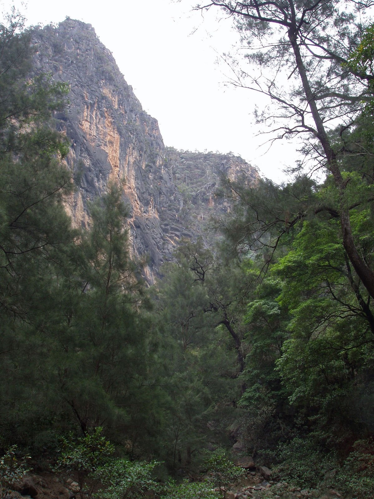
The huge cleft of Bungonia Gorge from Red Track.
 |
| There are plenty of grass trees in the dry forest above the gorges. |
|
Day 1 Shoalhaven River / Bungonia Creek Bush Camp 14 kilometres
We left the troopie on a grey humid day, with virtually no climbing on the cards for today we weren't to worried about the heat though. Of more concerning to us was to time our walk along Bungonia Creek to avoid the blasting in the quarry above us, as rocks were known to shower down into the creek, the park's people close the track when blasting is due to occur. First up today though we had to descend into Bungonia Creek and that involved a very steep and slippery descent down the imaginatively named Red Track.
 |
Heading up Bungonia Creek towards the gorge.
 |
| Scrambling through the labyrinth of boulders on Bungonia Creek. |
|
With some relief we finally reached the banks of Bungonia Creek, stashing our packs we headed off on a side trip up to check out the stunning Bungonia Gorge. On paper this looked like a fairly straight forward walk upstream, however the bed of Bungonia Creek back towards the gorge consisted of a jumble of house sized boulders that had to be climbed over, under or around, making for slow going. The boulders eventually thinned out a little and got a little smaller and we entered the gorge, with the walls of the gorge towering over 100 metres above us we took in this stunning place, we felt like we could almost touch both sides of the gorge with our arms outstretched. Apart from being caught in the gorge in a flood you also have to be careful down here in strong wind, with the shear walls towering over 100 metres directly above your head its not unknown for debris to rain down on unsuspecting walkers in the gorge below.
 |
Easy walking through a forest of casuarina saplings.
 |
Bungonia Gorge, the grey skies and crap photos aren't doing any favours to the scenery on this post.
 |
| Heading back down through our boulders. |
|
|
We didn't have to worry about wind though today but rain on the other hand appeared a real possibility. After retracing our route through the labyrinth of boulders we grabbed our packs and set off down Bungonia Creek towards the Shoalhaven. The first obstacle was to get through the blast zone, the next obstacle was to walk past the beautiful emerald green swimming holes in Bungonia Creek. Reaching the junction of Bungonia Creek and the Shoalhaven River we set up our tents on a small riverside beach, the next objective for the day was a quick swim to wash off the accumulated sweat and grime. After our quick swim we set off to explore the Shoalhaven up towards Louise Reach, the weather had deteriated by now and we walked in constant light rain in our wet weather gear, Dave's poncho was perfect for the warm rain, my gortex jacket not so perfect. The banks of the river provided easy walking though and we made our way along through groves of casuarinas. Reaching Barbers Creek we refilled our water bottles and turned around and headed for camp for an early night in the tent caching up on some reading.
Day 2 David Reid Car Park 8 kilometres 22 kilometres total.
We woke to another warm and humid day although at least the rain had stopped for the time being. Packing up camp we started up White Track on what was a fairly tough climb, the initial section after leaving the river in particular was a steep and slippery affair. Stopping frequently and sweating profusely we slowly made our way towards our high point at Mt Ayre. Some compensation for the effort and discomfort were the views though, as we climbed higher the views up and down the steep sided valley that the Shoalhaven River flows through became more impressive, I'd love to do this on a nice blue sky type of day...one day.
 |
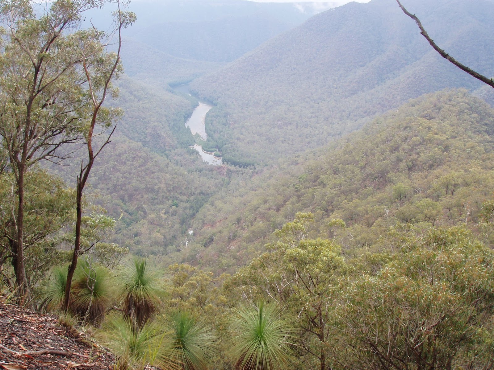
The view back towards Bungonia Gorge on the climb up White Track.
 |
You can just make out the river through the trees.
 |
| The Shoalhaven River. |
|
|
Reaching Mt Ayre we then followed the undulating track back towards the car park. The forest up here away from the creeks consisted mainly of dry eucalyptus with the occasional grass tree. Less than three hours after leaving our camp on the river we arrived back at the troopie, smelly and sweaty but happy with our Shoalhaven adventure.
 |
The steep climb up White Track.
 |
| Almost there Dave. |
|
The Dirt.
I can't remember who's notes we used on this walk, I think they may have been from one of Tyrone Thomas's Bushwalking in New South Wales books (maybe?). This walk is only short but its rough in a few places, the climb out is also a bit of a ball breaker, so I suppose I'd rate it as a medium walk. Unfortunately the weather didn't really cooperate our trip but if the sun was out and the weather was warm this would be a sensational trip if you like to combine swimming with your walking, as I do.
 |
| The Shoalhaven from near Mt Ayre. |


No comments:
Post a Comment