Our second day on our Wilsons Promontory walk started off a little overcast and humid, while we ate our breakfast and packed up camp at Roaring Meg I half expected that the storm clouds might roll in at any minute. Luckily for James and I though, the over head conditions just stayed dull and grey, well lucky in that we weren’t walking in rain but unlucky in that our photos suffered a bit with the washed out sky. We were on the go fairly early today as we had another fairly long day in front of us, filling our water bottles out of Roaring Meg Creek we set off for the lighthouse just after 8am.
 |
| Filling up the water bottles at Roaring Meg Creek on what was a fairly early start for me. |
Leaving Roaring Meg the track toblerones a bit as it climbs and then descends in and out of consecutive valleys, so by the time we broke back out onto the Lighthouse Track for a short stretch we were well and truly warmed up again. With my shirt already moulded to my back with sweat, I could only ruefully smile to myself and think that I really should be sitting in a café somewhere reading the weekend papers and drinking coffee instead of trudging up and down hills with 20 kg strapped to my back. After a very short stretch along the Lighthouse Track Fire Track we turned off onto the walking track and started the fairly long descent down to the lighthouse, this is a really nice section of track if you’re heading down, coming back up is not a lot of fun though. It wasn’t long before we started to get our first glimpses of the lighthouse through the trees, standing proudly on its rocky promontory, always a sight that gives me a bit of an energy boost.
 |
Starting the descent down to the lighthouse.
 |
| Our first glimpse of the lighthouse, conditions were a bit overcast this morning. |
|
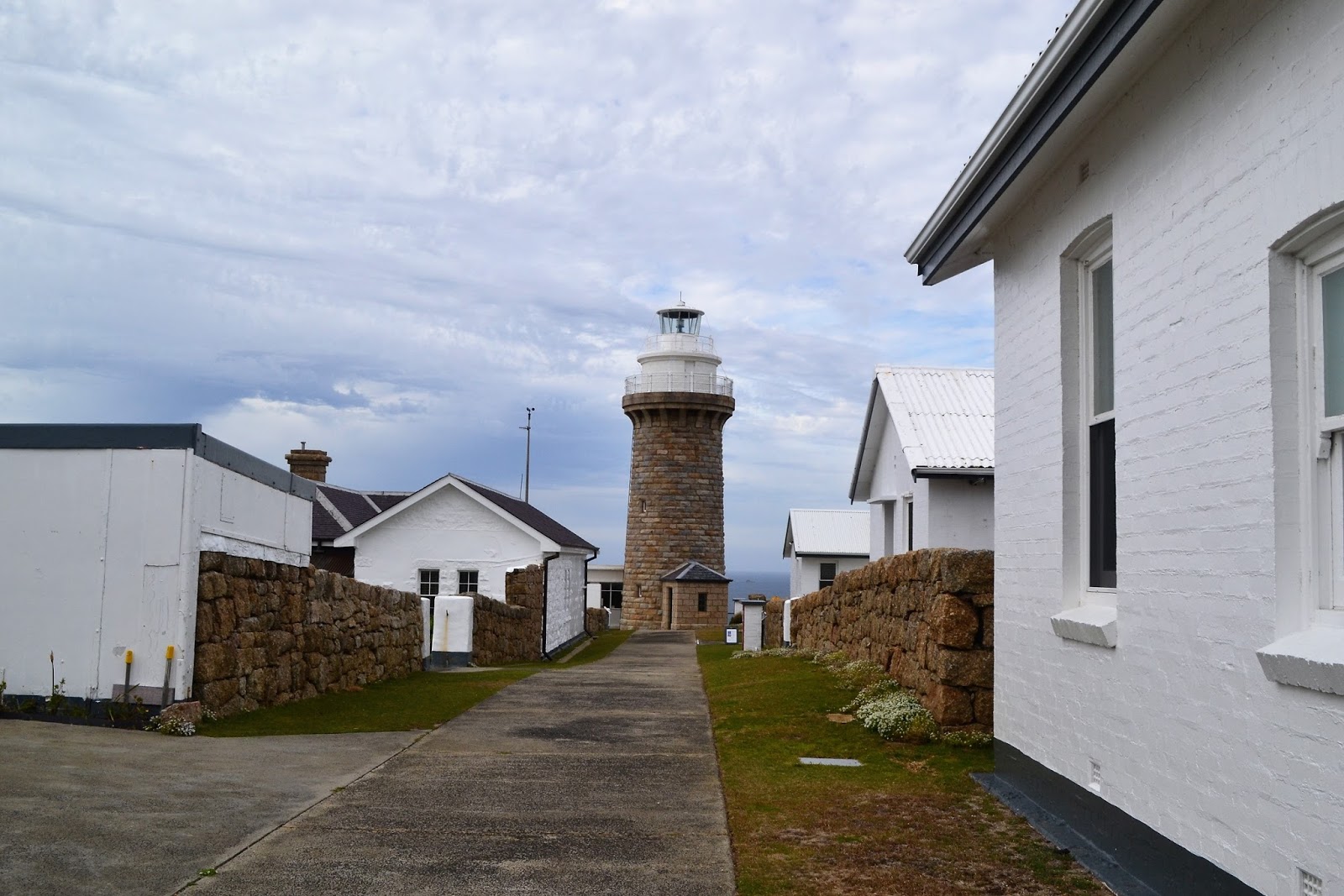
After checking out a new lookout that wasn’t there last time I was down here, we continued our walk down towards the lighthouse. Meeting up with the lighthouse access track we left our packs beside the huge boulder that marks the track junction and meandered down across the isthmus that connects the rocky promontory on which the lighthouse sits to the mainland. Now for anyone who has ever been here before they’ll inevitably remember the concrete path up to lighthouse, it’s a steep heart breaking climb and today was no different, even though I knew what was coming. After a final steep climb we arrived at the seemingly deserted lighthouse, I’ve stayed here numerous times over the years but this was James’ first visit so he was keen to wander around checking out all the information boards and the small museum, not to mention the stunning views.
 |
| The Wilson Promontory Lighthouse. |
 |
The trudge up the concrete track to the lighthouse passes right beside these huge wind scoured boulders, not a bad excuse for a stop really.
 |
 |
One of the accommodation cottages at the lighthouse, there are worse places to spend the night!
 |
| There is a lot of history both in the museum and scattered around the lighthouse precinct. |
|
|
|
Leaving the lighthouse we retraced our steps back up to our packs stashed at the huge boulder I’d mentioned earlier, it was here that a near disaster visited James. He’d left his pack beside the rock with the zips facing out from the rock and the local currawongs had paid a visit in our absence, they had managed to open the zips on the top and back of his pack and have a bit of a snack on James’ food supplies, in the process spreading the contents all over the ground. So here’s a Feral hint, when leaving your pack for any length of time on the Southern Circuit make sure that the local currawongs can’t access your zips otherwise you risk getting ransacked. Luckily for James they didn’t get too much, making more of a mess than anything. Shouldering our packs again we set off towards our next beach at Waterloo Bay, before getting to the blinding white sand of Waterloo Bay though we had to do a bit of climbing along the Boulder Range.
 |
| James' pack after the currawongs had picked out all the good stuff! |
The track around to Waterloo Bay initially sidles in and out of a few gullies before, after crossing one last creek (probably the most reliable between Roaring Meg and Waterloo Bay) the track suddenly turns and starts to climb up a spur. The climbing is never overly steep but its pretty relentless, the variations in eco systems as we climbed helping to take my mind off the slog. Nearing the highest point we started to get a few views from the huge granite boulders littering the Boulder Range, initially the views were back down towards the now somewhat distant lighthouse, but a little further on we got out first look down to the white sand of Waterloo Bay. What goes up has to come down and like the climb, the descent is a long one, the track builders put a lot of effort in along here with a fair bit of dry stone paving and steps helping to ease our passage.
 |
The track around to Waterloo Bay starts fairly easily.....
 |
....before starting to climb up this spur.
 |
The lighthouse looks a little further away now.
 |
Cape Wellington
 |
Waterloo Bay and Little Waterloo Bay.
 |
| The track down off the Boulder Range a long descent, but fairly easy. |
|
|
|
|
|
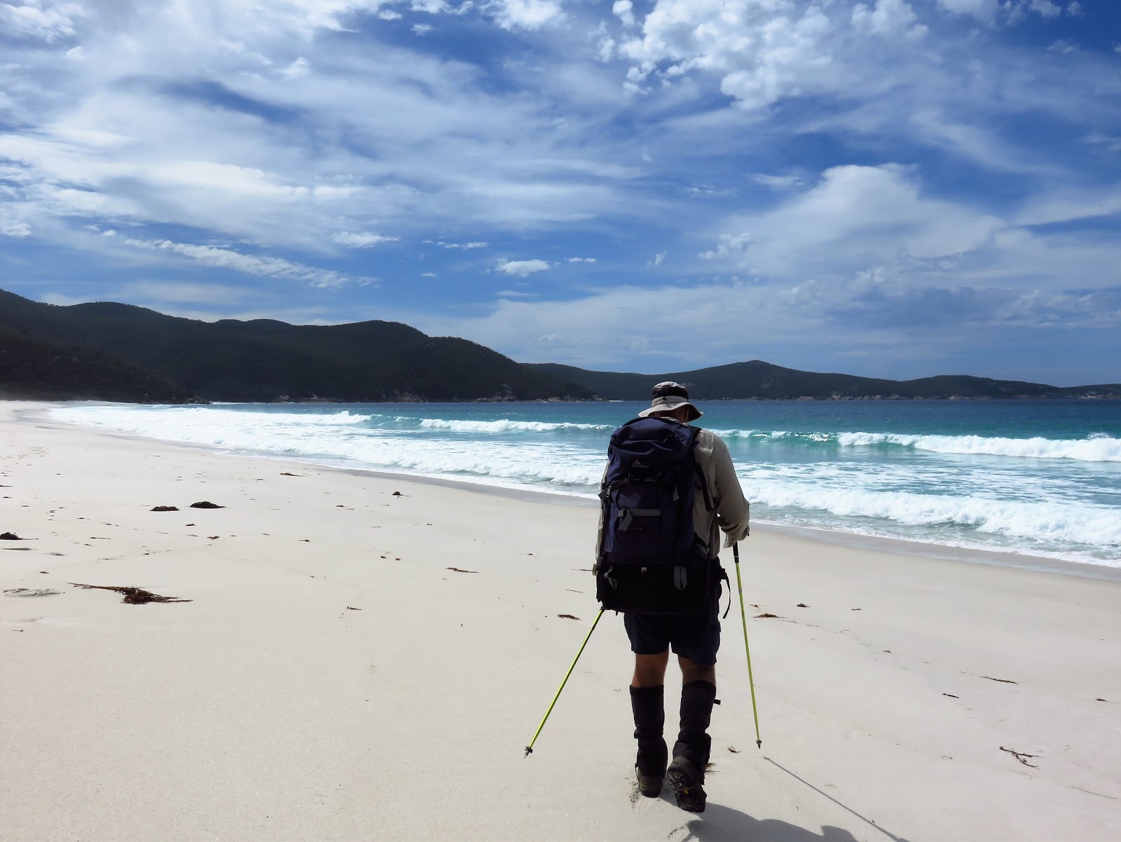
So far on our stroll since leaving Norman Bay we had really only seen a hand full of other people, but dropping onto the soft sand of Waterloo Bay signalled the point that we would meet up with the more popular shorter circuit and from now on we would never be short of company for long. Waterloo Bay is one of the prettiest beaches down at the prom but it’s a bit soft for enjoyable walking I reckon, still with no other option available to us we ploughed our way up the soft beach. Slowly but surely the orange lichen stained rocks that mark the headland between Waterloo and Little Waterloo Bay drew closer. Crossing the tannin stained water of Freshwater Creek we climbed up onto the small headland and walked a roughish section of the track, made less painful by the numerous ocean views, over to the Little Waterloo Bay Camp for a late lunch.
 |
| Trudging along the soft sand on Waterloo Bay. |
 |
Waterloo Bay
 |
 |
Freshwater Creek
 |
| The track between Waterloo Bay and Little Waterloo Bay is a little rough but the views more than compensate. |
|
|
|
The camping area at Little Waterloo Bay was already filling up with punters even at this early hour which made my wonder what Refuge Cove would look like when we got there in a few hours. The cloud that had accompanied us for most of the morning had now largely burn’t off and the heat was starting to take a bit of a toll on our energy levels, so the steep climb out of Little Waterloo Bay wasn’t really appreciated that much. Stopping at a lookout on a large sloping granite boulder I explained to James that it was tradition to stop and take in the view from here, although I think the tradition has as much to do with getting my breath back as it does the view! Leaving the rock lookout the track slowly descends to the next beautiful beach, this time North Waterloo bay where we beach combed our way along to the first rocky outcrop which marked the spot of the beginning of our last solid climb for the day.
 |
Little Waterloo Bay
 |
The traditional place to stop, looking back towards Waterloo and Little Waterloo Bay.
 |
North Waterloo Bay
 |
James staggering beach combing his way along North Waterloo Bay. |
|
|
|
With the turquoise water of North Waterloo Bay receding through the trees we slowly gained height as we trudged up towards Kersop Peak. The old track up here use to be a steep eroded bitch but this new one makes the climb very easy (by the way, the new track has probably been here for 15 years now!), with the track starting to pass through a section of granite boulders I knew that we were getting close to the turnoff to Kersop Peak. Sure enough our side track soon materialised out of the scrub and after grabbing a bite to eat and some water, oh yeah and making sure that the currawongs couldn’t raid our packs we set off up the side track to the top of the peak. Kersop Peak marks the last time on the walk that we would be able to see the lighthouse, the flattish rock at the top also marks a good spot to lay down and recover for awhile, well at least it did for us.
 |
The start of our climb up to Kersop Peak.
 |
 |
Hey, hey, we've made it up to Kersop Peak, the weather is looking a little dubious though. This was our last look at the lighthouse.
 |
| I think it's tradition to lay on this rock when you climb Kersop Peak. James is looking a bit shattered! |
|
|
|
It looked like the weather was turning again, it was still pretty warm but dark clouds were now starting to roll in over the hills so it wasn’t much of a decision to start making our way down to Refuge Cove. Where as up until now most of the views had been to the south from here on we started to get views to the north initially of North Refuge. The track down to Refuge Cove from Kersop Peak is a pretty good one and it wasn’t long before we emerged from the scrub onto a long rock slab to see the boats anchored in Refuge Cove bobbing in the gentle waves below us, a couple of minutes later we were a camp. After filling up our water bottles we found ourselves a couple of nice spots to pitch our tents and settled in for the night, with almost ten hours walking today it was nice to pull the boots off and chill out for awhile while we ate our freeze dried dinners.
 |
Dropping down to Refuge Cove we had one last view south, this is North Waterloo Bay - we had climbed Kersop Peak from the rocks in the middle of the beach.
 |
Refuge Cove
 |
| Refuge Cove Camp. |
|
|
The Dirt.
We walked 25.1 kilometres and climbed 1155 metres on this hard days walking. Unlike the first day the majority of todays walking is on walking tracks or beaches which makes it more enjoyable in my eyes. I’ve never walked from Roaring Meg to Refuge Cove in a day before, every time that I’ve done this circuit before I’ve stayed at the lighthouse which knocks around five or six kilometres of the stroll and makes the distance a little more manageable. There was a fair bit of climbing involved today but the good news is that the tracks are very well engineered and the climbing never really gets too steep, its just a matter of putting your head down and chugging along.
Relevant Posts.
 |
| James chilling out in the creek, it might of been overcasts but it was still pretty warm. |
 |
| Mmmmm......freeze dried, I'm not sure why James is smiling really? |
 |
| Totally Feral.....socks and thongs...yeah it's a good look! |


No comments:
Post a Comment