 |
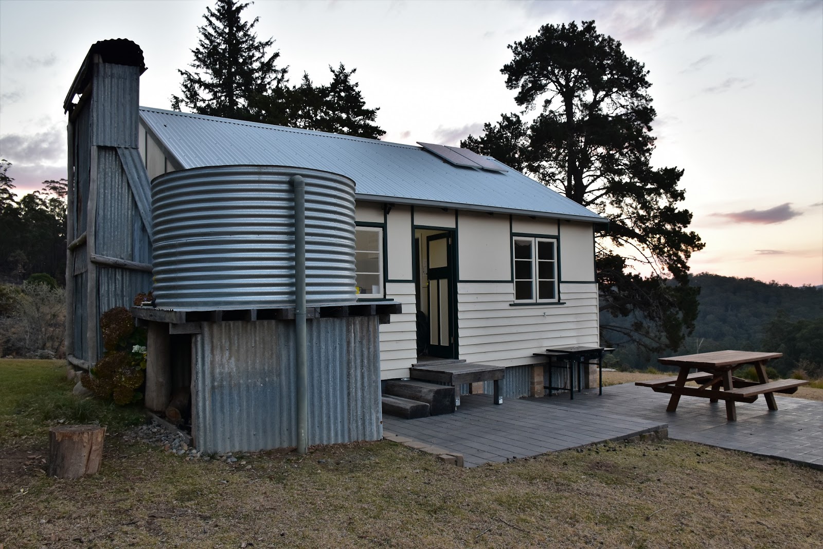
| The Green Gully Walk starts with a night at the very nice Cedar Creek Hut. I'm assuming the NSW Parks people made this a 5 night/4 day walk due to the distance most people have to travel to get to the start/finish point - it's a good two hours from Walcha, which itself is generally a fair drive for most people. |
I’ve been planning this trip up to walk the Green Gully Track for 6 months or so. A winter walk in the New England region of New South Wales always had it’s potential issues, but it turned out it wasn’t the weather that threw a bit of a spanner in the works of this walk. I’d been planning on doing this walk with a blogging friend of mine but a last minute injury prevented prevented her from coming with me. Now I faced a bit of a dilemma, with the money paid and huts booked, not to mention my annual leave approved, I wasn’t overly keen to miss out. Having walked a lot harder tracks than this one on my own I decided that doing it solo was the go, my biggest worry was that I might go a little stir crazy sitting around the old huts at the end of each day….time will tell I suppose.
 |
| The Central Western Plains of New South Wales are in the middle of a pretty severe drought at the moment - just don't mention climate change to the cow cockies! |
 |
| Sunset from Cedar Creek Hut, it was certainly better than the typical Melbourne mid winters sunset that I'm normally looking at. |
After a long road trip up from Melbourne that was punctuated by a climb up The Rock and a few hours sleep up near Coonabarabran, I arrived in a cloud of dust at a very dry looking Oxley Wild Rivers National Park. New South Wales is currently in the midst of a very serious drought and since leaving Coonabarabran that morning I’d been passing through country that sometimes seemed like a dust bowl. Arriving at Cedar Creek Hut the desolate scene wasn’t helped by a recent prescribed burn that had been carried out in the area, the area surrounding the hut being a patchwork of burnt and unburnt areas. Apart from the obvious visual scars in the surrounding area, Cedar Creek Hut provided for a very comfortable night, certainly a lot more comfortable than it was sleeping in the ute last night. After getting the fire going and having a hot shower I settled in for a relaxing night as I pottered around sorting out my gear for tomorrow’s walk.
 |
I had a pretty comfortable night at Cedar Creek Hut.
 |
| Hey, hey, I even had a real bed (BYO doona by the way!). |
|
I slept very well on my night Cedar Creek Hut, the local wildlife scurrying around the hut only disturbing my once or twice. Prying open my sleep encrusted eyes this morning I was happy to see that the day looked pretty good, although heading outside for a stretch I could see that I’d obviously slept through a bit of rain last night as there were a few puddles of water around. On the literature that the NSW Parks people supply for this walk they mention that is important to hit the track early to make sure that you arrive at the next hut before dark, so after breakfast I moved the ute over to the nearby Cedar Creek Lodge (the finishing point of the stroll) and set off at the crack of….9am, yeah that’s early somewhere in the world I suppose.
 |
There is a lot of wildlife around, and in some cases in the huts.
|
On paper today looked a little uninspiring with the whole days route following closed 4wd tracks and while I’m not going to wax lyrical about how great it all was, I will say that it was a lot better than I’d feared. Crossing a open grassy area that resembles a paddock I was escorted to the tree line by mobs of Kangaroos who were all our enjoying the morning sun, the roos certainly weren’t skittish as they held their ground until I was very close to them. I was following Kunderang Trail today and once I’d climbed into the trees it wasn’t long before Kunderang Trail started a fairly long ridge walk. Initially the ridge top was pretty broad but as I shuffled my way north towards a spot on my map imaginatively called Kunderang Brook View, the ridge got fairly acute and the views improved immensely.
 |
I was on my way at a reasonable hour.
 |
I left the ute parked near Cedar Creek Lodge, Cedar Creek Hut is a couple of hundred metres away up the hill.
 |
There was no shortage of Kangaroos out enjoying the morning sun.
|
|
|
As you’ve probably guessed Kunderang Brook View (kinda makes you wonder why we couldn’t of named some of these spots in the language of the local indigenous Thunghutti people, although having said that maybe ‘Kunderang’ is an indigenous name?) gave me a very nice look down into the valley of Kunderang Brook. Apart from having Kunderang Brook running through it and the valley looking very pretty this morning with a blanket of fog, the other interesting thing about this valley is that the Bicentennial National Trail runs through it, the BCT is allegedly the longest way marked route in the world (I’m thinking that new trans Canada Trail might have it pegged though?). People have walked the BCT but horses are a more common method of transport, I’ve always though it might be an adventurous Mountain Bike trip too, if only I didn’t have to work:)
 |
After a few hundred metres Kunderang Trail climbs into the trees and stays there for the rest of the day.
 |
Kunderang Trail
 |
| Kunderang Trail follows a ridge crest for much of the day. |
|
|
It was good to drop my pack for awhile at the lookout. In theory with me not having a tent, sleeping mat and a cooker it should of meant that I had a lighter pack, in reality it just meant I threw in a few luxuries so in the end my pack was more or less at the weight it normally is when I’m camping, at least with most of the luxuries of the edible variety my pack should get pretty light by the end of the walk….well that’s the theory. The good news this morning was that my back was holding up surprisingly good, although my lingering man flu was still giving me a hard time! Shouldering my pack again I set off north along the ridge line on Kunderang Trail again, the sunshine lighting up the green grass and keeping my mojo up as I slogged over a series of short but relatively steep knolls.
 |
Kunderang Brook Lookout.
 |
 |
Kemps Pinnacle from Kunderang Brook Lookout.
 |
Kunderang Brook Lookout is a nice spot to kick back for awhile for a bit of a smoko.
 |
The land in the national park was actually looking in a lot better nick than I'd feared, considering that NSW is currently in the middle of a nasty drought.
|
|
|
|
|
Arriving at the turn off to Colwells Yards it was time for my first lunch, although before eating I decided to make the relatively short side trip down to check out the old stockyards. Green Gully Track largely utilises old stockman's huts and consequently there is a lot of the old pastural relics scattered around the bush, the farming history is a real feature of this walk. Colwells Yards are a lot more recent than a lot of the other relics scattered through the bush around here, they only date back to 1994 and were used as a holding yard for cattle before they were loaded onto trucks and transported out to the markets back in the day. The old yards now makes an evocative sight sitting silently in the bush, the old mans beard on the wooden fence rails moving in the breeze reminding me that the weather here isn’t always this benign.
 |
The fog has lifted from Kunderang Brook Valley.
 |
As well as the sign posting there are also quite a few information boards on the walk.
 |
The grassy track down to Colwells Yards gave my feet a bit of a break.
 |
Colwells Yards
 |
The old yards date back to 1994.
 |
| The weathered wood had its own beauty I think. |
|
|
|
|
|
After launch it was time to set off again on my Toblerone like walk along Kunderang Trail. The highlights started coming thick and fast now, first I passed the turnoff to Colwells Trail which would be my return route in a few days, then I passed the emergency meeting point and then Kunderang Trail started to climb and curve around to the west and then finally to the south, up to what would be my highest point of the day. It almost goes without saying that almost as soon as I reached the high point and dropped my pack for lunch number 2, the forecast rain arrived. With the rain starting to come down and a bit of thunder reverberating through the trees I didn’t linger up here this afternoon, scrambling around a bit I soon had my DSLR stashed in it’s dry bag, my jacket on and the pack cover in place, all was good in my Feral world again…if not a little damp.
 |
Back on Kunderang Trail.
 |
 |
| Trudging along this afternoon I decided it was time to drop the pack for awhile and have another break, while taking a piss in the middle of the track I looked up and noticed that I was on candid camera! They'd need a lens the size of the Hubble Telescope to site the Feral appendage though ;) There are a few wildlife cameras spread along the route. |
|
|
The good news was that I didn’t have long to go to reach my nights accommodation down at Birds Nest Hut, the bad news was that it was a pretty steep little descent which was now a little slippery in the rain. On reaching a gate and a junction on Kunderang Trail I took the side track which dropped even more steeply down to cross Brumby Creek, although the creek signalled the end of my descent as my nights accommodation was only around twenty metres away. Heading over to the hut I was quickly out of my wet gear, the novelty of a dry hut in the wet weather was something that I could get use too I think.
 |
I'm about to reach the days high point...and its about to start raining!
 |
With the rain coming down now I was pretty happy to see this sign.
 |
 |
| The last section dropping down to Birds Nest Hut is fairly steep. |
|
|
|
Birds Nest Hut is another old cattleman's hut and it made for a very comfortable spot to pass the rest of the afternoon and evening. After splitting some wood I soon had the fire cranked up as the rain came down on the tin roof, with my wet gear drying nicely I made myself a warm drink, grabbed my book and settled in front of the fire, life was indeed…good. The Huts of Green Gully sleep eight people with camp stretchers in some and bunks or single beds in others, I had been a little concerned that I may not be able to squeeze my ample frame comfortably onto a camp stretcher but there turned out to be no problem, the stretchers were around 2 metres long I’m guessing. Another good thing about the huts is that they came complete with comfy chairs, there would be no sitting on dodgy lumps of wood on this walk.
 |
Brumby Creek at Birds Nest Hut.
 |
Birds Nest Hut. I've got the fire going and my gears drying, this is the life!
 |
| Like all the other huts on this walk there is no shortage of wildlife around Birds Nest Hut. |
|
|
The Dirt.
According to my GPS I walked 20.3 kilometres and climbed around 715 metres on what I’d class as a medium grade days walking. Navigation wise everything today was pretty straightforward as I followed 4wd tracks for the whole day and they were all very well signposted. Once leaving Cedar Creek Hut this morning there was no water until I arrived at Birds Nest Hut, that wasn’t a real issue in the middle of winter but it’s something to consider in the warmer months. I used the topo map that the NSW Parks people give you when you book the walk, the map along with my GPS was all that I needed. Today looks pretty cruisey on paper, but the ridge walk is a real roller coaster with lots of reasonably short, but sharp climbs and descents so it’s a little harder than may be imagined.
Relevant Posts.
The Rock, The Rock Nature Reserve - Kengal Aboriginal Reserve, 2018.
The Grand High Tops, Warrrumbungle National Park, 1999.
 |
| Birds Nest Hut. |
 |
| The thing with this walk is you get sole use of the huts, so I was able to spread my gear around getting everything dry without worrying about any late walkers turning up. |


No comments:
Post a Comment