Before I start waffling on today I need to thank both Neil and Rodney for getting in contact with me regarding fixing up my errant maps. Their advice is much appreciated and now I just have to put their great advice into practice….although I’m the kind of guy who is pretty happy when I turn my computer on and something appears on the screen, so it could take me awhile to put things into practise….but for anyone using my maps there is hope on the horizon! One other thing that I need to mention is that in the week and a bit since I did this walk there has been a bushfire near Werribee, I think it was a fair way from the park but this isn’t a place to be caught in a fire so maybe check out the Parks Vic ‘change of conditions’ before visiting, especially in summer and early autumn.
 |
| There has been a lot of rehabilitation work going on around Whyte Island. |
This walk was a cracker, although it’s not for everyone I don’t think. I’ve never featured Werribee Gorge in my blog before, a situation which needed to be rectified as it’s a magic spot that I’ve visited many times over the years (there’s that bloody sentence again!). The ‘go to’ walk over in the Werribee Gorge State Park has to be the main gorge loop, an 8 kilometre circuit that encompasses most of the parks well known highlights, however there is no shortage of stuff floating around the inter-web about that walk, so today I thought that I’d go a little Feral and improvise a bit when it came to the route.
 |
| I started my walk in the almost deserted Meikles Point Car Park. |
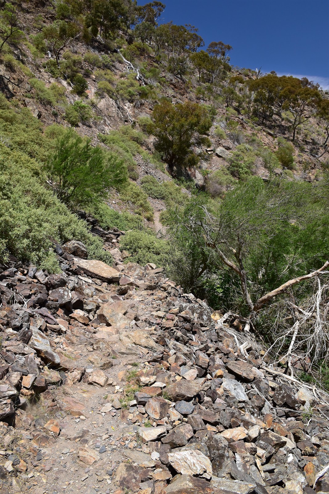
With the forecast for a low 30˚ day ahead I was on my way by around 9am this morning. A lot of people seem to park at one of the two car parks up near the entrance to the park, when I’m doing the gorge circuit in the anti clockwise direction I generally park down on the river at Meikles Point Picnic Area though. My cunning theory being that by starting my walk down here I get the climb over first and finish off with the beautiful gorge section last. After resetting the GPS I climbed up past the long drop and set off up the signposted Werribee Gorge Circuit. There was no real easing myself into this stroll though, the track climbing fairly solidly up a lightly wooded spur, although at least I had a few views opening up to the cleared land down towards Bacchus Marsh, which gave me enough of an excuse to stop a take a photo.
 |
There was no easing myself into the walk this morning, straight up I was into a climb.
 |
I did get a few views down toward Bacchus Marsh as I climbed.
 |
Heading across towards the Quarry Picnic Area.
|
|
|
After crossing the access road I passed through Quarry Picnic Area before climbing out of the old quarry and passing through the top car park. The walk actually leaves the state park for a few metres here as it heads up the sealed access road, crosses over a gully, before turning left and heading back into the park along the signposted gorge loop track. From here on things improved immeasurably as I now wouldn’t meet another road until I got back to the ute. After leaving the top car park the route climbs fairly solidly through an area that was a bit degraded but is now being revegetated, the new native vegetation is fenced off in spots to give it a fighting chance to establish itself before the marauding rabbits can get at it.
 |
Climbing up through the cliffs as I left Quarry Picnic Area.
 |
After passing through the top car park the walk actually follows the access road out of the park for a few metres.
 |
| There were a few fenced off plots of native trees next to the track as I started to climb again. |
|
|
Avoiding Centenary Track, which branches off to the right, I continued climbing the walking track around the top of a rocky spur. After passing Short Cut Walking Track on the left (you guessed it, a short cut back down to the start of the walk at Meikles Point Carpark) I arrived at the short side trip to check out my first lookout of the day. Eastern Lookout is only a couple of minutes walk from the main circuit walk but it’s definitely worth taking a couple of minutes to check it out. The view today was mostly over parched brown paddocks, over towards the B Doubles grinding their way up the Pentland Hills on the Western Highway. Looking slightly more to the north-west the scene was a bit more scenically pleasing as I was looking along the northern extremity of Werribee Gorge State Park up to the grassy, mesa like Whyte Island.
 |
Centenary Track heading off to the right is a fairly new track (at least in Feral years!), I was going left though.
 |
Climbing up towards the turn off for Eastern Lookout.
 |
It's a little hard to believe how close to Melbourne you are out here sometimes, the place feels very remote.
 |
| Looking towards the mesa like Whyte Island from Eastern Lookout. |
|
|
|
My walking track now meandered around the tops as I headed for what is arguably the best view point from which to appreciate the rugged Werribee Gorge. I don’t think this lookout has an official name so I’ll just call it the gorge lookout, you’ll know when you arrive though as the view off the sheer cliffs down to the Werribee River snaking it s way through the gorge, is very impressive. Across the gorge the rock buttresses near Falcons Lookout and Western Bluff towered ominously above the river, but with today already starting to get pretty warm it was the view down to the green water of Needles Beach that drew my eye, I already had it pencilled in for an afternoon dip later in the day.
 |
The Gorge Circuit meanders around a bit as it heads towards the Werribee Gorge Lookout.
 |
The You Yangs poking their heads out in the distance.
 |
Werribee Gorge
 |
| Needles Beach, I was planning on having a swim here later this afternoon. |
|
|
|
Leaving the gorge lookout it was only ten minutes or so before I arrived at Western Lookout. Not only did Western Lookout give me another good view down into the gorge but it also marked the spot where I’d start to improvise a little as far as the route went. After mentally noting my return route through a saddle on a very steep ridge on the other side of the river, I set off. Leaving the Werribee Gorge Circuit Walking Track I contoured my way north across some lightly vegetated, but pretty steep slopes. Dropping slightly I soon spied Centenary Track through the trees, the walking track dropping down a broad spur towards the river. Fifteen minutes or so after leaving the Werribee Gorge Circuit I was on Centenary Track and heading down to the river and all was easy again. Centenary Track is a relatively new walking track that allows easy access to a part of the park that use to be a bit harder to access, it also allows walkers to access one of my favourite swimming spots at Werribee Gorge, Junction Pool. I think the juries still out regarding the easier access to my remote swimming spot, but the walking track is handy for allowing quick access to Whyte Island.
 |
The view into the top section of the gorge from Western Lookout.
 |
The initial off track sidle was a little rough....
 |
....but things soon got a little easier.
 |
Once I emerged onto Centenary Track everything was good again.
 |
Dropping down Centenary Track towards Junction Pool. Whyte Island is looming large.
 |
Junction Pool
 |
| Junction Pool is another one of the great swimming holes that are scattered around Werribee Gorge State Park. |
|
|
|
|
|
|
Avoiding the watery temptations of Junction Pool, I crossed the almost dry Myrniong Creek and headed into the grandly titled W. James Whyte Island Reserve. The W James Whyte Island Reserve is some reclaimed farmland that Conservation Volunteers Australia are managing. The open grassy farmland now giving my a walk a completely different feel as I climbed fairly steeply up onto Whyte Island. Interestingly there is a plan to revegetate a corridor of native bush that will eventually link Lerderderg State Park, Werribee Gorge State Park and the Brisbane Ranges National Park and the W. James White Island Reserve is one part of that link. Climbing higher along an old 4wd track the volcanic geology of Whyte Island becomes visible in the sheer walls of some cuttings, not that I really needed much of an excuse to stop on what now a pretty warm day.
 |
Myrniong Creek was barely flowing.
 |
The walk along the side of Myrniong Creek was a little snaky today.
 |
Myrniong Creek has cut it's own nice little gorge.
 |
The climb up to the top of Whyte Island is solid enough but the track is pretty good.
 |
Walking up through the old farm land made for a bit of a change.
 |
Like I said, solid.
 |
| Whyte Island |
|
|
|
|
|
|
Like I mentioned earlier Whyte Island looks a bit like a Mesa, so once I reached the top the walking suddenly got very easy as I ambled my way around the flat topped hill. The volunteers have planted a lot of trees up here but it’s not hard to find a spot to check out the views through the trees. There is a signposted loop on top of Whyte Island and I wandered around it in an anti-clockwise direction today before eventually arriving at Island Lookout. Like most of the other lookouts Island Lookout gave me another view down over Werribee Gorge, more importantly though it gave me a look at the other side of the saddle that I’d have to cross over to get back onto the Werribee Gorge Circuit later on today, everything looking suspiciously flat and easy from up here I was thinking!
 |
This part of Victoria has a fairly recent volcanic history (relatively speaking).
 |
Looking over the valley of Myrniong Creek towards the distant Mt Blackwood from the top of Whyte Island.
 |
There has been a fair bit of revegetation action up on Whyte Island.
 |
Looking into Werribee Gorge from Island Lookout.
 |
| I was going to drop down this spur to meet the Werribee River on the sweeping bend. After reaching the river I was going to climb through the saddle above the river...it all looked pretty easy from up here. |
|
|
|
|
Leaving Island Lookout I backtracked a few metres to pick up an extremely steep grassy spur that dropped initially south-westerly before swinging around and heading south. This open tops of the spur being home to big mobs of Kangaroos that bounded away as I got closer. The Kangaroos were helpful though as I was able to follow their rough pads on the final steep and slightly scrubby drop down to the Werribee River. Once on the river flats I picked my way up-steam to a big looping bend in the river, arriving to find not only a good sized swimming hole but also a small sandy beach, always a bit of a bonus when I’m trying to ease my ageing, ample frame into the water with some kind of grace and dignity! Having made it this far into the day without having a dip I made up for it now, only leaving the refreshing waterhole to have a drink and a bite to eat for the next hour.
 |
There are big mobs of roos in this part of the park.
 |
I've never been into this part of Werribee Gorge before, but having been here now I'll definitely be coming back.
 |
On my next visit I think I'll try heading down the river into the gorge.
 |
The climb into my saddle looked a lot steeper from my waterhole.
 |
Lunch was a relaxing affair.
|
|
|
|
|
All good things come to an end, or so they say anyway, and I eventually figured that I’d better climb out head off again. Whilst I was drip drying on the rocks I sussed out the saddle that I’d have to cross over next, unsurprisingly it looked a lot steeper from down here. It was too steep and loose to just climb straight up so I decided to head left across the face to reach the base of a rock rib, from there I’d follow the base of the sloping rib up into the saddle. Thankfully after crossing the river and climbing a steep scree slope I reached the rocky rib to find it steep and loose, but a fairly reasonable climb. Fifteen minutes later I found myself standing in the saddle admiring the towering rocky buttresses on the ridge either side of me, ah yeah, there is hours of potential fun to be had out here! The really good news though was that my navigation was spot on as through the trees below me I could see the water in Blackwood Pool sparkling in the afternoon sun, and even more reassuring was that I could see the well defined Werribee Gorge Circuit descending steeply down the spur on the opposite side of the river from the Western Lookout.
 |
Time to start climbing again.
 |
I was sidling across below the saddle to pick up a rib of rock, which I then used to climb into the saddle.
 |
This is my best photographic effort at trying to illustrate how steep and loose the ground was.
 |
I'm about to pop over the saddle.
 |
| Looking down to Blackwood Pool (hidden in the trees) and the Werribee Gorge Walking Track, from my saddle. |
|
|
|
|
It was one thing to see the track though but another thing altogether to reach it. First up I had to find way down to Blackwood Pool from my saddle, once again the direct option wasn’t going to be on the cards if I wanted to get down in one piece. This time I slowly sidled my way east a bit onto a broad grassy spur which actually provided a fairy easy route down to the Werribee River. Reaching the river I headed back to Blackwood Pool and sussed out my next conundrum, I now had to get across the river and up onto the track, now that doesn’t sound to onerous but I’d been here before on another off piste ramble and I knew that it wasn’t a simple crossing. Pushing my way through the reeds and thistles I got to the downstream end of the substantial Blackwood Pool, further progress downstream on this bank was not going to happen due to an impenetrable wall of scratchy, stringy scrub. So now I was faced with a fairly deep wade, easing my way into the water off the rocks it was just a matter of carefully edging my way across towards the reeds on the other bank without going arse over in the water. It was only 4 or 5 metres but it’s a rough crossing and it’s also around waist deep so I needed to be careful, especially with my DSLR sitting in my pack. Reaching the opposite bank I picked my way easily through the reeds and then scrambled a few metres up another extremely steep climb, to re-join the Werribee Gorge Circuit a little way up the spur.
 |
Blackwood Pool is another great swimming spot, although the entry and exit is a little more problematic.
 |
Crossing the Werribee River at Blackwood Pool is a waist deep, boots on wade.
 |
Blackwood Pool
 |
| The exit looked a little nasty...it wasn't as bad as it looked though. |
|
|
|
Now I was once again back on the Werribee Gorge Circuit I wouldn’t have to worry about navigational issues for the rest of the walk, basically it was now just a matter of following the river downstream through the gorge. The Werribee Gorge Circuit is a really good walk (and judging on today’s informal Feral survey, very popular), and in my opinion the best bit of the circuit by far is the walk through the gorge. Since leaving the track earlier in the day over at Western Lookout I hadn’t bumped into another person, but now I was on the main circuit I was passing a steady steam of walkers out enjoying the warm weather.
 |
Now I was back on the main Werribee Gorge Walk there would be no more navigational conundrums.
 |
The gorge walk is surprisingly rough in spots.
 |
There are few spots where you need to scramble a bit.
 |
Werribee River
 |
Needles Beach.... time for another swim!
 |
| Yeah, just me and the Tiger Snake! He must of been just behind my right shoulder when I took this photo I'm thinking. |
|
|
|
|
|
Arriving at Needles Beach it was time to drop the pack again and go for another swim. Needles Beach was the swimming hole that I’d been looking down on from the gorge lookout many hours ago and I was a little surprised to arrive here this afternoon and find no one swimming, as it’s a very nice spot. As with my earlier swimming hole, Needles Beach has some nice sand to make entry and exiting the water a little easier, so it didn’t take me long to get my boots off and wade in. My little swim here at Needles Beach was also the site of today’s most notable wildlife encounter. Whilst soaking neck deep in the cool water I noticed something swimming in the water past my head, slowly making my way to shallower water I was able to look down into the water and realised that I’d just shared my waterhole with and juvenile Tiger Snake that was also out for a cooling swim, fuuuuck!
 |
The middle reaches of Werribee Gorge are very rugged.
 |
| Werribee Gorge |
|
So after watching carefully as the Tiger Snake swam off and disappeared into the scrub, I decided that it was time to finish off today’s adventurous walk. After drip drying in the sun for awhile I pulled on my sweaty clothes again and headed off down through the gorge. I was now in the middle reaches of the gorge with rugged cliff lines and interlocking spurs all around me it is hard to take a bad photo down here. Reaching Lions Head Beach and finding a few people already here sun-baking on the rocks and enjoying the water I decided that I’d pass on a swim here. I did take a couple of photos here but I was trying to avoid the people sun baking on the rocks so my photos of Lions Head Beach are all pretty underwhelming unfortunately - I guess that’s an excuse to head back to Werribee Gorge again soon….not that I really need an excuse.
 |
| Lions Head Beach, I'll get a better photo next time. |
Leaving Lions Head Beach the track features a short section of maybe 50 metres of steel cabling anchored into the cliffs that needs to be negotiated, one of the highlights of the walk for me. While it might sound a bit daunting to some people, the steel cable traverse is pretty strait forward really and after getting off the cabling the walk, like the gorge, gets a lot tamer. With the gorge opening up a bit the track meets an old water race which I’d now follow most of the way back to the ute. The old water race use to supply water, back in the day, to Bacchus Marsh and it now makes for a very easy and level way to finish off the walk.
 |
A couple of walkers negotiating the cable section of the walk.
 |
| Werribee River |
|
The closer I got to Meikles Point the busier the track got today. I reached ‘peak bogan’ just before the car park when numerous punters passed me heading into the gorge, each with a carton of stubbies balanced on their shoulders. I might be getting old and grumpy but all I remember thinking was that I hope theses guys carry out all the empties and don’t just leave then in the bush, like I said ‘old and grumpy’! Arriving back at the car park it was standing room only with cars parked in every imaginable spot, as I’ve already said I’ve been here quite a few over the years, but I’ve never seen anywhere near this many people out enjoying the park. Maybe the reason for the parks new found popularity might be that Melbourne’s ever expanding western suburbs are creeping ever closer, with a drive of less than 30 minutes to get to this beautiful spot it might be in danger of being loved to death. Now I do realise that having a blog that publicises these area’s could also contribute to this problem, so I may be part of the problem, although I like to think that I don’t encourage activities that can cause environmental or cultural damage….
 |
When I started to walk this old water race I knew that the walking was almost over for the day.
 |
The old water race makes for very easy walking.
 |
| The country was opening up a bit now. |
|
|
The Dirt.
According to my dodgy GPS I walked 14 kilometres and climbed 790 metres on this hard days walking. If you just stick to the main Werribee Gorge Circuit and avoid the off track stuff then the walk is only around 8 kilometres and I’d rate it as a medium walk. That said, the off piste stuff links together some nice highlights and is worth doing if you are OK navigating off track, the country in Werribee Gorge State Park is mainly open, dry eucalyptus and generally makes for reasonable off track walking. There are a couple of things to be careful of if leaving the tracks though, the first thing is that the topography can get very steep and loose (Werribee Gorge is one of the prime rock climbing spots close to Melbourne) and the other issue is that the vegetation gets a lot thicker and scratchier down near the river. I used the 1st edition of Meridian Maps Lerderderg & Weeribee Gorges sheet on this stroll. The Chapmans, Mr Tempest and Mr Thomas have all written up walks in his park, although no ones written up the walk as I did it today, as far as I know.
Relevant Posts.
 |
| Looking down the river towards Meikles Point. |
 |
| I've just arrived back at the somewhat crowded Meikles Point Car park. |


No comments:
Post a Comment