My post election mood was still decidedly on the blue side when I ventured down to Shoreham this morning to do this small walk. I suppose a grey day matches a melancholy mind and if that theory holds true then I had the right morning for this walk. Driving down to Shoreham in the pre-dawn light, passing through a few showers that were scudding through, things were looking decidedly depressing. Arriving at the almost deserted Pines Carpark just as the sun poked through the clouds for a minute or two meant things were already starting to look a bit better though.
 |
Arriving at the Pines Carpark, things were already starting to look up!
 |
After pulling on my boots I hit the beach again and headed off.
|
|
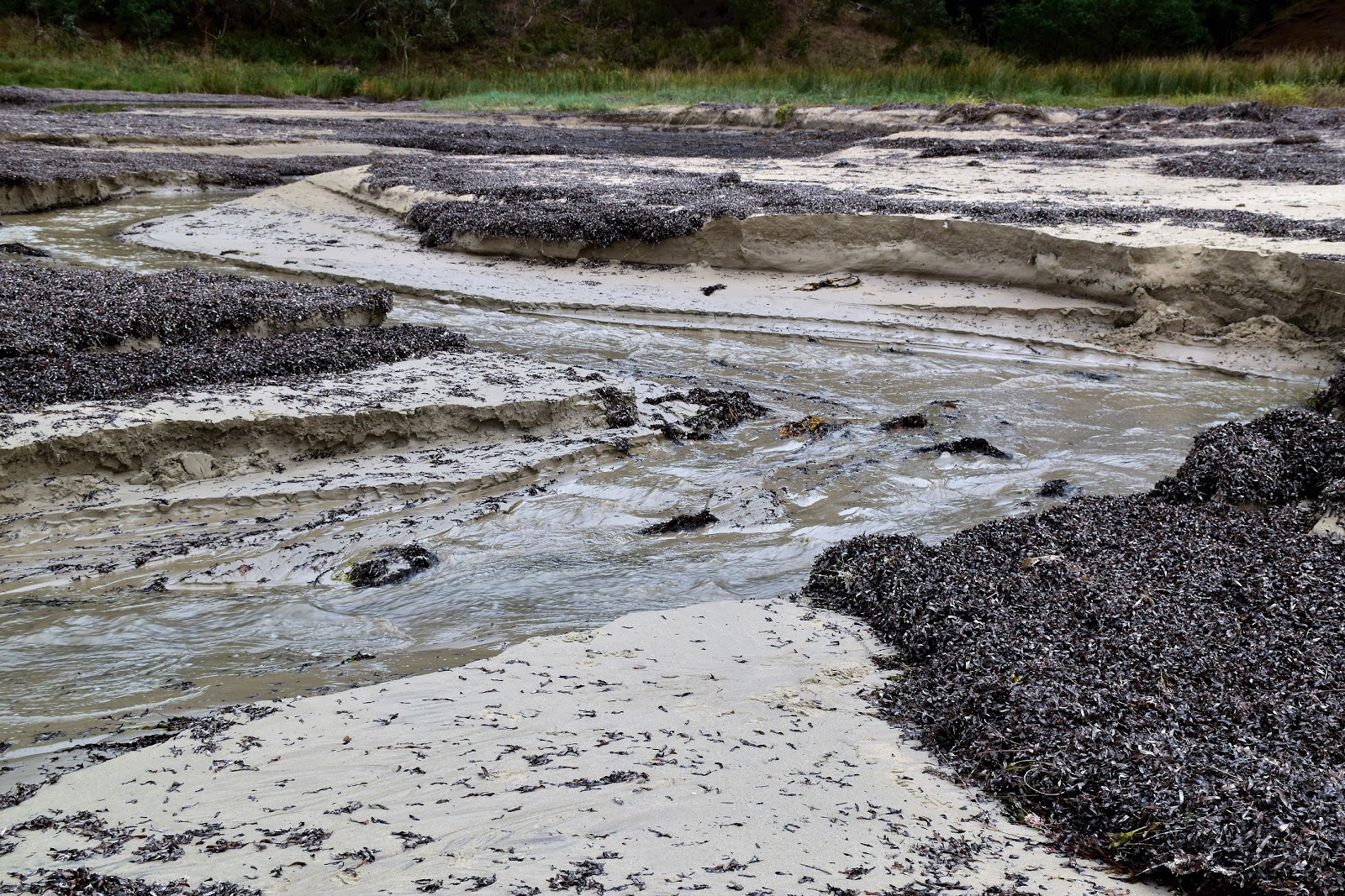
Pulling on my boots I dropped down onto the sand and set off on my journey along the coast towards Point Leo. With dead low tide about an hour away the beach walking was about as good as it can be really, the only real obstacles that I’d encounter were within the first five minutes after leaving the ute. The first obstacle that I had to negotiate was Stony Creek. Now at high tide after biblical rain this little creek might provide a bit of a challenge, but this morning though I was able to skip my way across barely getting my feet wet.
 |
Stony Creek was successfully negotiated with dry feet.
 |
It aways surprises me how close this section of the coast is to Phillip Island.
 |
Rounding the first point I was in more danger of falling into a rock pools than getting swept off the rocks by a rogue wave.
|
|
|
After crossing Stony Creek I soon arrived at the next spot that could potentially be an issue, I now had to get around a rocky point. Luckily with the tide being almost right out I was in more danger of falling in a rock pool as I explored the rock shelves than of being swept off the rocks by a rogue wave this morning. Whenever I walk down along this section of the Mornington Peninsula coastline I’m always surprised how close Phillip Island appears, and this rocky point and it’s rock shelves are probably the best spot to view the island on this walk I’m thinking.
 |
Grey and overcast...but at least it was mostly dry and calm.
 |
Beach combing between Shoreham and Point Leo, just after dawn.
|
|
After rounding the point I set off on my beach combing ramble north east to Point Leo, the sun now having risen high enough above the horizon that it was mostly blocked out by a fairly solid bank of grey cloud. There were basically two bays that I now walked around as I headed east, and the good news this morning was that both beaches were deserted. Now the reason both beaches were deserted is probably because it was still a fairly un-godly hour, the temperature was well down into the single figures, and serious rain was imminent, apart from that though everything was good!
 |
That's Point Leo in the distance.
 |
Point Leo
|
|
After numerous photo stops I eventually passed around the cliffs of Point Leo on the sand and suddenly I was sharing the beaches with a handful of surfers out enjoying the waves. Point Leo (otherwise known as Bobbanaring Point) is one of the Mornington Peninsula’s favourite surf breaks, the waves here generally being a little more forgiving than some of the other surf spots on the peninsula. Back when I was a Feral teenager I spent more than a few nights down here with my mates who surfed, although with this being a family rated blog (?) I can’t really go into too many details of those long gone days.
 |
Looking towards Merricks from Point Leo.
 |
Climbing up onto Point Leo I got some good views down towards Merricks, another section of coastline that I've walked.
|
|
After rounding Point Leo I climbed up onto the headland and wandered back through the campground, some of the early morning risers emerging from their wet tents blinking in the light. There are a few nice lookouts that are worth checking out along here, like earlier in the walk the main point of interest is the view across to Phillip Island, although this is also a good spot to check out the surfers who were bobbing in the ocean below me. Reaching a toilet block I headed back through the dunes and onto the sand again and turned right.
 |
These stairs basically represented the only altitude gain of the whole walk.
 |
Looking across to the Nobbies on Phillip Island.
 |
Point Leo
 |
Point Leo is a reasonably popular surfing break on the Mornington Peninsula.
 |
Time to head back to the beach.
|
|
|
|
|
Now I was back on the beach the rest of the walk was just a retrace of my outward route. Apart from a lone dog walker the beaches ahead of me are still deserted so I was more or less just following my boot tracks in the sand. I had a little good fortune shuffling my way back to the ute as well as the sun actually made a bit of an appearance a couple of times and with me now heading south west it meant that I was able to get some half decent photos.
 |
 |
Dropping back onto the sand overhead conditions had improved....
 |
....marginally!
 |
Beach walking again.
 |
Looking along the coast towards Shoreham.
|
|
|
|
|
Most of this section of coast is lined with foreshore camping zones but for the most part those campers are out of view from water level and the beaches feel surprisingly wild. Still I was a little surprised this morning to be entertained by a seal frolicking just off shore in the gentle waves, the seal was far enough off shore to make photographs a bit crappy but was close enough that I could easily watch its antics. Trudging on a bit further I passed by a gaggle of wild ducks floating in a sheltered bit of water. I was wondering if the ducks were down here due to it being duck shooting season as I’m thinking that salt water isn’t their natural habitat, although that’s a Feral Fact.
 |
The coast between Shoreham and Point Leo is a mixture of wide sandy beaches on these rock shelves (well at low tide anyway).
 |
I watched this Seal playing around for awhile. The Nobbies over on Phillip Island is a prime Seal watching territory.
 |
 |
I'm wondering if these guys are hanging out here to avoid the duck shooters.
|
|
|
|
Shuffling on, the red cliffs and Radiata Pine Trees of my last point were starting to get pretty close. I was pretty well switched off now though as I walked the last few minutes back to the ute, although the person swimming, sans wet suit at the Shoreham Beach got my attention for a few minutes. I’m obviously getting soft as I was keener to crank the heater up rather than jump into the icy water this morning. Safely back in the ute and heading home the rain that had been threatening me all morning arrived, yep things couldn’t have worked out much better really. My earlier melancholy now well and truly gone…a nice walk will do that though.
 |
The Radiata Pines more or less signify the end of today's walk.
 |
Mornington Peninsula coastal scrub.
 |
Looking along the coastline towards Flinders as I approached Shoreham Beach.
 |
Rounding the final point.
 |
The predicted rain was getting closer.
|
|
|
|
|
The Dirt.
I walked 7.6 kilometres and climbed 109 metres on this very easy stroll. Navigation wise things are also pretty easy, I just dropped down onto the beach at the Pines Carpark in Shoreham and turned left. Like most beach walks it pays to do this walk near low tide although I’m thinking that it would only be the highest of tides that may stop anyone completing this walk. If anyone want’s some published notes than the walk has more or less been written up by Ken Martin in his book
Walks of the Mornington Peninsula. To be honest though the Melways Map will see you safely through. This Westernport Bay side of the Mornington Peninsula is definitely the quiet side of the peninsula so if you want to escape the hustle and bustle of the busier areas then it’s worth considering a walk here.
Relevant Posts.
Point Leo to Balnarring, 2015.
Flinders Jetty to West Head, 2016.
Flinders Ocean Beach Walk, 2019.
 |
I'm guessing the green is something to do with the pine needles on the pine trees above the beach.
 |
There's a rough pad around the last point, if the tide is high.
 |
The Radiata Pines near the Pines Carpark in Shoreham.
 |
| Swimming at Shoreham a few days before winter...I don't think so! |
|
|
|
 |
Crossing back over Stony Creek my walk was over...and I was in a whole lot better mood than when I set off a couple of hours ago.
|


No comments:
Post a Comment