
I did manage to pull the DSLR out a couple of times. The Musgravea Walk utilises this old closed road for the complete distance so the walking is pretty easy.

Just walking from the ute to the picnic shelter required my trekking umbrella.

Sam headed off to the shops and I was alone...with the mozzies and the leeches!

Alright... it's time to head off.
Being a one way job (I wasn't keen on retracing my walk in the fairly average conditions) I asked Sam to drop me off this morning at the southern end of the walk at the Licuala Picnic Area. I decided to walk from here back up to meet Sam again at the carpark on the El Arish - Mission Beach Road as it meant that I'd get across North Hull River early on in the walk. I wasn't keen to get all the way down the walk only to find that I couldn't get across the river. Setting myself up under the picnic shelter in the Cassowary safe enclosure at the picnic area I watched as Sam splashed her way back out the access road and I was alone - with a million mozzies and leeches!

Initially the old road was almost level as I headed for the North Hull River.

Arriving at the North Hull River I was pretty happy to find the bridge well above the river height.
With the rain coming down hard there are only some pretty ordinary photos of this stroll, however I did give it a go, alternating between my DSLR, my phone and when things got even wetter I pulled out my waterproof camera. As I've mentioned I was keen to get across the North Hull River as soon as I could today and thankfully when I arrived at the river I found it still well below the bridge, at least now I was pretty certain that I would actually get through to meet Sam at the other end. Once across the river the old road started climbing very gently and it was now that the rain got torrential, double dry bagging all my electronics I splashed my way north trying to juggle my waterproof camera, my trekking poles and my umbrella, while at the same time picking off leeches and swatting away mozzies, yes all was good in my Feral world!


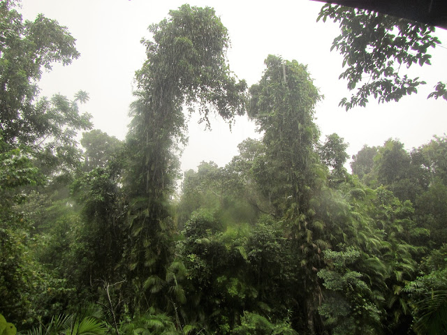
Actually there was one tiny positive with the rain, yes it seemed that when it got really heavy it got too much for the squadrons of mosquitoes to fly through and I actually got a bit of a break from the constant attack. I'd worn my trail runner today as I was pretty sure that I'd be getting wet... and I was right. I was now splashing along through ankle deep water as the old road had become a creek, at the same time I now had numerous small waterfalls cascading down onto the road from the rainforest clad slopes around me. After about an hour and a half of very wet walking I got to a spot where the canopy started to lighten a bit and suddenly I emerged from the jungle to find Sam parked and waiting for me beside the road. Needless to say it was with some relief when I climbed into the relatively dry and mozzie free ute and motored back into town to our accomodation.

North Hull River.

Conditions deteriorated fast now...

... so it was time to pull out the waterproof camera.

The Musgravea Walk, Djiru National Park.

We ended up spending 3 nights in Mission Beach and it didn't stop raining at any stage.

Good to know... but I'll give the bench a miss today.

Have I mentioned the rain?


With no landscapes to photograph I was looking for details on this walk.

The Musgravea Walk, Djiru National Park.

Towards the end of the walk the rain eased off a bit.

There was water cascading down through the forest everywhere now.
The Dirt.
According to my GPS I walked around 5.1 kilometres and climbed about 61 metres on what I'd call an easy walk. As I did today this walk is one to consider when conditions on the nearby beaches aren't ideal I think, being a rainforest a little rain isn't a bad thing. The other thing with this walk is that it is completely along an old closed road so for the most part I wasn't pushing through the scrub which also makes walking in the rain a little more enjoyable. The downside as I did the stroll today was that it was a one way walk so it needs a bit of logistical thought. This walk has been written up by a few walking guide book writers over the years, I used the notes and map out of Tyrone Thomas' old book 50 Walks in North Queensland World Heritage Wet Tropics & Great Barrier Reef along with my Alltrails App and my GPS topos today.
Relevant Posts.

Cassowary poo... this is as close as I got to one of the big birds today (last time I did this walk I did see some Cassowary's and from what I can ascertain they are still pretty common here).

Approaching the El Arish Road near the end of the stroll.

The light above the wobbly the distance is the northern trail head on the El Arish Road clearing.

Cowley Beach is the nearest BOM site - 234 mm in less than 24 hours is about the most rain that I've ever experienced I'm thinking.


No comments:
Post a Comment