 |
McKenzie's Jetty
 |
| Looking down over Lake Wabby on day three. |
|
This is another post straight out of the Feral time machine. These are my fading memories and photos of a walk I did on Fraser Island with Sam, Bel and Dave way back in 2002. Dave and I had been up climbing Mt Bowen on Hinchenbrook Island and had picked Sam and Bel up in Bunderberg on the way home, before stopping off at Fraser Island for a few days walking. This was my second multi night walk on Fraser Island, my first trip was a solo expedition a few years earlier which I’d enjoyed so much that I wanted to go back again, managing to talk the others into joining me on this visit. This walk was before the Fraser Island Great Walk was a glint in QLD Parks marketing department’s eyes, back in the day we largely followed the tracks that the Great Walk follows now days but the walk went by the catchy title of the Forest Lakes Hiking Trail.
 |
| We caught the car ferry over from River Heads. |
Day 1 Kingfisher Bay to Central Station 19.4 kilometres
After a short ferry ride over from River Heads we were deposited at the flash Kingfisher Bay Resort, although there would be no swish accommodation for us and after a quick pit stop at the bakery, we set off up our first sand dune as we headed towards Lake McKenzie. After the initial climb we followed the crest of a dune high above Dundunga Creek, the walking here, and more generally on Fraser Island, is easier than you may imagine sand walking would be.
 |
Turtle wrangling at Lake McKenzie.
 |
Lake McKenzie
|
|
Lake Mckenzie made a beautiful place for lunch and a swim today, although we weren’t the only ones who thought that, as it looked like all the back backers in Queensland were basking on the white sand. While Sam and Bel enjoyed the sand, Dave and I jumped in for a swim, with the crystal clear water home to a big population of small turtles it kept me interested for awhile. After lunch it was a matter of trudging through the back backers on the main beach in front of the day use area, then picking up the track at the end of the beach and heading over to Central Station, stopping at Basin Lake for some more turtle wrangling on the way. Central Station is an old logging camp and it made for a very comfortable camp, we even had hot showers! After stashing all our excess gear in the Dingo proof lockers we went for a bit of a late afternoon stroll up into Pile Valley to check out the old Satinay Trees and chill out a little in what must be as close a nature gets to a cathedral.
 |
Basin Lake
 |
Wanggoolba Creek near Central Station.
 |
The Pile Valley Walk is well worth doing if you find yourself at Central Station.
 |
| The Pile Valley Walk. |
|
|
|
Day 2 Central Station to Lake Boomanjin 14.6 kilometres 34.0 kilometres total
We had a fairly easy day in front of us today so took our time packing up and enjoying another hot shower. Eventually we set off towards Lake Boomanjin, the sandy track climbing a little initially as it passed through an indistinct forested saddle. Dropping down the track we passed by a series of beautiful perched freshwater lakes, firstly Lake Jennings which we caught glimpses of through the trees, then the large Lake Birrabeen and finally Lake Benaroon, who’s crystal clear water and white sand provided all the excuses that we needed to drop the packs and go for another swim. After a swim and lunch we shouldered our packs and headed off on the last 5.5 kilometres across to our nights camp at Lake Boomanjin. The most interesting section of the afternoons walk was when we arrived onto the northern shoreline of Lake Boomanjin, the walk around the stark sandy bed of the lake having a bit of a wild feel about it. Back when we did this walk we had to camp in a dingo proof enclosure with the 4wd campers although thankfully the camping area was almost deserted today, nowadays I think that the Great Walk punters have their own camp.
 |
| Lake Benaroon |
Day 3 Lake Boomanjin to Eurong 16.8 kilometres 50.8 kilometres total
We were quite excited when we left camp this morning, today we were heading to Eurong for the night which meant that we’d be able to have a hot shower and sleep in a soft bed. Initially we headed south along the sandy track for awhile, passing the turn off to the Sahara like Wongi Sandblow on the way. With the last few kilometres before we reached Dilli Village being gently downhill the walking was pretty easy this morning. Dilli Village marked the southern most point on our stroll and it also marked the start of a fair length of beach walking. Beach walking on the east coast of Fraser Island is generally pretty easy as the sand is fairly hard packed, but the walking is exposed though and this afternoon we suffered a bit in the heat. Taking our minds off the heat and our sore feet though were the Whales that were breaching just off shore, unfortunately it looks like the Whales were invisible to the 4wd’s driving up and down the beach, one of the advantages of travelling by shanks pony I suppose. Arriving at Eurong in the middle of the afternoon we did indeed enjoy our hot showers and soft beds……and hot food and cold drinks!
Day 4 Eurong to Lake McKenzie 19.5 kilometres 70.3 kilometres total
After our very comfortable night at Eurong we awoke to a bit of a dilemma today, glancing across the island in the direction that we’d be walking revealed plumes of smoke rising from the trees. Luckily for us there was a ranger station at Eurong, so after breakfast I moseyed on over to suss out the situation. Once the ranger picked his jaw off the ground after I’d told him we were bushwalking on the island, he told me that we’d have no worries making away across to Lake McKenzie this afternoon, ok everything was sweet then.
 |
Heading for Lake Wabby and towards the smoke.
 |
| We walked across that sand blow to reach Lake Wabby. |
|
Leaving Eurong we make our way to Lake Wabby this morning were we dropped our packs and enjoyed a leisurely swim and lunch, after all there was no real hurry with just a four hour forest walk ahead of us and we’d be at Lake McKenzie, no problems there. So it was after 2pm when we finally climbed steeply away from Lake Wabby only to almost immediately meet some tape starched across the walking track warning us of a prescribed burn in progress, for fucks sake! Our easy straightforward day wasn’t quite so straightforward now. With the smoke a fair way away and this area already burnt we pushed on before eventually coming to a 4wd track, here the walking track had more tape across it. Judging by the tyre tracks the 4wd track was still open though and as it was also heading to Lake McKenzie we figured that the safest option would be to trudge along it.
 |
Dave, Sam, Bel and some Feral looking bloke at the somewhat smoky Lake Wabby lookout.
 |
| Lake Wabby |
|
Twenty minutes or so after starting along the 4wd track we arrived at a queue of 4wd’s and some very stroppy rangers. Letting us know that we shouldn’t be walking here, I replied along the lines of ‘no shit Sherlock, that’s why I went out of my way to check out the situation with the rangers at Eurong’. Needless to say my reply didn’t fill them with anymore good cheer. After a bit of negotiation we managed to jump into the back of a 4wd that was heading for Lake McKenzie and we were soon at the deserted camp, we’ll actually there was a school group and a couple of other walkers camped there but it was about as deserted as Lake McKenzie gets.
 |
The ranger wasn't very happy to have us at Lake McKenzie tonight.
 |
Lake McKenzie
 |
| Last time I was on Fraser the turtles had gone......I'm hoping I was there at the wrong time of the year and it's not a bigger issue? |
|
 |
| Lake McKenzie |
 |
| The deserted Lake McKenzie looked pretty eerie in the smoke this afternoon. |
|
Day 5 Lake McKenzie to Kingfisher Bay 12.7 kilometres 83 kilometres total
Our last day on the island was originally meant to be a retrace of the first half of day one but the prescribed burn had changed all that, with that track closed we headed out along a 4wd track before picking up a lesser track that dropped down an old tramway to McKenzie Jetty. After a bit of a break at the old jetty we set off up the beach towards Kingfisher Bay. Now days there is a track cut inland along the cliff tops for the Great Walk and I know why they cut it, this section of beach had to be some of the softest and deepest sand that I’ve ever walked. After slogging our way the last three kilometres or so up the beach we were somewhat relieved to arrive at the day use area at the resort and chill out for a bit while we waited for the ferry back to River Heads.
 |
Next morning at Lake McKenzie, the smoke had gone.
 |
Bel, enjoying the winter's sun at Lake McKenzie.
 |
It's a rare thing to find the beach at Lake McKenzie deserted on a sunny day.
 |
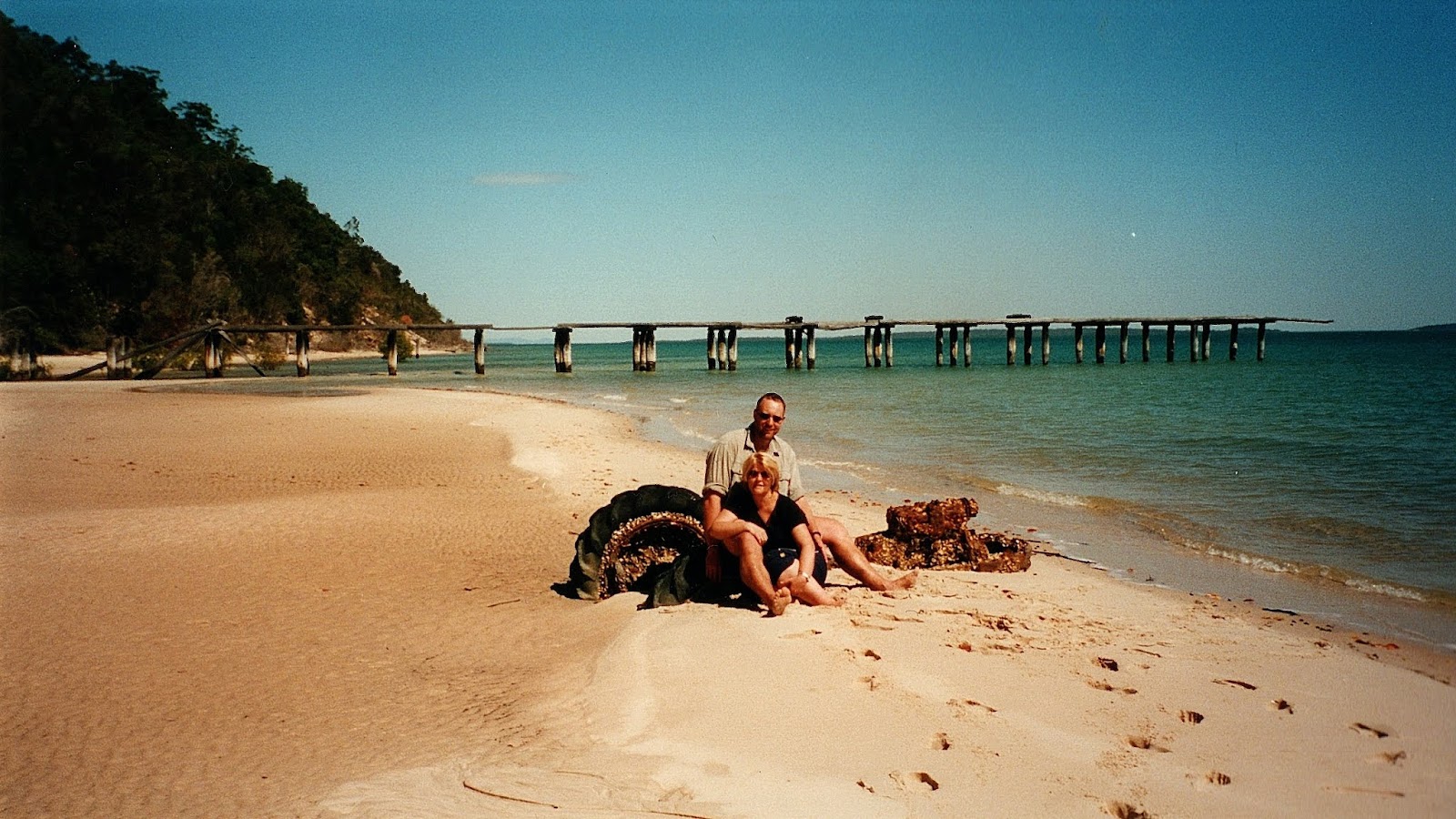
McKenzie Jetty
 |
| This old tractor had seen better days. |
|
|
|
|
The Dirt.
We walked around 83 kilometres on this walk. I’d rate the walk as we did it as a Medium grade walk I think. Back in 2002 the tracks and camps were nowhere near as flash as they are now that the walk is known as the
Great Walk Fraser Island. Having said that, things weren’t overly tough, the main section that was way harder back then was the final slog up the very soft beach back to Kingfisher Bay, the new inland track is a lot easier along this section, although it’s a little longer as well. Back when we did this walk we used a Hema Map I think but mostly relied on the map and notes out of the last edition of Lonely Planet’s ‘
Bushwalking in Australia’ that was written by John and Monica Chapman.
Relevant Posts.


No comments:
Post a Comment