 |
| Sun's coming up...time to get on with life. |
After spending the previous night watching Labor snatch defeat from the jaws of victory at the pub, I was in a bit of a melancholy mood this morning. Luckily though by the time I’d had a nice long hot shower, a decent breakfast and packed up my mood had lifted a bit, there’s another election in 3 years hey. I guess the planet can wait, grrr! Oh yeah and no one is going to take away my ute (whadya mean that was bullshit too!). And I reckon I play pretty fast and loose with the truth! Anyway, enough social commentary it’s time to start walking.
 |
I still seem to have carried an inordinate amount of crap on this walk.
 |
| Sunrise from The General. |
|
It was just after 8am this morning when I emerged from my room blinking into the new day, the forecast for today had been for increasing cloud although from the look of it there wasn’t a lot more it could increase, things were fairly overcast. Oh well, a melancholy mood matches a melancholy day. Instead of heading back up to Hotham Heights along the Great Alpine Road this morning I decided to change things up a bit and walk along Higgi Drive, my walk basically paralleling the Great Alpine Road 30 metres higher up the hill.
 |
There were even a few little patches of lingering snow.
 |
The view over to Mt Loch off Higgi Drive.
 |
| Higgi Drive...well it was better than walking the Great Alpine Road I suppose. |
|
|
Dropping back down to the Great Alpine Road at Hotham Heights I almost immediately left the road again, now I was climbing up beneath the Summit Chairlift. Like I mentioned yesterday, if you can block out the dormant, creaking skiing infrastructure these open grassy tops make for fairly good walking. Shuffling up towards the summit this morning my eyes were drown to towards both Mt Feathertop and Mt Bogong, the flanks of both mountains having a very light coating of snow (or maybe it was frost?). After shuffling my way up to the summit I dropped my pack for awhile for a bit of a break, with a fair chunk of Victoria’s High Country being visible from up here it’s not a bad spot for a stop, so long as the weather is co-operating.
 |
I headed up to the summit under the Summit Chairlift.
 |
The open slopes allow for some great views....that's Bogong in the distance....
 |
....and that's Feathertop, a little closer at hand.
 |
The Great Alpine Road wasn't far away.
 |
Mt Hotham Summit.
 |
| I was still (just) managing to crack a smile this morning. |
|
|
|
|
|
Suitably well rested after my break on the summit I grabbed my pack and set off again, in theory it was all down hill from here! Firstly I dropped down to Diamantina Hut before striking out across The Razorback. The Razorback is one of the more well known walking tracks in Victorian bushwalking circles and it makes for a scenic and relatively easy way to access what is arguably our prettiest alpine mountain, Mt Feathertop. I wasn’t going all the way across to Feathertop this morning but I was still doing a fair chunk of it, my plan now was to follow the track to near Twin Knobs.
 |
Dropping down to Diamantina Hut I got a nice look at Mt Buffalo.
 |
In good conditions navigation is pretty easy dropping down to Diamantina Hut, in bad conditions....well you really don't want to be here!
 |
| The sparten interior of Diamantina Hut. I wonder who thought that it was a good idea to put a rubbish bin inside? |
|
|
Having come up Bon Accord Track yesterday in the sun and got some great views there was no real incentive to climb and descend the Big Dipper in this mornings overcast conditions, so instead I picked up the pad that sidles the eastern side of the high knoll. This is actually a pretty good section of track I think, the pad being cut into some very steep slopes and the views across the headwaters of the Diamantina River towards Mt Loch are pretty good. When the two pads re-join north of the Big Dipper the track pretty much follows the crest of The Razorback for awhile, initially above the tree line before losing a bit of height and heading through some alpine scrub and Snowgum regrowth. Of course it goes without saying that after losing height I then climbed again to the spot where I’d drop off The Razorback, at around 1700 metres elevation I was now only around 150 metres lower than today’s high point back at Mt Hotham.
 |
By-passing the Big Dipper on the Razorback Track - there is a reason that this track is very popular.
 |
Looking back towards Mt Hotham from the Razorback.
 |
The first three or four kilometres along the Razorback are mostly above the tree line...
 |
....and then I dropped into some scrubby Snowgum regrowth for awhile.
 |
| Looking back along the Razorback towards Mt Hotham, my day was about to get a bit harder. |
|
|
|
|
Where as my day so far had been pretty cruisey, things were now about to get real as I dropped down Champion Spur. Looking for the spot where The Razorback Track suddenly swings from north-south to east-west just before Twin Knobs I dropped off the ridge to the west. After consulting my map and GPS I was able to take a bearing on a knoll a bit further down the spur, the reasonably open Snowgum country making navigation fairly strait forward. Once I dropped down spur a bit navigation got even easier as Champion Spur got a little more acute. The even better news than the navigation being pretty strait forward was that the regrowth wasn’t too much of an issue, initially at least.
 |
The Razorback Track does a right/left zig zag here, I dropped off the side just before the line of Snowgums on the crest of the ridge in the middle of the photo.
 |
| The top of Champion Spur was open enough that I could navigate by line of sight. |
 |
| Once I was on the correct spur navigation was even easier. |
|
When I’d attempted to climb Champion Spur last year I lost the old overgrown fire track at around the 1200 metre mark so I figured that at worst I had to drop down that far before I’d once again find the old track. On the flip side side I’d heard a rumour that Parks Vic had run a bull dozer up the old fire track and if that was the case then maybe I wouldn’t have to scrub bash as far down as I’d feared, time would tell I suppose. Anyway downward progress was still being made, and made surprisingly easily actually. I was able to pick up a few random deer pads that were generally heading in the direction that I needed to go and with a bit of planning and a bit of luck I was able to avoid the worst belts of scrub.
 |
Dropping down a bit the scrub got a little thicker...but wasn't too bad really.
 |
| The spur gets very acute in one spot. |
|
After crossing over a couple of nice, relatively open knolls and walking a short section of knife edged ridge (complete with a very old cairn which apart from a couple of cut logs was the only real sign that people had been this way before - well until I met the fire track anyway) I was starting to get a bit cocky, thinking to myself that this off track walking is pretty easy. Hmm, what could go wrong? Reaching a relatively level section on the spur I checked out my GPS, less than 200 vertical metres to descend before I’d get to the spot where the fire track disappeared last year, yep I could almost taste that cold beer waiting for me at home. Of course being a Feral walk things now turned all Burke and Wills on me, this level section was covered with Alpine Ash regrowth and while the regrowth itself wasn’t too bad to push through, the hundreds off fallen dead trees littering the ground at random, leg breaking angles were a pain in the arse.
 |
Hey, hey, I even found an old cairn.
 |
| Just before dropping down into the worst of the scrub I crossed this nice little knoll. |
|
After a couple of hundred metres of very rough, slow walking I’d reconciled in my mind that the beer would be staying in the fridge tonight and I’d be lucky to get home in time for a hot chocolate before bed. I was walking a few metres, stopping to scope out the path of least resistance, walking a few more more metres and repeating the exercise again. It was on one of these stops when I was staring at the jumble of fallen trees on the ground that I noticed something very unusual, one of the dead fallen trees had a chainsaw mark in it? Raising my gaze off the ground I had another Burke and Wills moment, although instead of finding the Dig Tree I found a freshly bulldozed fire track, sweet…like I was saying how easy is this off track walking caper, hey?
 |
Heading into the Alpine Ash regrowth slowed me down a bit, although the biggest issue was the dead trees littering the ground.
 |
I dropped a little too far off the west side of the spur in one spot, getting back onto the crest wasn't very pleasant.
 |
| Hmmm, what's this I spy? The old fire track has been pushed around 150 metres higher up the spur than from when I up here last year. |
|
|
I’d met the track at the 1360 metre contour this afternoon which was around 100-150 metres higher up the spur than the spot it had disappeared when I’d climbed up here last year, not only did the track get higher up the Champion Spur but unlike last year it was totally free of scrub. Setting off down the fire track I had another piece of good fortune too, with the track being fairly recently bulldozed the surface was pretty soft which meant that the descent was fairly painless on my ageing knees and ankles (my quads on the other hand were seriously sore for the next few days).
 |
Dropping down the spur things were very easy now.
 |
Champion Spur fire track.
 |
| Dropping down the fire track wasn't without it's scenic highlights. |
|
|
Less than an hour after stepping foot on the cleared fire track I was wading across the Ovens River East Branch and that celebratory beer was again on the cards. As with the fire track up Champion Spur the old fire track along the Ovens River East branch was also freshly bulldozed, although I guess that makes sense as how else were they going to get a bulldozer in here. When I’d walked this section last year the track was for all intents and purposes gone, I’d shuffled my way back to Harrietville either in the river or following the occasional piece of flagging tape. This afternoon though navigation was not an issue and while I still had to wade the Ovens River East Branch more than ten times (I lost count) it was a very easy way to finish of the walk.
 |
It's a steep climb/descent.
 |
I'm almost down at the Ovens River East Branch. Last time I walked this section of track I was weaving through saplings growing out of the old fire track.
 |
| Thankfully the old fire track has also been cleared along the river as well (it only makes sense I suppose, how else would of they got the bulldozer onto the spur!). |
|
|
There’s a lot of old gold mining history around Harrietville and the walk down the river has it share of clues to the past in the form of water races and mullock heaps. Speaking of the gold mining history though I’m always a little dubious of the water quality in this river, there are some dams along here that have a district yellow colour about them and some of the creeks running into the river also flow with that rusty, oily yellow colour. Not to worry, I didn’t need a drink this afternoon anyway. Less than half an hour after wading the river at the bottom of Champion Spur I was once again wading the river, only now I was back at the Bon Accord Track Head. Climbing away from the river up to the ute I had time for a quick bush shower before pulling on some clean clothes and setting off on the 5 hour drive home.
 |
Last time it was sometimes easier to wade the river, now it's a doddle to stay on the old track(for a few years anyway).
 |
The walk down the valley is pretty nice.
 |
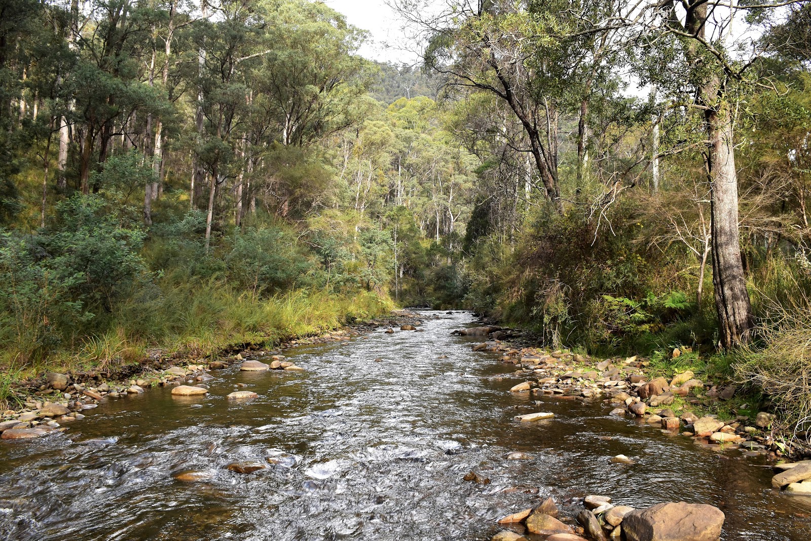
The Ovens River East Branch.
 |
| There are some old tailings dams and quite a few mullock heaps along here. I'd be careful if drinking the river water. |
|
|
|
The Dirt.
According to my somewhat recalcitrant GPS I walked 19.9 kilometres and climbed 505 metres on what is a fairly hard days walking. The 505 metres of climbing was ticked off before I dropped off The Razorback, once dropping down Champion Spur there is bugger all climbing left to do. If anyone wants to do Champion Spur then I’m thinking the next couple of years are the go, before the fire track becomes overgrown again. The worst of the regrowth is is through some Alpine Ash and it only lasts for around 200 metres now, that 200 metres took me around 20 minutes to negotiate though. I used the Rooftop Bright-Bogong-Hotham Forest Activities Map along with my GPS maps on this stroll.
Relevant Posts.
Champion Spur, Alpine National Park, 2018.
The Twins to Mt Hotham, AAWT, Alpine National Park, 2017.


No comments:
Post a Comment