 |
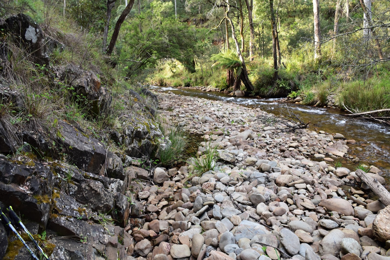
| Ovens River East Branch |
By mid afternoon I knew I was in trouble today, for the last hour my quads and groin had been randomly cramping causing me to quickly jettison my pack while I writhed around on the ground trying to massage away the pain. Now normally writhing around on the ground massaging my thighs and groin would be a positive thing, however seeing that I was half way up a bloody steep spur, on a stinking hot afternoon, pushing through a wall of regrowth with my only company being an army of ants that took no time getting to know me every time I hit the ground, things weren’t so flash!
My day hadn’t started off too badly, I’d left home around 4 am arriving at the start of the walk at Harrietville before 9am. This was meant to be day one of a four day walk up to Mt Feathertop and then over to the Bogong High Plains before dropping back down to Harrietville again. I knew that today was going to be the crux of the four days though, as instead of taking one of the well trodden spurs up to Mt Feathertop I was going up Champion Spur. Champion Spur is a route that was used a bit in the ye olde days to reach the middle sections of the Razorback. However in the last 10 years or so a huge fire, closely followed by a large flood has altered the conditions up here a lot….how much the conditions had altered I was interested to find out.
Before I’d even set off today I had a couple of things going against me, first of all it was going to be stinking hot which meant that shorts and gaiters quickly became the the lesser of the two evils. I was figuring that the scratches would heal, but cooking myself in long pants on a 36˚ day would definitely stop me before I could complete what is an 1100 metre climb onto the Razorback near High Knobs. The second thing working against me today was that I’d decided to carry my old canvas Macpac Cascade pack, this old beast would be bomb proof when it came to the scratchy scrub but it came at the cost of extra weight, I reckon the old pack must weigh 4 kilograms before I even think of loading anything in. Oh yeah, there was a few other things working against I suppose, yep, I’m old, fat and unfit. But apart from all that everything was sweet!
 |
| Leaving Harrietville things started off promisingly enough. |
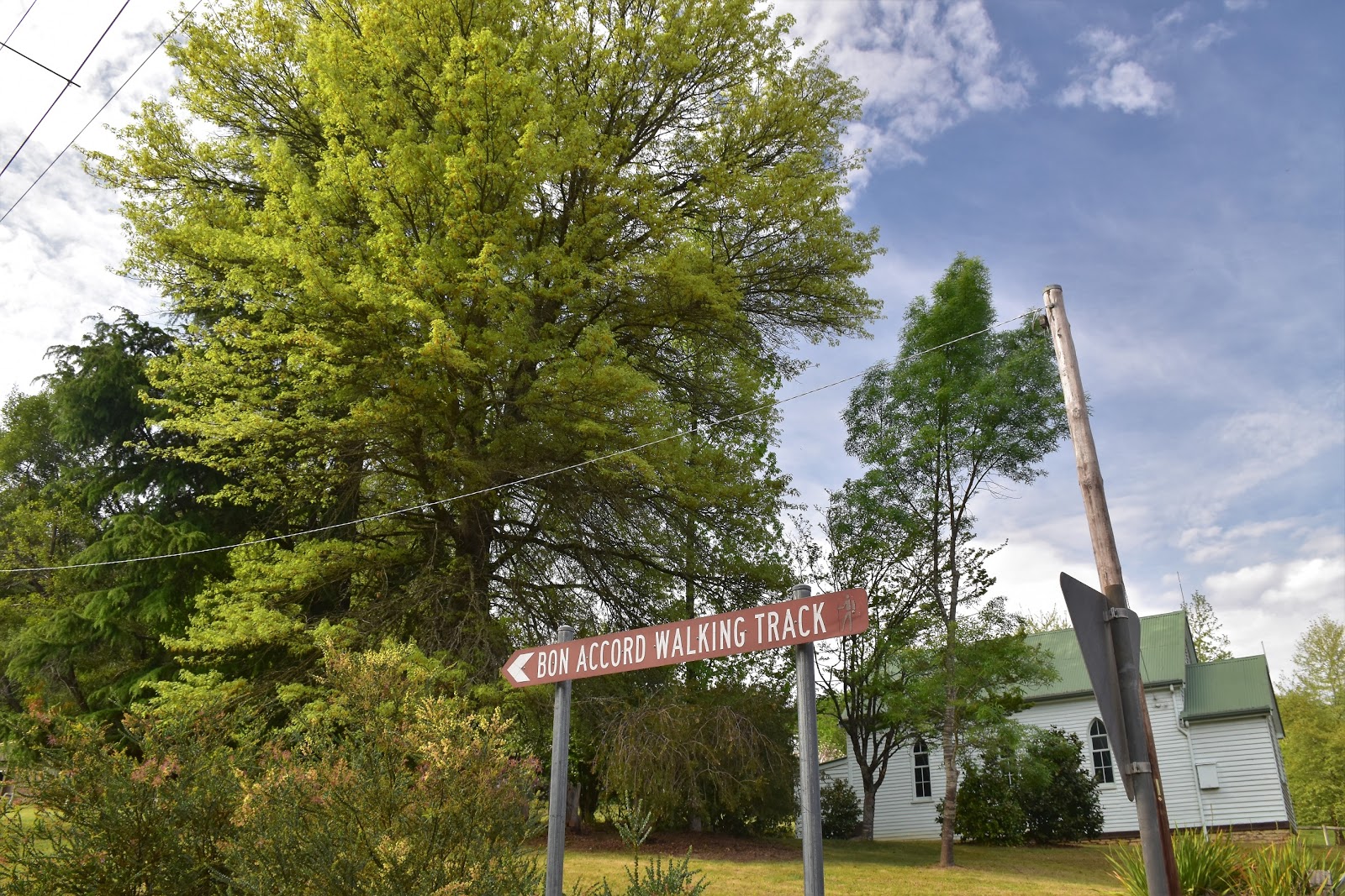
Parking at the picnic area at the Hotham end of town I meandered my way through the back streets of Harrietville for a few minutes before arriving above the Ovens River East Branch. After walking a quiet dirt road for a few hundred metres I arrived at the Bon Accord Walking Track trailhead. I had a decision to make here. I could take the old Champion Spur Track which I knew involved 13 crossings of the river and I suspected would be rough, indistinct and overgrown, or I could take the Bon Accord Walking Track which contours above the west bank of the river and then drop down and pick up the Champion Spur Track at the 13th crossing. I chose the Bon Accord Walking Track this morning.
 |
Wandering through the back streets of Harrietville it was easy enough to find the trailhead.
 |
| The Bon Accord Trailhead. |
|
After half an hour or so of pretty easy walking along Bon Accord Walking Track I arrived at the spot where I had to drop down to hopefully intersect with the old Champion Spur Track….and that was the end of the easy walking for the next 7 hours. Dropping off Bon Accord Track I crossed an old water race (there is a lot of old gold mining history buried in the scrub around Harrietville) and made my way steeply down a spur. I got a little lucky descending down here as I picked up what must have been an old bulldozed firebreak, the old firebreak having slightly less scrub to push through than the surrounding bush. Twenty metres or so above the Ovens River East Branch the old firebreak disappeared and I pushed the last few metres through blackberries and other assorted scratchy scrub to the river.
 |
There was a little bit of wildlife out and about in the sun on Bon Accord Track this morning.
 |
Bon Accord Track
 |
Looking across the valley of the Ovens River East Branch towards Champion Spur and the Razorback from Bon Accord Track.
 |
OK, here we go! I'm dropping off Bon Accord Track to cross the river and hopefully intersect with the old Champion Spur Track.
 |
| Dropping down here I was lucky enough to pick up this old, overgrown firebreak. |
|
|
|
|
Arriving on the scoured out river bed I was hoping to see the Champion Spur Track crossing it for the last time, instead I saw a 1 metre high eroded river bank that I needed to get up, hmm. My first issue was to get across and out of the river though, I could find the old fire track once I was on the other side. Walking up stream 50 metres or so I found a shallow spot that had a reasonable exit that wasn’t too steep and without an impenetrable wall of blackberries to negotiate, all good. Managing to get across the river with more or less dry boots I set about finding my elusive fire track. Looking at my map I figured that the track would be climbing across the spur in front of me before it reached the crest so I decided that heading straight up should see me intersecting with it. Thankfully my navigation was going OK today as I wouldn’t of wanted to climb much higher up this steep scrubby spur before meeting the old track, as it was the 20 metres or so that I did climb almost killed me.
 |
I crossed just up stream at a spot where the blackberries were a little more manageable.
 |
| The short sharp climb onto the old Champion Spur Firetrack almost killed me....my legs were already looking a bit second hand! |
|
So I was now on my track, all I had to do now was to follow it up the spur towards the Razorback, according to my map the fire track use to stop at around the 1450 metre mark which should leave me a couple of hundred metres of scrub to push through until I emerged onto the open tops of the Razorback. Hmmm, anyone see where this is going? You may be shocked, but straight up I had my doubts. The old Champion Spur Track was fairly overgrown even down here, I was climbing through a small forest of saplings growing out of the old track. Not to worry, upwards progress was now being made. After weaving my way through this band of saplings the climb actually got a little better, the saplings gave way to low scrub and while it was bloody prickly, it was easy enough to plough through it.
 |
The old firetrack was navigable down here.
 |
Once on the crest of the spur I started to get a few longer distant views.
 |
| Climbing up the crest of Champion Spur the old track was still reasonable. |
|
|
While the scrub wasn’t overly tough, the climb was fairly unrelenting and I was already ringing wet with sweat, I’d left the river with 4 litres of water but couldn’t fill up again until tonight when I’d hopefully make it to Mt Feathertop, well that was the theory anyway. After cutting across the nose of the spur for awhile the track suddenly turned north east and started to climb the crest of the spur, now seriously steep. Still the good news was that the old track was still easily followable, well I am a glass half full kind of guy. It was worrying me a little how often I was stopping for a drink though, trudging upwards I was trying to keep the drink stops down to one every half an hour but judging by the amount that I was sweating there was no way I was replacing what I was losing.
 |
The Razorback still looked a fair walk away.
 |
| I was pushing through this waist high scrub for awhile, the track was still followable at this height. |
|
Shuffling up through the 1000 metre mark the spur changed direction and started to head easterly, it was shortly after this that the regrowth started to get pretty serious. By the time I’d climbed to the 1150 metres mark all evidence of the old fire track had gone and I was pushing through the scrub staying on the highest ground. With the walking now fairly gymnastic as I climbed over fallen trees and pushed through various different bands of head high unsociable flora it was now that my thighs start to cramp, fuck! Thankfully I had some Gastrolyte in my pack so that kept me going for a bit longer but by the time I got to around the 1300 metre contour I knew I was cooked. I still had about 1.5 litres of water but I was guessing that I still had at least another 300 vertical metres of regrowth to negotiate before I’d make open ground, once on the Razorback I was still looking at an hour or two over to the spring on the North West Spur Track beneath Feathertop.
 |
Looking across to the Razorback and the top of Bon Accord Spur.
 |
The old fire track is was buried under fallen trees and regrowth, it was hard work clambering over these fallen trees, this is where my quads started to cramp up.
 |
Pushing through this scratchy stuff is probably the worst conditions to walk through.
 |
| Pushing through this stuff wasn't too bad, although it wasn't doing my hay fever any favours this afternoon. |
 |
| Hitting this Alpine Ash regrowth at around the 1250 - 1300m metre mark finished me off today, it was taking too much energy and water to push my way up through the head high scrub. |
|
|
|
Once I’d made the decision to retreat I didn’t muck around much, it was around 3 pm but it wasn’t the time that was worrying me now, it was the fact that I couldn’t walk more than 15 minutes without my legs cramping. To cut a long boring story short I made it safely back down to the river (obviously!), I even had a few millilitres of water left. Rather than retrace my mornings route and climb up onto Bon Accord Track I followed the old Champion Spur Track all the way down to the river, arriving at the river the old track more or less disappeared though. Noticing a couple of pink flagging tapes I waded downstream a couple of minutes until I found a log and a shady spot, dropping my pack I sat and enjoyed a very welcome drink and a couple of energy bars.
 |
Back down at the river it was time for a long, cool drink and a bit of a break, those prickly bushes had given my legs a hard time.
 |
The view from the log that I was resting on was pretty sweet.
 |
| Late afternoon heading downstream along the Ovens River East Branch....if you look closely you can see a piece of the pink flagging tape marking the old fire track. |
|
|
Actually apart from the pain in my legs this was a pretty nice spot, which was just as well as I suspected that I’d be spending a fair bit of time in the river rather than beside it. It was after 6pm when I finally figured that I’d better get going if I wanted to get back before dark. Like I suspected the old fire track has almost totally been reclaimed by nature along the river although someone has recently placed some flagging tape along here. Paying a fair bit of attention I more or less managed to follow the alignment of the old track, every now and again I’d find a hint that there used to be a vehicle track along here but more often than not it was a matter of heading downstream along the path of least resistance, the post fire floods have certainly done some serious remodelling down here.
 |
Sometimes I found it easier wading the river for short stretches.
 |
Ovens River East Branch
 |
| Late afternoon on the Ovens River East Branch. |
|
|
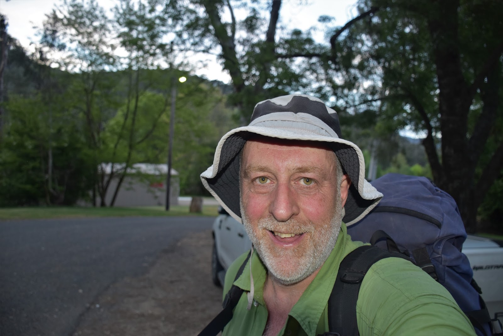
After one last wade down the river I noticed the Bon Accord Track information shelter on the bank above and then after one last scrub bash I pushed through a belt of blackberries onto the open ground next to the shelter. After signing out of my walk three days early, I retraced this mornings walk through the back streets of Harrietville and arrived at the ute just before dark. I’d been up and going before 4am this morning and I didn’t arrive back at Chateau Feral until after midnight, have I ever mentioned that I’m getting too old for this stuff?
 |
Walking the river had a few hazards.
 |
The post fire floods have really done a remodelling job down here.
 |
| There was a bit of a pad to follow in spots. |
|
|
The Dirt.
According to the GPS I walked around 19 kilometres today and climbed 1012 metres on what was a bloody hard day out. Champion Spur is probably doable for me, but in hindsight trying it on a stinking hot day (it got to 36.6˚ today in Wangaratta according to the BOM) with a full pack and pushing up hill through the dense regrowth mightn’t have been the smartest decisions…who knew hey! I’m thinking I might have another go next Autumn walking down the spur, although navigation will be tricky. I used Rooftop’s
Bright - Dartmouth Adventure Map on this walk. Tyrone Thomas and Glenn Van Der Kniff have also written notes about Champion Spur but things have changed so much on the ground since the fires and floods the old notes are of limited use really.
Relevant Posts.
Mt Feathertop, Alpine National Park, 1990.
North West Spur, Mt Feathertop, Alpine National Park,1999.
The Twins to Mt Hotham, AAWT, Alpine National Park, 2017.
 |
| Plan B turned out to be a lot more relaxing than today...I spent a couple of days up at Mt Hotham with Sam. |
 |
| Back at the ute, it had been a long, hot day! |


Thanks for the great read, I just managed the Champion Spur in the snow yesterday. The track looked recently cleared for a big chunk, but at about 1200m the regrowth and fallen trees hit with a vengeance! A late start meant it was totally dark at 1400m and the last push to the razorback was easily the worst slog I've ever done. A very slow walk following footprints by torchlight along the razorback and I was at federation hut at 9:30. It really is a tough one!
ReplyDeleteYeah, I came down it a couple of weeks ago. The track has had a bulldozer up it very recently and gets a fair way higher up the spur than it did on this visit. That's a big day you did, especially in the snow, you must of been pretty wet too, I'm thinking you would of been very happy to arrive at Federation Hut that night! Incidentally it took me just less than 3 hours to get from the Razorback back to Bon Accord Track Head going down Champion Spur so I think that is probably the way to go? I'll put a post up in the next couple of weeks about my walk down Champion Spur. Thanks for checking out the blog:)
Delete