 |
| The deserted Injidup Beach first thing this morning. |
My night of luxury at Canal Rocks had been just what I needed I think, I awoke this morning feeling pretty good again. A comfortable nights sleep, a shower and a good feed will do that I suppose. With another stinking hot day forecast I was out the door and on the track fairly early again today, shuffling my way south just after 6am. Thankfully with the Cape to Cape running straight past the front door of my accommodation I didn’t have to many extra metres to go to re-join the track.
 |
Canal Rocks Beachfront Apartments - I was very happy to have re-charged the body here last night.
 |
| After around 100 metres the C2C started to pass through these beautiful rocks. |
|
Reaching the end of Smiths Beach Road the C2C starts climbing up through a collection of jumbled red boulders, this section of the track is a little rougher and less defined than some of the other sections on the C2C but I really enjoyed it. Following a series of rough pads, cairns and marker poles the track climbed through the red rocks which were looking good in the early morning light. Reaching the top of the climb the views south towards Canal Rocks opened up ahead of me, the walking now fairly easy as I meandered my way through the low coastal scrub to cross Canal Rocks Road.
 |
Heading for Canal Rocks - if you look closely you can see a C2C marker post.
 |
I was climbing up this steep gully to the left.
 |
I'd got another sensational day of weather - although it was a little on the hot side.
 |
Looking down towards Canal Rocks.
 |
The C2C burrowing through the Tea Tree - I was already enjoying the shade.
 |
The C2C climbing up to the Canal Rocks Lookout.
 |
Canal Rocks
 |
Looking north up the coast towards Yallingup from the Canal Rocks Lookout.
 |
| I was already looking forward to a swim. |
|
|
|
|
|
|
|
|
Crossing Canal Rocks Road the C2C starts another interesting section of the walk which features the usual great coastal views and also a nice section where I climbed through a small cliff line on some handy stairs. At the top of the stairs I arrived at Rotary Lookout and it was time to drop the pack for the first of many times today while I savoured the view out over Canal Rocks to the Indian Ocean, stretching away towards Africa. Shortly after leaving the Rotary Lookout the C2C arrives at another lookout shortly before dropping down to cross Wyadup Brook, this lookout featuring views south over the stunning white sand of Injidup Beach down to the bare dunes on Cape Clairault, my next objective.
 |
Dropping down towards Wyadup Brook.
 |
That's Cape Clairault in the distance.
 |
The coastline near Wyadup Brook.
|
|
|
Before I could stand on the white sand of Injidup beach though I had to lose most of the height that I’d gained by dropping down a long series of steps to cross the dry Wyadup Brook. Climbing out of Wyadup Brook the C2C passes beside some rural land, quite an unusual occurrence on this walk, before climbing up to meet Wyadup Road on a headland. It was along here, while walking through some long grass that abutted the farmland that I had my first snake encounter of my C2C walk, although with walker and snake both heading in different directions at a quick rate I didn’t mange to get a photo. Crossing over Wyadup Road I started a fairly long cliff top traverse, the shimmering white sand and turquoise water of Injidup Beach seeming to taunt me below the cliffs before I eventually set foot on the sand around Mitchell Rocks.
 |
Crossing Wyadup Brook the C2C passes close to some farmland, a quite unusual occurrence on the C2C.
 |
The C2C follows the cliff tops for awhile....
 |
....before it eventually drops down to the sand.
 |
Injidup Beach - quite a stunning piece of beach side real estate!
 |
| Injidup Beach |
|
|
|
|
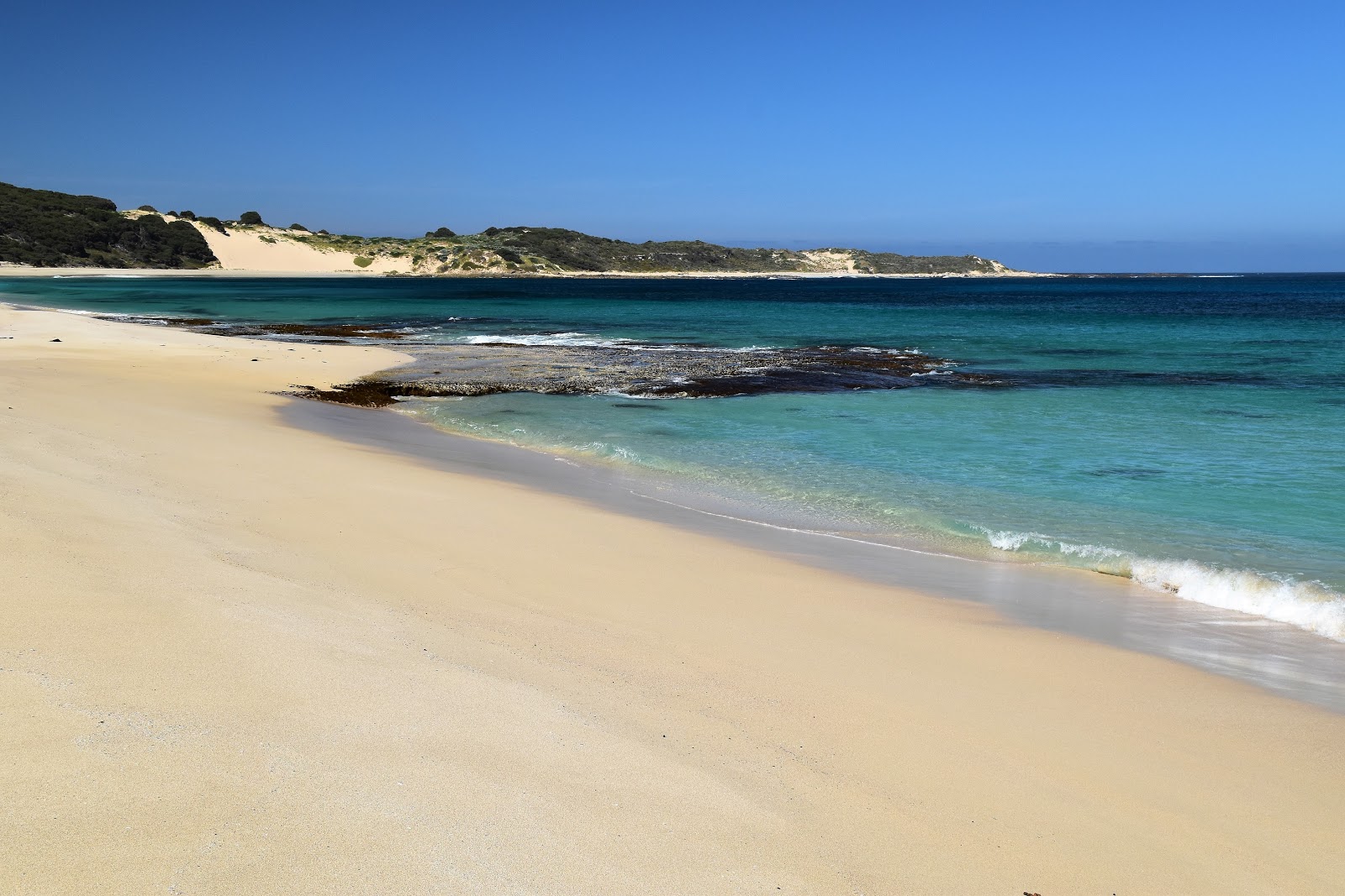
Once on the sand though I started to wish that I was back up on the cliff tops, whilst looking top shelf this beach was a tough slog for me this morning. Still I had a plan for a swim which kept me trudging my way south. Reaching the southern C2C exit off Injdup Beach (just before the bare dunes of Cape Clairault) I dropped my pack under the shade of some Tea Tree, stripped off and jumped in. Being only around 8am I was lucky enough to have this beautiful spot completely to myself, not something that is that common in the summer months I’m guessing. Now if there is anyone reading my waffle and thinking that all these swimming spots I talk about look ideal, then you need to consider your own ability in the water, none of the spots that I swam at along the length of my C2C walk were patrolled by lifesavers, on top of that the coastline is pounded by big swells which produce big rips….and then there is the Great White Sharks…all I’m saying is to be careful and don’t over estimate your ability. For me Injidup Beach is a great one for swimming as the ocean floor drops away very quickly and I was soon bobbing about just beyond the shore break only 10 metres or so from the beach.
 |
Injidup Beach
 |
Injidup Beach
 |
The tracks of the rarely seen Feral Sloth.
 |
Time for a swim.
|
|
|
|
With some reluctance I eventually emerged dripping from the water and started preparing for the next section of the walk. With my clothes and boots back on I set off along a long section of old 4wd tracks that more or less stayed near the cliff tops as I made my way south towards Quinnup Brook. This 6 kilometre section of he C2C can be a bit hit or miss I reckon, this is the second time I've done it and some times it can be a bit of a slog, while the Indian Ocean views are almost constant there are enough soft sandy sections of track that it sucked my Feral mojo away a bit, especially in the hot weather this morning.
 |
Pulling on my boots it was tough to leave such a beautiful spot.
 |
Leaving Injidup Beach the C2C heads through another tunnel of Tea Tree.
 |
That's Cape Clairault through the trees.
 |
Heading across Cape Clairault the C2C follows this sandy 4wd track row awhile - hot walking today.
 |
While the walking was tough in the heat the scenery was stunning.
 |
| Looking out to the Indian Ocean from the C2C. |
|
|
|
|
|
By the time I arrived at Quinnup Brook late this morning I was ready for another swim, although with the brook barely a trickle it meant that the ocean was my best option here. This is one beach where I was very careful, picking a spot that didn’t have too many rocks and wasn’t in a rip I gently eased my way through the shore break, once again letting the swell bob me around like a cork. It was while dropping my core temperature out beyond the shore break that Sally, Harmony and Juliet caught up to me again, they’d been dropped off at Cape Clairault at 9:30am and were clearly making better time than me again. After exchanging pleasantries the ladies kept going while I did my best to rinse the salt and sand off using the meagre flow in Quinnup Brook (there is actually a waterfall a few hundred metres up stream however I think it would be best seen in winter).
 |
Approaching Quininup Brook - it was time for another swim.
 |
Sally, Harmony and Juliet caught up to me here.
 |
Quininup Brook had a slight flow today.
 |
| Time to head off again. |
|
|
|
The climb away from Quinnup Brook is a bitch, and that’s the most polite way I can put it. The C2C climbs a super soft, super steep sand dune to gain the cliff tops again, combine that with the midday heat and having what felt like a dead cow hanging off my back and you’ll get the picture. Still I suppose being a glass half full kinda guy than I’d say that at least the climb is fairly short, actually all the climbs on the C2C are fairly short, come to think of it. Once up the dune the walking is very good again as the C2C slowly makes it’s way inland a little to Moses Rocks Lookout, crossing Moses Rock Road on the way. This section of the the C2C also features some boardwalks that cross a couple of damper areas, although there was little sign of dampness today. It’s also a good area to spot mobs of Kangaroos grazing along here, or so it seem from my two visits anyway. I didn’t linger at the lookout too long this afternoon though, with no real shade up here I was pretty keen to get down to the Moses Rock Campsite and get out of the sun for awhile.
 |
The climb up the steep and soft dunes off Quininup Beach was tough.
 |
The C2C heading towards Moses Rock Lookout.
 |
There is no shortage of Goannas on the C2C.
 |
| There was plenty of Kangaroos out near Moses Rocks Lookout too. |
|
|
|
The C2C passes through a bit of thick costal heath as it drops down to Moses Rock Campsite, it was here that Sam tripped on a piece of limestone jutting out of the sand on our last visit, which ended up curtailing that walk. Dropping down today I was careful not to do the same thing, it would be relatively easy to do as the limestone is the same colour as the sand and the single track is a little overgrown in a few spots meaning that my feet weren’t always visible, lucky I’ve got the reflexes of a cat - yeah, a dead cat! Arriving at Moses Rocks Camp I found a shady spot under the Tea Tree and settled in for a bit of a break, filling some water bottles and having some lunch whilst enjoying being out of the direct sun for awhile.
 |
| Leaving the Moses Rock Camp I picked up this old 4wd track. |
With the day ticking by I eventually decided that I could procrastinate no longer and set off again on the next section of my walk. I was now thinking that I’d head into Gracetown tonight and try and get a room again, however there was still quite a walk between where I was now and the bright lights of Gracetown so it was important that I kept shuffling along. So with that in mind it is a little hard to understand when after walking for around 30 minutes from the Moses Rock Camp I arrived at Willyabrup Brook and decided that the small estuary looked like the perfect spot for another swim…but so it was. Willyabrup Brook was closed off to the ocean and had built up quite a nice body of water which made it the perfect spot for a dip, although a bit of shade wouldn’t of gone astray I suppose. Suitably refreshed after my third swim for the day I set off again, this time with a little more urgency.
 |
Willyabrup Brook, time for swim number three for the day - have I mentioned that it was bloody hot!
 |
Looking south along Willyabrup Beach towards the Willyabrup Cliffs.
 |
| The C2C climbing away from Willyabrup Beach. |
|
|
The next section of the C2C walk is a particularly good one I think, with the track staying fairly close to the cliff tops before dropping down a convoluted route to cross the gently trickling Biljedup Brook (enough of a flow to wet my head and soak my hat) and then climbing up above the Willyabrup Cliffs via another convoluted route and with the aid of an extensive set of stairs. Once back up on top of cliffs again my journey south continued, only interrupted as I stopped to organise some accommodation in Gracetown for the night. With my accommodation depending on me making the Gracetown boat ramp before 6pm I now set off with a bit more of a time frame, looking at my watch I had around three hours to do around 8 kilometres, should be easy enough….
 |
The Willyabrup Cliffs.
 |
The beautiful cliffs above Biljedup Brook.
 |
Biljedup Brook
 |
| The climb out of Biljedup Brook is a steep one, although there is an impressive staircase to help ease progress. |
|
|
|
Well as you’ve probably guessed I made it, actually I made it with 30 minutes to spare. The last 8 kilometres wasn’t without it’s difficulties though. By now I was once again pretty well cooked and a decent south westerly had come in, which while taking the edge of the heat also meant that the floppy hat I was using was next to useless as the wind flattened it out and exposed my head to the afternoon sun….yeah, yeah, life wasn’t meant to be easy! The C2C also had a bit of a sting in it’s tail as I found myself once again trudging along super soft 4wd track in spots, so what looked on a map like it would be fairly easy to achieve 5 kilometres an hour in reality I was sometimes only walking at half that pace.
 |
The C2C at Cullens Beach.
 |
| Now you don't see this on every bushwalk! |
|
Approaching Gracetown the C2C makes it’s way around North Point on a particularly good section of track. The track passing high above a couple of coves before making it’s final descent down towards the Gracetown boat ramp via a series of red rock ledges where I once again found myself following cairns and marker posts. Arriving at the boat ramp at 5:30pm it had been a long hot day, although thankfully it wasn’t long and my ride arrived to take me up to the Gracetown Caravan Park where I’d got a cabin organised for the night. Checking in I cleaned the caravan park fridge out of coke, grabbed something to cook for dinner and headed to my cabin. Sitting under the air conditioner after a cold shower, a few cold drinks and something to eat life had suddenly taken another surprising twist…although one glance in the mirror was enough to tell me how much of a toll the sand, heat, wind and sea had taken on me today…and tomorrow was forecast to be the hottest day.
 |
Heading towards North Point on the C2C.
 |
The late afternoon light wasn't hurting my photos on North Point near Gracetown.
 |
| Dropping back down to sea level off North Point - the C2C was a little exposed here. |
|
|
The Dirt.
I walked 29.7 kilometres and climbed 891 metes today on another hard day for me on the Cape to Cape Track. On the three days of my C2C journey so far I’ve walked 71.7 kilometres and climbed 1,991 metres. I filled my water bottles before I left Smiths Beach this morning and then got water at the Moses Rock Camp, there was also a small flow at both Quinnup Brook and Biljedup Brook. The official campsite today was at Moses Rocks where there is water (tanks), a toilet and picnic tables. Accommodation is available in Gracetown, I stayed at the Gracetown Caravan Park which is around 3 kilometres out of town, although thankfully they provide a free shuttle to and from the track for C2C walkers, from the park.
Relevant Posts.
Day 2 on the Cape to Cape Track, Leeuwin Naturaliste National Park, 2019.
 |
| Waiting at the Gracetown boat ramp for the shuttle to take me up to the Gracetown Caravan Park. |
 |
| My cabin at the Gracetown Caravan Park. |


So that is what it looks like. I spent the day between Yallingup and Moses Rock in winds gusting over 100km/h and the rain coming in horizontally. I got to Moses Rock, put up the tent grabbed some chocolate and into the sleeping bag to warm up.
ReplyDeleteYes, it is a magnificent spot in nice weather however maybe not so great in the wind and the rain.
Delete