Since typing this post up have come out of lockdown #4... and are now in lockdown #5!

Deep Rock Swimming Hole.

It was a cold and grey morning this morning at Studley Park.
Anyway, pushing my Covid bubble pretty well to breaking point this morning I thought that I'd revisit Studley Park and go for another stroll along the Yarra River. The reason Studley Park sneaked onto my radar this morning was that the Yarra River was under a medium flood alert so I was thinking that Dights Falls might be pumping. As is usual on these Corona Walks I hadn't even managed to finish my coffee before I arrived at the start of the walk this morning - those relaxing breakfasts that I use to enjoy as I motored through the countryside on my way to another great walk are but a fading sepia toned memory now!

Around ten metres into this morning stroll I crossed the Yarra River on Kanes Bridge.
Jumping out of the ute into a frigid and foggy morning I reset the GPS and wandered off to see what I could see. Crossing over the Yarra River on Kanes Bridge I picked up a sealed shared path heading downstream. Now while it was reasonably foggy and grey this morning it was more or less dry, the Yarra River was flowing a banka although that was because of some big rain a couple of days ago upstream. Making my way downstream along the good track I soon arrived at the site of the historic Deep Rock Swimming Hole. This spot is the site of one of the original swimming clubs in Melbourne and while a swim wasn't really on my agenda this morning the imposing cliffs on the opposite side of the river always get my attention.

The Yarra River at Studley Park.

Kanes Bridge.

There wasn't a lot of sun around to dry this blokes feathers out.

The Yarra River had broken its banks in a few spots.

The Yarra River near Studley Park.

Deep Rock Swimming Hole.
After leaving the Deep Rock picnic area I continued along beside the river to cross over Merri Creek and a few minutes later I arrived at Dights Falls. Now as I'd mentioned the main reason that I'd done this walk was to check out Dights Falls with the Yarra River in flood and gazing out over the white churning water I was glad I did. While these falls are only very low, the white water below the falls stretched for 100's of metres downstream, the river also had broken its banks and was starting to engulf the trees on the low lying banks. There is a white water canoe coarse set up here but even these slightly crazy/brave guys and girls weren't risking it this morning.

Approaching Dights Falls the river was backed up a bit.

Dights Falls.

Dights Falls.

Downstream from Dights Falls.

Yes, we are still on masks outside and distance from home restriction here in Melbourne.
Leaving Dights Falls I continued on downstream following the sealed Main Yarra Trail. My route now got very close to the flooded river in a few spots, actually the brown water was lapping over the path in a few sections along here. After passing by a long graffiti covered concrete retaining wall I passed beneath the substantial Johnston Street bridge, the grey concrete structure looking quite nice in the misty conditions this morning. This section of the walk actually has quite a few interesting things to check out as shortly after passing beneath the Johnston Street bridge I arrived at the Collingwood Children's Farm.

The Yarra River was lapping over the path in a couple of spots.

The Main Yarra Trail.

The Main Yarra Trail.

Winter has arrived in Melbourne.

Johnston Street Bridge.
The Main Yarra Trail basically passes through the middle of the Collingwood Children's Farm and this spot makes for a great spot for a break or a bite to eat in the café. Leaving there café the trail drops slowly back down towards the river again, passing close to the historical Catholic Convent along the way.
Shortly after arriving back down at water level again the Main Yarra Trail arrived at the Collins Footbridge, the trail here crosses over the Yarra River on this high bridge. This is a fairly strait forward crossing if you are on foot, if you are riding the Main Yarra Trail though there are around four flights of steps to lug your bike up, and if you are on an electric assist bike... well I'm thinking this crossing is going to be the hardest thing you'll do all day.

Collingwood Children's Farm.

Collingwood Children's Farm.

The Catholic Convent at the Collingwood Children's Farm.

After passing through the Collingwood Children's Farm the Main Yarra Trail dropped back down top water level again.
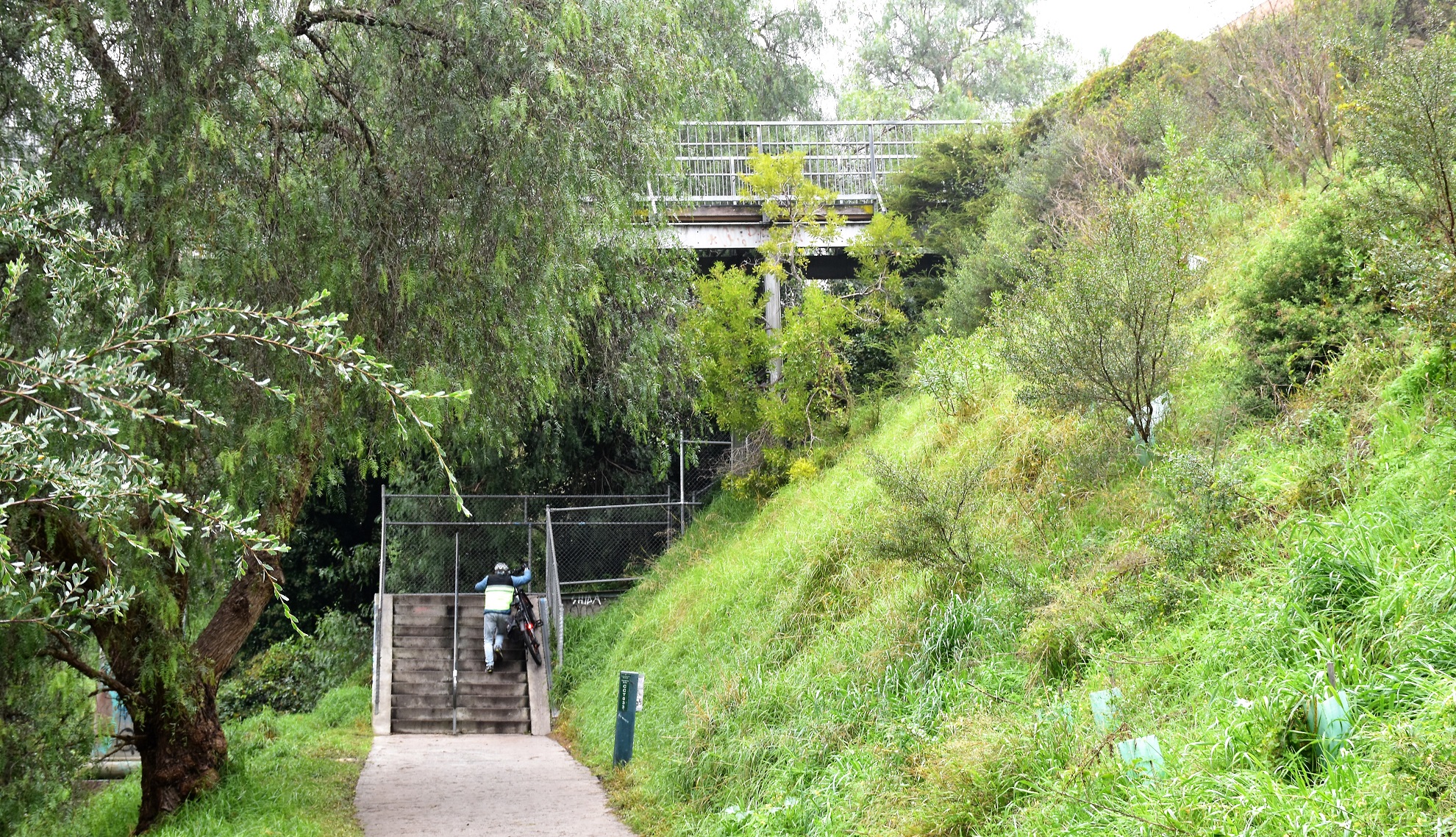
I'm thinking that pushing an electric assist bike up these stairs onto the Collins Bridge maybe the hardest this bloke has worked all day.
Once over the Collins Bridge I picked up a more informal path that stayed fairly close to the river again. On the opposite side of the river here is the Carlton & United Brewery, the top of its industrial smoke stack disappearing into the low fog. This section of my stroll was probably the best of the day I think, as after staying close to the water level for a while the benched track started to climb higher up the sides of what is more or less a gorge. After a fairly easy climb that featured many river views, and I'm thinking maybe city views if the fog wasn't down so low, I emerged from the bushland into an empty suburban park beside Wolmer Street.

Collins Footbridge.

After crossing over Collins Bridge I picked up the dirt path that runs close to the river.

The top of the stack at the CUB site across the river was hidden in the fog.

This section of the walk was arguably the best of the day.
My mornings walk was pretty well coming to its conclusion now. After climbing up through the park and then along Wolmer Street I carefully crossed the fairly busy Studley Park Road near a bus stop before picking up an un-signposted track descending back into the bush behind the bus stop. This track soon dropped me onto the Yarra Boulevard which I immediately crossed over and picked up another un-signed pad that dropped off the boulevard back into the scrub again. A couple of minutes down this rough pad had me back at the ute and heading off for home.

As the track started to climb I got some nice Yarra River views.

After one last climb...

... I emerged from the bush into this suburban park beside Wolmer Street.

I passed by the Villa Alba Museum as I climbed up Wolmer Street.
The Dirt.
According to my GPS I walked around 7 kilometres and climbed about 129 metres this morning. This is a nice urban walk, it is a little hard to believe sometimes that you are only a few kilometres as the crow fly's from the Melbourne CBD. While grey and overcast conditions arguably aren't the best for photos on this stroll keep in mind if you come here on a blue sky and sunny day you won't be alone, so if we are still social distancing then the cold foggy conditions maybe a good thing. Sections of this walk follow the sealed Main Yarra Trail which makes for easy walking, other sections follow some rougher un-sealed walking tracks which are a little tougher, although its all pretty easy really. There is a café at the start of the stroll and another one at the Collingwood Children's Farm about two thirds into it. I used an old set of notes and a mud map out of one of Tyrone Tomas' old books 40 Bushland & Park Walks in Metropolitan Melbourne and even with the book dating back to 2001 it was still accurate. Before leaving home I had a. good look at Google Maps and I also used my GPS topos on the stroll.
Relevant Posts.

After crossing Studley Park Road I picked up this un-signed track dropping into the bush behind a bus stop.

Crossing over the Yarra Boulevard I dropped down another un-signed track.

Time to head home.


No comments:
Post a Comment