 |
| Olinda Creek tumbling down over the lower falls. |
Looking at the weather forecast this past week had me considering speeding up the construction of my ark. I’ve got one in the planning stages due to climate change, and the fact that my house is all of about 10 cm above sea level, yep after Tuvalu goes under, chateau Feral will be the next to go. Where was I?….oh yeah, the forecast. The BOM had rain of almost biblical proportions forecast for Melbourne a few days out with 40 mm forecast one day and 80 mm the next. Not wanting to waste a disaster I decided to head back up to check out Olinda Falls, figuring that all the precipitation should do a little to help my photos of the tiny waterfall. Of course almost as soon as I committed to this plan the rain seemed to disappear into the ether, bugger. Having made the plans now I was a committed to the walk though, with around 30 mm of rain having actually fallen in the last couple of days I was hoping that the falls might have a bit of water coming down them.
 |
| It was another fairy early start this morning, I was on my way before 8am. |
The good news is that the Dandenong Ranges are only a relatively short drive from home so I was pulling on my boots and setting off before 8am this morning. This stroll starts beside the Mt Dandenong Tourist Road and immediately drops into a gully following a tributary of Olinda Creek downstream. This section of the walk can be pretty slippery and muddy in winter sometimes, but even after the rain of the last few days it wasn’t too bad this morning. It’s a very narrow section of the Dandenong Ranges National Park here, basically the creek gully is the park, with rambling house’s crowding each side. Normally the private property is almost invisible as the track stays near the creek but, after all the recent storms that had gone through that meant that today I had the surrounding gardens autumn leafs blanketing the ground. Now while the leafs definitely aren’t native they did add a bit of colour to the damp bush, with all the weeds encroaching the gully from the surrounding properties we are not talking pristine wilderness here though.
 |
| There are quite a lot of deciduous trees on nearby private land. |
The track down here is called Mechanics Track and apart from the creek and it’s damp environments it also features some very impressive Mountain Ash trees, as I’ve waffled about these trees before on my blog but these huge trees are a bit of a favourite of mine. The vegetation can sometimes crowd the pad a little going down here but it was all pretty clear and easy this morning, only the short section after crossing Falls Road before the Olinda Falls side trip giving me a bit of a drenching as I pushed through the scrub.
 |
The walk down Mechanics Track features a lot of ferns and Mountain Ash.
|
Dropping down to to the Upper Olinda Creek Falls I found the creek flowing fairly well this morning. The upper falls are more of a cascade really, it’s a little hard to get good photo’s from the constructed lookout above the creek. Normally that wouldn’t have provided too much of a conundrum to me as I would of scrambled down into the creek, but I was thinking that the muddy bank probably didn’t need walkers slipping and sliding down it as this is a pretty high use area not wanting to cause any more environmental degradation I stayed on the lookout (judging by the many eroded pads it looks like many don’t). I’m thinking that the best opportunity to get a good photo at the upper falls is probably to zero in on one part of the cascades and concentrate on that so, using the safety rail as a tripod that’s what I did.
 |
Upper Olinda Falls
 |
 |
| The cascading Olinda Creek at Upper Olinda Falls. |
|
|
Leaving the upper falls I dropped down the steeper track to Lower Olinda Falls, it’s a bit steeper and there are lots of stone steps but it’s worth the effort I reckon. Arriving above these more substantial falls I hoped around the slippery rocks for awhile taking in all the scene. With the low morning sun slowly lighting up the valley Lower Olinda Falls looked pretty sweet this morning. The lookout here is on the far side of the creek and it gives a good view up stream to another small waterfall as Olinda Creek drops steeply into the valley, via a series of small waterfalls and cascades. Once again, utilising any available firm surface to use as a tripod I tried to get a reasonable photo, the contrasting light conditions making it interesting.
 |
The Lower Olinda Falls are a little more substantial although the light and shade was making things tricky.
 |
Looking down the valley of Olinda Creek into the early morning sun from the lower set of falls.
 |
 |
| It's a relatively steep descent and climb into and out of the lower falls. |
|
|
|
Instead of retracing my route back to the ute I now dropped down Cascade Track to eventually come out of the bush onto the substantial Barbers Road. The highlight of this short section of today’s walk was probably the view down and across the valley with the early morning sun slowly starting to burn off the overnight mist, with shafts of sunlight penetrating through the mist and lighting up the trees in the valley in an almost translucent light. Once on Barbers Road I wandered down to meet VW Track near a small weir on Olinda Creek.
 |
Cascade Track
 |
The weak sun was slowly burning off the overnight mist.
 |
 |
Mountain Ash
 |
| I've just emerged from the scrub at the bottom of Cascade Track onto Barbers Road. |
|
|
|
|
Mr Chapman suggested that the start of VW Track might be a little indistinct but VW Track was like the Hume Highway on this visit, the wide gravel surfaced track climbing fairly steeply up a spur. The forest in this section of the park is a lot drier than it had been as I’d descended down beside Olinda Creek, so I was able to get a few glimpses through the more sparse vegetation. With the track levelling out a bit I arrived at an area that had recently had a controlled burn through it, now the wide gravelled track made sense. Passing along beside the burnt area the contrast between the lush green unburnt side of the track and the toasted blackened side was fairly extreme.
 |
This little weir on Olinda Creek is at about the spot that VW Track leaves Barbers Road.
 |
The forest on the spur was a lot drier than that which was down near the creek.
 |
OK?
 |
| There had been a prescribed burn along VW Track. |
|
|
|
After five minutes or so I’d passed by the burnt area and headed along Bartlett Track to meet up with Falls Road. Arriving at Falls Road there were all sorts of warnings posted on the gate saying access to the area was closed due to the Parks people conducting a prescribed burn, hmm. Not to worry I suppose, they weren’t likely to be burning here for a few days after the last couple of days rain I don’t think. It was now mid morning and turning onto Falls Road I met my first walkers for the day who were ambling along in the other direction walking their dog.
 |
I followed Bartlett Track back to Falls Road.
 |
| Oh |
|
The circuit part of this walk came to an end as I crossed Olinda Creek on Falls Road and turned back up Mechanics Track. Once again now I was passing beneath huge Mountain Ash trees and ducking under huge Man Ferns as I climbed towards Mt Dandenong Tourist Road. After mucking around a bit taking photos of all the colourful autumn leafs I eventually emerged from the quiet solitude of the gully onto the side of the busy tourist road, my week’s peaceful interlude was over again.
 |
Climbing Mechanics Track, once again I was back in the Mountain Ash.
|
The Dirt.
I took my GPS on this walk but forgot to reset it after the walk so I’ll go with Mr Chapman’s stats which say that I covered 7.2 kilometres and climbed 370 metres on this medium grade stroll. I’m calling it a medium grade only really because there is a fair climb involved from the bottom of VW Track back up to the car park at Mechanics Reserve. I’ve been to Olinda Falls quite a few times over the years and I’m thinking that these falls are definitely best seen after some good rains. Search around the inter web a bit and you’ll find some reasonably photos of the falls floating about, Mr Fiasco has got some good stuff online off the top of my head. The section of this walk down Mechanics Track and to a lesser degree, Cascade Track can get fairly muddy in wet weather. Like I mentioned above I used the notes published by the House of Chapman out of their
Day Walks Melbourne book, it’s walk number 26 in the second edition of that book.
Relevant Posts.
Dandenong Ranges Walk, Dandenong Ranges National Park, 2015.
Ferny Creek, Dandenong Ranges National Park, 2017.
 |
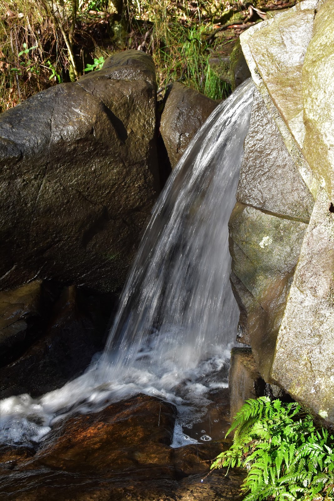
| It looks like at some stage water was pumped out of this tiny creek - for irrigation I'm guessing? |
 |
| Climbing back up Mechanics Track to the ute. |


No comments:
Post a Comment