 |
| Mount Worth State Park |
This is a walk from the
House of Chapman that was written up in the 2001 edition of Day Walks Victoria. In later editions of the book Mr Chapman has modified the walk so as not to include the five kilometres along the extreme western end of the stroll which included a meander along the Grand Ridge Road. I’ve always wondered why he dropped this walk as every man and his guide book writing dog seems to have written up the shorter stroll at Mt Worth, the one that drops off Moonlight Divide down Moonlight Link Track to Moonlight Creek. So after an extensive three minutes of research on Google and not finding any obvious issues I decided to head down and check things out.
 |
| The Moonlight Creek Picnic Area was deserted when I set off this morning. |
Thankfully our summer weather cooperated a little and it wasn’t stinking hot today, although by the time I’d finished the temperature was still hovering around 30˚, which is hot enough. One thing that became immediately obvious as soon as I set off though was how dry the bush was, I’ve been down here many times over the years but I can never remember seeing it this dry. Leaving the ute I set off on the reasonably short loop walk to Gardiners No.2 Mill first, the old tramway making for an easy warm up to my days endeavours.
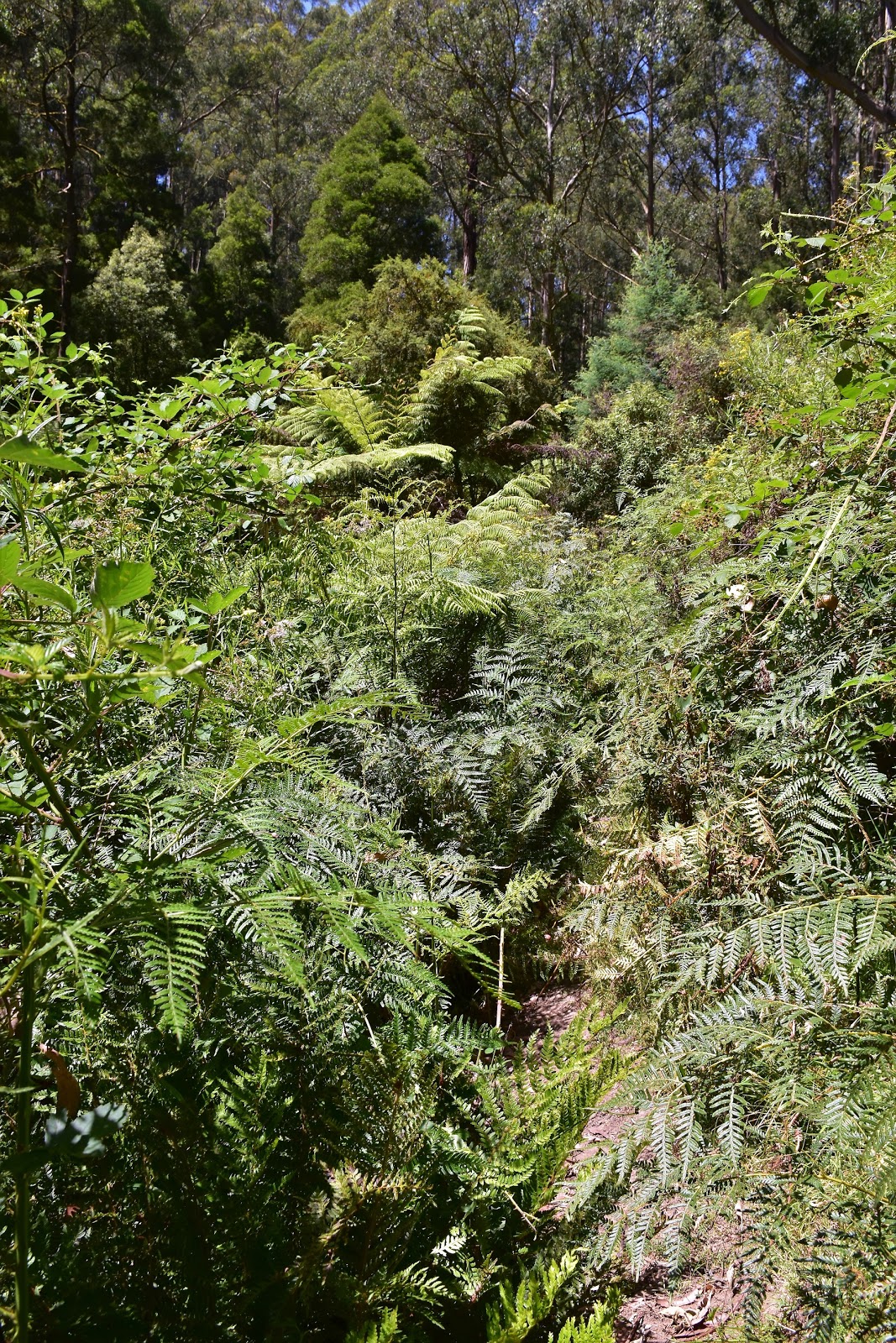
 |
There is plenty of this kind of scenery at Mt Worth State Park.
 |
| I was walking an old tramway above Clark Creek as I headed to Gardiners No2 Mill Site. |
|
I was at Gardiners No.2 Mill Site last year on my Waterfall Bower Walk but I’d come in from the opposite direction so today I was completing the loop…so to speak. I’m thinking if you are ever going to go over a walk again then Mt Worth is as good as anywhere as the scenery here is pretty special. After making a fairly cursory attempt to get a photo of some rusting machinery at Gardiners No.2 Mill Site I continued on towards Trevorrows Mill Site. This section of track drops down to cross Clark Creek before sidling it for awhile and then crossing over a ridge and dropping down to Larkin Creek and is generally always muddy, not today though as I was able to stride out with a bit of confidence.
 |
There are a couple of relics rusting away in the forest at Gardiners No.2 Mill Site.
 |
Gardiners No.2 Mill Site
 |
The section of the walk between Gardiners No.2 and Trevorrows Mill Sites is normally pretty muddy, not on this visit though.
 |
| Even the moss looked like it needed a bit of a drink. |
|
|
|
Like at Gardiners No.2 Mill Site there is only a few relics left rusting away in the bush at Trevorrows Mill Site, the short sidetrack is still worth taking though if only to check out the photos on the information sign of the old mill, it’s hard to imagine such a bustling site when you gaze int the scrub. Leaving Trevorrows Mill Site I took the loop around Giants Circuit to get back to the carpark. Giants Circuit is a very easy tourist loop that is perfect for first time visitors to Mt Worth State Park I think, the very easy and well graded track making it easy to concentrate on the beautiful, cool temperate rainforest all around.
 |
Trevorrows Mill Site
 |
| Giants Circuit is an easy walk on a good track. |
|
Arriving back at the car park at Moonlight Creek Picnic Ground my days walking was about to get a bit harder. By-passing the ute I continued on and picked up the start of Moonlight Divide Track and started climbing through magnificent Mountain Ash. For the first half a kilometre the Moonlight Divide Track is pretty easy but after passing the short link track down to Moonlight Creek on the right the grassy track hooked into a very steep little climb. Thankfully the Friends of Lyrebird Forest Walk have installed a nice bench seat three quarters of the way up the steepest pinch and indeed I made good use of it today. Leaving my comfortable seat eventually, I climbed the remainder of the steep section, cresting the rise to see a Lyrebird scratching around on the track ahead of me. Lyrebirds being a bit of a feature of Mt Worth State Park in my experience.
 |
Heading up Moonlight Divide Track through the beautiful Mountain Ash.
 |
Moonlight Divide Track
 |
I'll have to get out to Mirboo North and re-walk the Lyrebird Forest Walk soon.
 |
| There are plenty of Lyrebirds in the Mt Worth Forests, although they are not always easy to photograph. |
|
|
|
After the first really steep pinch Moonlight Divide Track continues on along a roller coaster ridge line, occasionally climbing a steep pinch but mostly providing very good walking. After passing the track down to the Waterfall Bowers off to the left and then shortly Moonlight Link Track down to my right I headed off on the section of the walk that has been omitted from all current guide books. Not too sure what to expect I was pleasantly surprised to find a clear and easy track to follow as I slowly made my way towards the southern boundary of the park. Passing an old dam, Chapman talks of cleared land along here, but everything is very well vegetated now and I soon arrived at the fence line marking the edge of the park.
 |
Once over the initial steep pinch the soft, grassy Moonlight Divide Track makes for very nice walking.
 |
I headed left here towards the park boundary.
 |
Moonlight Divide Track
 |
| Chapman mentions cleared country around this old dam but it's all revegetated now days. |
|
|
|
Climbing over the Mt Worth State Park boundary fence I followed an old dirt road to my right and soon emerged onto the bitumen Grand Ridge Road. When I’d done this walk years ago my ageing memory had me gazing across cleared land south towards Westernport Bay from the road so setting off along the road today I was interested to see what I’d find. Initially my road bash had me following the quiet road through native bush on both sides of the road, after passing a rough shelter and picnic table in the forest though I did start passing by a bit of farm land to my south, although even if I had good eyes I doubt this was the spot I could see Westernport Bay. Continuing on I arrived at the thriving metropolis of Seaview, I’m thinking that this was the spot that I can remember with the long range views but regrowth has now largely knocked out any real views. What Seaview lacked in views though it made up for with something more valuable to me now, a seat in the shade to have a bite to eat and drink, yep from what I could see the only community facilities in Seaview consisted of a bus stop…which just happened to be the perfect spot for a break.
 |
Climbing over the gate I left the Mt Worth State Park for awhile.
 |
This spot would be tricky if walking the circuit in the opposite direction, it was easy enough for me today though as I just came down the old road and veered right onto the Grand Ridge Road.
 |
This old hut on the Grand Ridge Road would provide a bit of shelter in inclement conditions.
 |
| The Grand Ridge Road is an under rated gem I think. |
|
|
|
The Grand Ridge Road is one of those gems that fly’s under the radar a little I think, I spent thirty minutes sitting beside the road today in Seaview and only saw a couple of cars and a couple of bikes go past me. Setting off again I was looking for McDonalds Track heading off to my right which I needed to follow a few hundred metres before heading off into the scrub again. Sure enough McDonalds Track materialised about when I thought it should and after checking out the extensive view down towards the Latrobe Valley I continued on a couple of minutes to pick up the old 4wd track that would drop me down to Moonlight Creek.
 |
The view from the Grand Ridge Road.
 |
By the time I reached the locality of Seaview the day was warming up a bit, the bus stop was a good spot to stop and have a bit of a break.
 |
The view down to the Latrobe Valley from McDonalds Track.
 |
| Leaving McDonalds Track I headed back into Mt Worth State Park along Moonlight Link Track...there is a signpost just on the other side of the pines. |
|
|
|
Once again I found myself on a distinct track that even had a signpost (a few metres over the boundary fence, which I had to climb). After a short grassy climb on a slashed track I started the fairly steep descent down to Moonlight Creek, with the ground bone dry at the moment this was all pretty straight forward but if conditions were a bit damper under foot then you’d want to be a bit careful going down here. Bottoming out at Moonlight Creek I was now in very familiar territory, all that was left to do now would be to follow the creek all the way back down to Moonlight Creek Picnic Area.
 |
Moonlight Link Track climbs for a few metres initially before....
 |
| ....dropping very steeply down to Moonlight Creek. |
|
Now while it was all pretty straight forward navigational wise it was also easily the roughest walking of the day. This track along Moonlight Creek has really deteriorated over the years. Years ago it was a clear track with some good walking infrastructure in the way of bridges, etc as the track made it’s way downstream through a ferny wonderland. Now days a lot of the infrastructure has fallen into disrepair and the track is very overgrown in sections, particularly where it crosses open areas in the forest, Blackberries are a real issue here. If Parks don’t spend a bit of money along here soon then this section of the walk will really only be for very experienced walkers looking for a bit of a challenge, which is a shame really as the track heads through really nice country.
 |
The end of the easy walking for awhile.....If you look carefully you can see Moonlight Creek Track heading off over a bridge in the centre of the photo.
 |
Moonlight Creek Track
 |
The small waterfall on Moonlight Creek...I suppose I'll call it Moonlight Falls.
 |
| Sections of Moonlight Creek Track are getting pretty over grown. |
|
|
|
The Moonlight Creek Track soon passes a nice little waterfall on Moonlight Creek which is worth the short detour to check it out, not only providing a nice shady nook but also providing me with an opportunity to wet down my hat today. Resuming my walk I continued on down Moonlight Creek, the rough pad crossing quite a few damp and ferny side gullies as it headed down stream. There are also a couple of historic old mill sites along here although both Bromfields and Seymours Mill Sites have virtually returned to nature, slight openings in the forest being about the only clues as to the history of those spots.
 |
Moonlight Creek Track
 |
I had to crawl under this one.
 |
Moonlight Creek Track climbs in and out of quite a few side gullies.
 |
| Not only is this section of the walk getting pretty overgrown but the infrastructure is pretty run down as well. |
|
|
|
With the ground being pretty dry on this visit I still made pretty good time on the rough rack and it wasn’t too long before I arrived at the short link track up to the Moonlight Divide Track. Moonlight Creek Track from here back to the car park is once again a very easy track, even being paved in a couple of spots. Passing Maslins Mill Site Moonlight Creek Track crossed to the north side of Moonlight Creek for a hundred metres or so before crossing back over and heading back to the Moonlight Creek Picnic Area and my ute. Arriving at the car park on this, the Australia Day Long Weekend, I was mildly surprised to see only one other vehicle in the car park.
 |
If the Moonlight Creek Track is continued to be neglected then experienced walker will be the only ones using this route in a couple of years.
 |
| The last kilometre of Moonlight Creek Track makes for very easy walking again. |
|
The Dirt.
I walked around around 18 kilometres and climbed 530 metres on this Medium-Hard grade stroll. To be honest I’m not sure why the western end of this walk has been left off current guides, the tracks were all clear and mostly well signposted (going around in the direction that I went). The three kilometres or so along Grand Ridge Road sounds a little crappy but in reality there is almost no traffic on this road, I saw only maybe 10 or 12 vehicles. The section of the walk that is a little rough is the Moonlight Creek section, Parks Vic have a couple of warning signs up along here warning of the rough conditions and suggesting only experienced walkers tackle it, so maybe it’s a plan to let it go a bit? Like I mentioned earlier this walk was written up by Mr & Mrs Chapman and Mr Siseman in the book 2001 edition of Day Walks Victoria, it’s walk number 40 in the book although I took a few liberties and walked the shorter easier Gardiners No.2 Mill Site first up. I’ve mentioned it before but I think Mt Worth State Park is a gem of a park, the towering Mountain Ash and fern filled gullies along with generally great walking tracks make this a good spot to visit.
Relevant Posts.
The Waterfall Bower, Mount Worth State Park, 2018.
Moonlight Circuit, Mount Worth State Park, 2016.
Mount Tassie Loop, Grand Strzelecki Track, Tarra-Bulga National Park, 2017.
 |
| Arriving back at Moonlight Creek Picnic Area there was still only one other vehicle in the car park. |


One of my favourite areas to hike around Melbourne. Interesting version of it though. I hope Parks Vic do not abandon this area though...it would be a real shame. Thanks for posting this though.
ReplyDeleteCheers Dougal, thanks for checking the post out. You're right it is a magic spot and it's a shame it's appears to be getting a bit tired in a few spots.
ReplyDeleteWhere you climbed over the Gate on Mc Donald’s track was my Grand parents first dairy farm, prior to becoming a state park.
ReplyDelete