 |
Fossil Beach Geological Reserve.
 |
| Fossil Beach Geological Reserve. |
|
I was looking for a walk close to home today again as I’d spent the morning watching showers scud through while I sat in front of the telly on the couch. Now that may sound all pretty depressing but after our long dry sumer it was quite uplifting watching the misty rain fall on the the bone dry wetlands behind my house. So when the sun came out this afternoon I was in a pretty good mood as I set off on this fairly easy stroll.
 |
| Looking south down Port Phillip Bay from todays start point. |
I was lucky enough to get Sam to drop me off in Mt Martha today so all I had to do now was head north-north east along the coast and I’d eventually arrive back at Mornington and my ute. While I’ve lived in this area all my life and I’ve walked sections of this coastline I’d never actually walked the whole distance before, so this afternoon was going to be a little exploratory. My basic aim today was to stay as close to the water as possible. So after mucking around with my recalcitrant GPS for half an hour trying to get it to acquire and then lock onto satellites, I eventually shouldered my pack and set off from the Mt Martha Yacht Club.
 |
| I was heading north towards Mornington. |
Low tide was predicted for the middle of the day today so setting off just after 2pm I figured that the beach sections would be all sweetness and light as I frolicked along the hard sand, I was wrong! Walking down to water level I quickly realised that the big north westerly wind must be pushing the water higher onto the beach as I was straight away walking through very soft sand, and to top it off I was more or less walking into the wind too, oh and the afternoon was hot, low 30˚ hot. So trudging my way along the beach passing the colourful beach houses and sunbathers I was now in for a long afternoon.
 |
| I was only a couple of hours after low tide but I'm thinking that the strong north westerly wind was pushing the water a bit higher than normal. |
After walking Mt Martha Beach, crossing over the closed mouth of Balcombe Estuary and then walking the length of Hawker Beach I finally left the soft grainy sand for awhile. Following an old breakwater I passed a few more beach houses before dropping down onto the rocks at water level, the walk now got a whole lot better. I now alternated between easy scrambling around headlands and beach combing my way along numerous small beaches, most of them deserted. There isn’t a lot of access down to this section of the coastline so even though the tops of the cliffs are lined with flash houses and has the major Esplanade running along them, not many punters seem to make it down to sea level, so things can feel a lot more remote than it actually is.
 |
I walked this old breakwater at the end of Hawker Beach for a few hundred metres, which made for easy walking for awhile.
 |
Hawker Beach
 |
Looking back towards Mt Martha I dropped down onto the rocks at the end of the breakwater at Hawker Beach, the easy walking was over for awhile now.
 |
| The walking now got a lot more enjoyable. |
|
|
|
The cliffs are a real highlight of this walk I think, they consist of soft multi coloured clays and are quite pretty, especially when the sun came out. It was a bit hit or miss when it came to the sun though, there were lots of dark clouds building up over Port Phillip Bay so more often than not I was walking under overcast skies, every time the sun came out I’d scrambled to take a couple of photos before I’d lose the sun again. Continuing along I passed through the intriguingly named Fossil Beach Geological Reserve. I imagine this reserve has something to do with the colourful cliffs that I was passing by, or the fact that our indigenous people lived here for thousands of years before European settlement, or maybe both.
 |
Between headlands I walked a series of beaches, some covered in these rounded rocks and some with sand.
 |
As there is no easy access to a lot of this section of the coastline it can feel surprisingly remote.
 |
Conditions were now warm and unsettled.
 |
The cliffs along here consist of very soft clays.
 |
Scrambling around the headlands required some caution.
 |
Approaching Fossil Beach.
 |
There looked to be some more weather heading my way across Port Phillip Bay.
 |
Looking back towards Mt Martha, progress was still being made...
 |
The scenery was pretty sweet.
 |
Fossil Beach.
 |
Fossil Beach.
 |
| Fossil Beach Geological Reserve....sorry about this post tuning into a bit of a photo dump! |
|
|
|
|
|
|
|
|
|
|
|
Scrambling around some more headlands I arrived at another very old breakwater, these sections of breakwater made for a bit of welcome relief after all the rock hoping I’d been doing. Leaving the breakwater though I once again resumed the adventurous coastal walking as I headed to what was the nicest beach of the day Coral Cove. Coral Cove wouldn’t look out of place on a tropical island I didn’t think and the small beach was almost deserted today, if I’d had a little more time up my sleeve I would of definitely stopped for a swim here. As it was though the walking was taking a bit longer than I’d envisaged so I decided to keep trudging along on my way to Mornington, climbing now up onto the cliff top path that runs beside the Esplanade.
 |
There is a fair spring flowing out from the cliffs in one spot.
 |
Fossil Beach Geological Reserve
 |
I found myself another section of breakwater to follow for a few minutes.
 |
Rock hopping my way around to Coral Cove.
 |
Fossil Beach Geological Reserve.
 |
How easy is this?... another section of breakwater.
 |
Even the rocks lining the breakwater looked colourful.
 |
More rock hopping, approaching Coral Cove.
 |
 |
The beautiful little Coral Cove.
 |
| Coral Cove |
|
|
|
|
|
|
|
|
|
|
Almost as soon as I started walking through the low coastal heathland along the cliff tops the wind swung over from a strong and hot north westerly to a cold and even stronger south westerly, the temperature dropping by around 10˚ in a couple of minutes. My route now followed a winding path that burrowed through the scrub, sometimes I’d breakout onto a lookout above the cliffs and at other times I’d be walking beside the Esplanade. All in all though, the cliff top walking along here is pretty nice, especially so now that it wasn’t baking hot. After a short section right beside the Esplanade I took the short side trip out onto Linley Point to check out the view, and with about 5 different lookouts spread around the cliffs on the point, there was no shortage of vantage points to take in the scene.
 |
Looking back along the coastline over Coral Cove, all the way down to Mt Martha in the distance.
 |
The cliff top pad was pretty easy walking.
 |
| Looking south towards Dava from Linley Point. |
|
|
Looking up towards Mornington I could see that my beach combing wasn’t over for the day, Fishermans Beach was spread out below me. Dropping back down to water level I once again found myself slogging my way along very soft sand, the few hardy remaining sun bathers looking quizzically at me as a shuffled my way past the beach houses in my walking gear. The trick along here is to pick the right spot to once again climb back onto the cliff tops, the northern end of Fisheries Beach looks like it has no easy cliff top access. I headed up the track just beside a beach house that was selling fish and chips. Not only did this track get me back onto the cliff top but even more of a bonus was that it had a tap that allowed me to wash the grainy sand off my feet, there is nothing guaranteed to ruin my day more than coarse sand rubbing under the straps on my sandals.
 |
I dropped back down to the sand again at Fishermans Beach.
 |
The wind had swung around to a south westerly now and the temperature had dropped around 10˚.
 |
| There is no easy access to the cliff tops from the northern end of Fisheries Beach. |
|
|
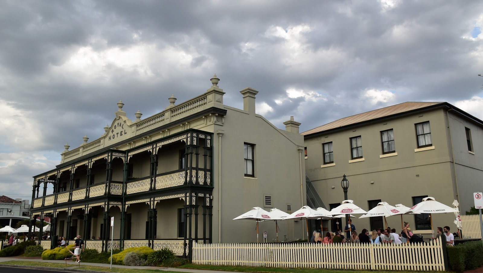
Back on the cliff top again the easy walking resumed as I made my way the last kilometre or so to Snapper Point. The go along here is to take the informal path through the scrub that keeps close to the cliff edge, while it’s a bit vague and has a bit of overhanging scrub it’s better than walking along beside the Esplanade. After passing between the cliff tops and the Mornington Bowling Club I eventually popped out of my tunnel of Tea Tree opposite the Royal Hotel, I was now back in very familiar territory, but that’s a whole different story!
 |
Way out in the bay the Spirit of Tasmania was steaming it's way up to Melbourne.
 |
I was now following a less formal track between the cliff tops and the Esplanade.
 |
| The Royal Hotel...these walls could tell some stories! |
|
|
Reluctantly bypassing the Royal (and Kirk's next door) I trudged the last few metres to Snapper Point, passing above the small Royal Beach on the way. Entering the grounds of the extensive parklands on Snapper Point the parched lawns were looking very the worse for wear at the tail end of our long dry spell. This park would be a nice spot for a picnic if anyone wants to bring their ankle biters down I think. Passing through the children's adventure playground I crossed over Snapper Point Drive and arrived at the Mornington Shipwreck Memorial and turned off the GPS, my afternoons mild adventure was over. Meandering my way up Main Street back to my ute, passing by the well coiffed crowds that were flocking into town ofter the Mornington Races I felt even more out of place than I had on the beach, it looked like it was going to be a big night in town tonight!
 |
Royal Beach
 |
Snapper Point Park.
 |
| Passing through Snapper Park it was easy to see that we had been through a long hot summer. |
|
|
The Dirt.
I walked 7.7 kilometres and climbed 103 metres on this afternoons easy-medium grade walk. Now wile the distance and the climbing involved would suggest that this walk is dead easy there are a couple of issues to consider. The first one being that the sand is particularly soft and grainy, I started my walk a couple of hours after dead low tide and it was a tough slog at water level on the soft sand. The other issue is that when I left the sand the walking can get a little rough, there is even a bit of scrambling around a couple of small headlands - where not talking the Western Arthurs here, but you’ll still need your hands in a couple of spots. As far as I know there are no published notes for this stroll but it’s not a hard walk when it comes to navigation, I basically headed to the beach at Mt Martha and turned right. I suppose the only trick is to decide when to leave the beach and climb to the cliff tops. I was lucky enough to have Sam drop my off at the start of the stroll but if you only have one car then there is a bus that runs along the coast between Mornington and Mt Martha, so public transport is a viable option.
Relevant Posts.
Mornington to Frankston Coast Walk, 2014.
Balcombe Estuary Nature Park Trail, 2014.
Mt Martha, 2016.
 |
| The Mornington Shipwreck Memorial was as good a place as any to end my afternoons stroll. |


A nice bit of photo journaism. Dont aologise for the photo dump, they maketh the story. aaim often at fossil beach flying my droe or taking photos of the sunsets. I was at Birdrock Beach a couple of days ago and was concerned by two things; 1. the number of dead sebirds [4] and 2. the amount of plastic washed up on the shore. Is there a connection?
ReplyDeleteI hope that their is no connection however I fear that man is slowly choking the earth to death! Fossil Beach is a nice spot, I'm thinking sunset might be a good time to revisit one day....just as the setting sun lights up the colourful cliffs.
ReplyDeleteGreat post! I really appreciate your honest and thoughtful reflections here. If you’re into exploring personal growth and real-life challenges from a fresh perspective, you might enjoy checking out my site as well—[YourWebsiteName]. It’s a space where I share insights and stories on resilience and daily motivation. Keep up the inspiring work, and thanks for sharing such genuine content!Peterniven
ReplyDelete