
I was enjoying the shade this afternoon as I shuffled along Main Road towards White Elephant Gap.
I've looked at this walk a few times over the years, the name White Elephant Gap intriguing me somewhat. White Elephant Gap is a pass on the Great Dividing Range that was surveyed back in the day however with lower and easier passes being discovered over the mountains then this pass was never used - hence the White Elephant bit. Anyway, with half a day up my sleeve I decided that the time was right to make the trip up to Wandong Regional Park and check things out.
Andersons Garden Camping Area
This walk was last written up by Mr Thomas back in July 2006 however as is pretty common now days since Mr Thomas' visit the area has been decimated by big bushfires. The Black Saturday bushfires that obliterated this park were back in 2009 so I figured that things might be starting to recover. Parking the ute at the almost empty Andersons Garden Camping Area I could see straight away that while the bush was recovering the country was still suffering a fair bit. My route this afternoon had me shuffling my way back out the camp access road before I swung left up Clonbinane Road for a couple of minutes before swinging right onto Raynors Road and then again swing right onto what I think might be The Ladder Track. Whatever the name of this track is it starts off pretty shitty, the track climbs up the valley of Drag Hill Creek and is very eroded and messed up by 4wd's and trail bikes, I spent my first 15 minutes along here skirting my way around huge water filled trenches gouged out by the 4wd's. Once over the creek I went right up an un-signposted fork and the track started to climb out of the valley and while the walking was never super scenic for the next thirty minutes at least I wasn't skirting around huge bog holes.
Making my way back out of the camp I climbed Clonbinane Road for a couple of minutes before branching off right here... along the lessor Raynors Road.
After following Raynors Road for a few minutes I branched off right along this eroded track that climbed the valley of Drag Hill Creek... this maybe called The Ladder Track?
Once I'd crossed Drag Hill Creek the track started climbing and the walking got more enjoyable.
The bush up here is still struggling to recover from the Black Saturday Fires back in 2009.
Maybe this is The Ladder?
With the track that I was climbing now high above Drag Hill Creek the climbing eased off a bit and the walking became pretty easy. I was now trying to make my way out to Sheils Road and after avoiding a track off to the left and passing by a fire dam I did indeed emerge onto Sheils Road (although it was sign posted as Ryans Rise Road). Turning south (left) I followed this quiet gravel road for ten minutes to arrive at yet another quite gravel road, Main Road or maybe it was Main Mountain Road (yes, it's that kind of walk really), the names on my maps, notes, GPS and the various signposts rarely matched up on this stroll. Whatever the name of this gravel road actually is, it was the road that would lead me through White Elephant Gap. Heading east I rounded a corner and suddenly White Elephant Gap was in front of me, although to be honest if you weren't a geography nerd like me you'd be hard pressed to pick it. White Elephant Gap is just a low point on the gravel road, there is no sign posting or information to designate this historical spot so I'm thinking most people would just pass on through without realising the historical significance of this spot.
I passed to the right of this fire dam - it's a handy navigational aid.
Meeting this quiet gravel road I swung left... my maps and notes have it down as Sheils Road?
Arriving at Main Road (Main Mountain Road?) I headed east for around 600 metres to White Elephant Gap.
White Elephant Gap.
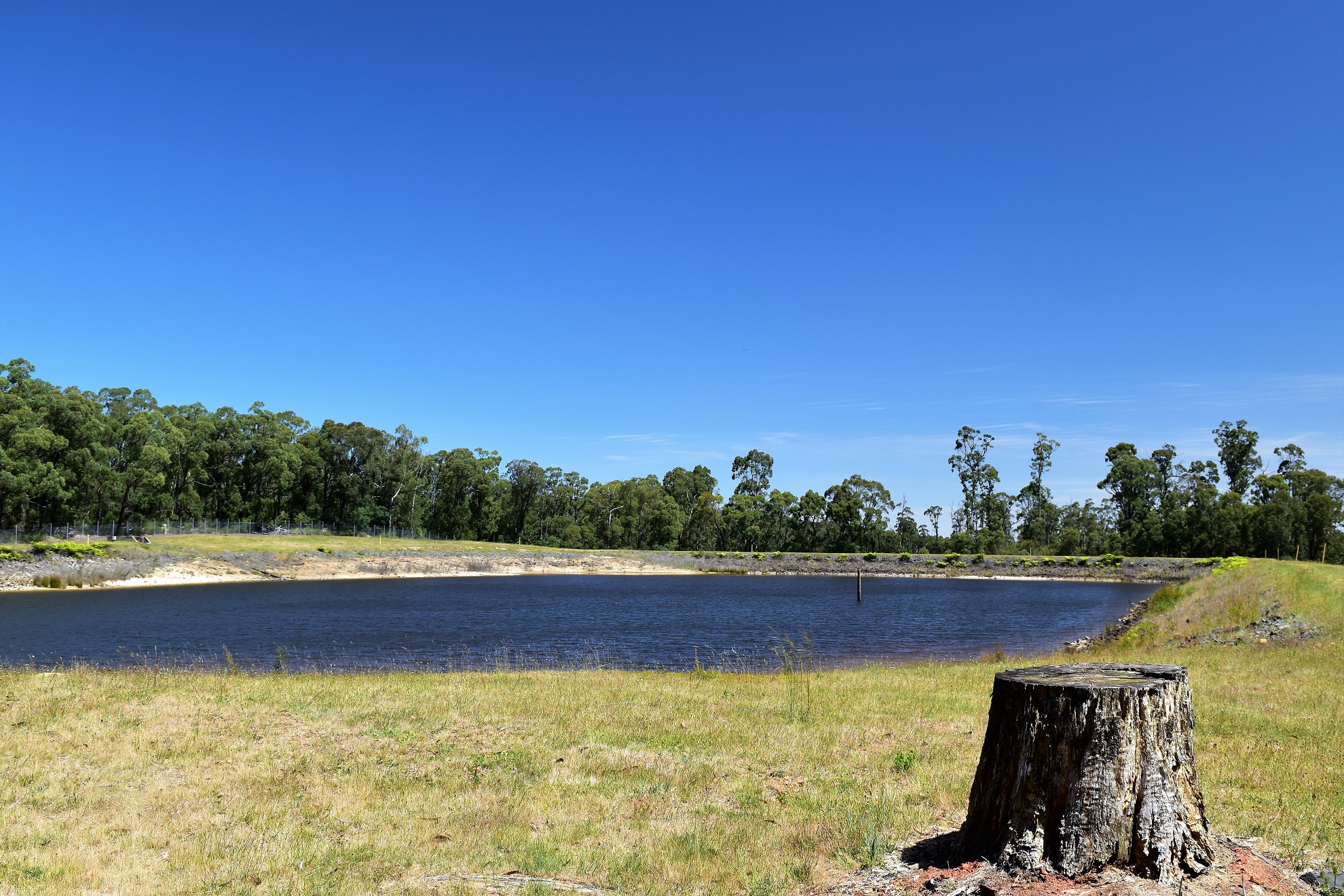
After passing through White Elephant Gap I shuffled off through the afternoon heat towards my next objective, the Hollowback Resevior. Now Mr Thomas suggests that the reservoir would make a pleasant spot for lunch however with the ambient temperature in the mid 30˚ range I was more interested in the possibility of a swim. Turning north along Raynors Road almost immediately I could see the Haollowback Reservoir in the bush off to my left, I could also see that it had a bloody big fence around it, hmm. Not being easily deterred I shuffled down Rayner Road to pick up the access track that Mr Thomas described in his notes and mud map hoping that maybe there was an opening in the fenced down this end of the dam, yeah...nah. Judging by the concrete tank traps stopping vehicles using the access track and the fence protecting the dam it looks like Hollowback Reservoir has now been Bogan Proofed... there'd be no lounging on the grass or going for a cooling dip this afternoon.

To access the Hollowback Reservoir I climbed this old 4wd track past the concrete tank traps.
The small Hollowback Reservoir... looks nice hey?
Unfortunately there is a cyclone fence around the reservoir now days.
With a swim out of the equation I shuffled off once again into the afternoon heat. I was now starting to make my way back down to Andersons Garden Camping Area, initially along Raynors Road before branching off and following Pipeline Track. The good news as I dropped down Pipeline Track was that due to it's steepness I was able to get some views north over the Mt Disappointment State Forest and even across to the conical looking Mr Piper over near Broadford. The bad news on Pipeline Track was that even though it was closed off to vehicles it was obvious that my bogan brothers and sisters had been coming through on their trail bikes... looking at the amount of chainsaw work they must of done to access this track you have to admire their determination I guess. Pipeline Track bottomed out as I crossed the gently trickling Greenshield Creek before I climbed up and and met Clonbinane Road opposite a water pumping station.
The dryer country up here was recovering a little better from the fires I thought.
Raynors Road drops back into the valley here on the left - I went right down the closed Pipeline Track.
The descent down Pipeline Track was steep and loose - I did get some distant views north towards the mountains in Mt Disappointment State Forest.
More views from Pipeline Track.
Pipeline Track bottomed out when I crossed Greenshield Creek.
Turning left down Clonbiname Road I should of just kept shuffling down it in hind site. Instead I followed Mr Thomas' notes and picked up an old 4wd track that pretty well paralleled the road 50 metres or so east. This little track didn't have a lot to recommend it really as it got more and more overgrown, before disappearing completely just as I re-joined Clonbinane Road again...yes, you can tell it was an average track as my bogan mates hadn't even bothered to push through this one in their 4wd's and trail bikes! Once back on Clonbinane Road I meandered my way down hill into the low afternoon sun until I arrived back at Raynor Road and my circuit was complete. With my loop finished I shuffled the last few metres back into the now busier Andersons Garden Camping Area, crossing Sunday Creek on the way. Being the Friday before a long weekend down here in Hookturnistan the camping area was now starting to fill up with punters although there was still plenty of free picnic tables for me to enjoy a break before I headed off on my next adventure.
I emerged from the bush onto Clonbinane Road near this pumping station....
... and took this rather pointless detour...
... before the 4wd track disappeared completely and I re-joined Clonbinane Road again.
The Dirt.
According to my GPS I walked around 9.9 kilometres and climbed 283 metres on what I'd call a medium grade stroll. This walk was a bit of a let down really, the country is still struggling to recover from the fires more than ten years ago and a lot of the tracks have been badly cut up by 4wd's and trail bikes - even the tracks that are meant to be closed off. Navigation on this walk needs a little concentration too, there are a lot of tracks both formal and informal that aren't mapped and there are also mapped tracks that have been totally reclaimed by nature, very few off them are signposted and when they are signposted they rarely matched up with my maps. Having said that, there are enough tracks around that so long as you keep an eye on your position on the map then there always tends to be a track heading off in the direction that you need to go. The walking along these tracks and quiet roads can be a little hit or miss too, there is a lot of unsightly mud holes and erosion trenches which can make some of the walking tedious although there is also some pleasant sections to go with it. I'm thinking that a weekday visit up here should have a lower bogan count. Unfortunately the historically significant White Elephant Gap isn't signposted and is just an anonymous low point in the scrub along Main Road (or Main Mountain Road?).
Relevant Posts.
Back on Clonbinane Road I followed it back down to Andersons Garden Camping Area.
Arriving back at Andersons Garden Camping Area I found it a little busier... although you'd hardly call it crowded.


nice
ReplyDelete