
Sanatorium Lake, Macedon Regional Park.

I re-set the GPS and set off along Anzac Road.
Grabbing my gear I shuffled across the tourist road and re-set the GPS at the intersection of the Mt Macedon Road and Anzac Road. The start (and end) of this walk is a bit of a road bash however if you have to walk a road then Anzac Road is a fairly good one I think. Initially the walk along Anzac Road was a bit undulating as I shuffled my way out of town past the big country estates with their extensive gardens, however after crossing Willimigongon Creek Anzac Road had me climbing a little more solidly into some native bush. After rounding a hairpin bend Anzac Road swings north and I now climbed up the side of steep valley with Willimigongon Creek occasionally in sight down to my left. Passing by my return route (a staircase descending on my right) I continued climbing past a few more estates, however mostly passing through native bush. Arriving at the small Willimigongon Reservoir, Anzac Road finished and I picked up a rougher 4wd track that continued on up the side of the valley until I spied the more substantial Orde Hill Reservoir through the trees where I veered right and climbed solidly up another old 4wd track until I reached the first switchback.

As far as road walking goes Anzac Road is about as good as it gets I think.

There has been some ferocious storms in Victoria this year, Willimigongon Creek is flowing beneath the tangled trees.

Anzac Road.

Anzac Road finished beside the small Willimigongon Reservoir...

... and I climbed 4wd tracks for awhile.
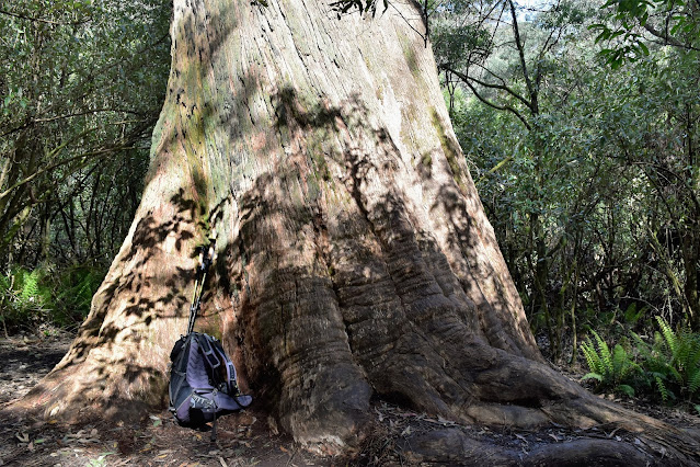
It was fairly important to identify this switchback as the next section of my stroll had a very faint, and sometimes non existent track to follow. My ongoing route was now up a very old and unmaintained walking track that continued to climb up the side of the valley of what was now the headwaters of Willimigongon Creek. Now it's been a long time since I've walked here although thankfully I spotted a very old track marker on a fallen tree which helped me identify the start of the old track, once on the track it was a matter of looking for clues in the form of cut trees or old benching to keep me heading in the right direction. Eventually the track that I'd been following passed through a slightly damper area where the ferns and bracken had completely revegetated the old track, so I set off to make my own way up to Barringo Road. As far as off piste walking goes this was pretty good, the bush was open enough that I could fairly easily get around any thicker sections of flora and while the climb was solid enough it was never ridiculous, and with Barringo Road running at right angles to me higher up the hill I was never going to get lost.

This is the spot where I left the 4wd track and picked up a very old and sometimes non existent walking track.

Initially the old track was reasonably easy to follow.

The further I climbed the less distinct the track became...

... before the walking track disappeared altogether and I was off piste.

The adventurous walking finished when I emerged from the scrub onto Barringo Road.
After around half an hour of mostly off piste climbing I emerged from the scrub onto the quiet Barringo Road and set off towards my next objective for the afternoon, Sanatorium Lake. Initially I followed the contouring gravel road beneath some towering Mountain Ash trees, before swinging left (north-east) up the Sanatorium Lake Picnic Ground access road. Once I'd passed through the picnic area I picked up the signposted nature walk as I headed left, now following the Sanatorium Nature Walk around to Sanatorium Lake through some very nice sub alpine country. I've featured Sanatorium Lake a few times before on my blog so I didn't linger that long at this beautiful spot this afternoon although if anyone is thinking of visiting this magic spot for the first time then allow a bit of time to relax and enjoy the peaceful ambiance here.

Barringo Road

Rhododendron near the Sanatorium Lake Picnic Area.

The Sanatorium Nature Walk is a nice part of the walk.
There are some big Mountain Ash up here.

Sanatorium Nature Walk.

Sanatorium Lake.

Sanatorium Lake.

Sanatorium Lake.

Sanatorium Lake.
I'd put in 8 hours at work this morning so by the time I left Sanatorium Lake this afternoon and headed back down to re-join Barringo Road the day was starting to get away from me a bit by now. Once I passed back through the Sanatorium Lake Picnic Ground and re-joined Barringo Road I started shuffling my way south towards my walks next objective, Mt Towrong. While this section of Barringo Road still made for some easy walking it also provided the shittiest walking for the day as it borders a logging coupe for awhile, the carnage on these clear felled logging coupes reminds me of the carnage on the Western Front that I've seem in historical photos. Thankfully it was only a short section beside the logging coupe and I was soon back in native forest once again as I dropped down to pick up Link Track Number 1. Link Track Number 1 looks like another old logging track although this country was obviously logged awhile ago as the bush is starting to recover and in more positive news I was able to get some glimpses through the trees across to the Melbourne CBD as I dropped steeply.

The short stretch alongside the logging coupe on Barringo Road was a little jarring.

Thankfully I was soon back in nice country.

I got some glimpses across to the Melbourne CBD as I dropped down Link Track Number 1 (you might have to squint!).

Late afternoon dropping down Link Track Number 1.
After dropping down Link Track Number 1 I swung right for a few minutes along Hemphills Track before swing left onto the Macedon Ranges Walking Track (MRWT) and climbing up to Mt Towrong. The MRWT is a long(ish) distance walking track that circumnavigates the village of Mt Macedon although today I was only walking a small section of it up and over Mt Towrong. I now gained all the height and a little more than I'd lost since leaving Barringo Road as slowly shuffled my way up to the 813 metre Mt Towering summit cairn. There are no real views from the summit of Mt Towrong however as I continued on along the MRWT and started the descent down to the Mt Macedon village the views opened up west across towards Mt Macedon and north up to the Camels Hump. There is a few rocks and plenty of grass at the viewpoint, so it made for a nice spot to stop for awhile and re-charge before my final push back down to the ute as I was starting to flag a little by now, I'd been on the go since 4:30am today. The descent down Mt Towrong is fairly steep and rocky, however it provided the last real need to concentrate on the stroll, as once I bottomed out I was once again back on Anzac Road and from then on I was just retracing my outward route back down to the ute.

Climbing the MRWT up towards Mt Towrong.

The author at the Mt Towrong summit cairn - I was starting to flag a little by now.

Just after passing the summit cairn I got a few glimpses east over towards Cherokee from the MRWT...
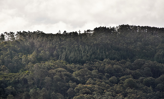
... however a few minutes further down the MRWT I was able to sit for awhile and enjoy the extensive view across the village and over to Mt Macedon (if you look really close you can just see the memorial cross on the skyline).

Camels Hump.

Dropping off Mt Towrong down the MRWT.
The Dirt.
According to my GPS I walked around 11.7 kilometres and climbed about 473 metres on what I'd call a medium-hard grade walk - it is easily possible to avoid the off piste section and continue to climb the 4wd track up to Sanatorium Lake and therefore cut off a little distance and probably drop the rating down to a medium grade walk (you might have to check out the map to see what I mean). This walk is loosely based on a walks written up over the years by Tyrone Thomas although it's not an exact replica of one walk, more like bits' and pieces of a few of his walks. I used Tyrones old mud maps along with my GPS topos on the walk this afternoon. There is no water after leaving the village however there are picnic tables at the Sanatorium Lake Picnic Ground and also at the actual lake.
Relevant Posts.

I'm about to emerge from the bush back onto Anzac Road.

Walking Anzac Road again at the back end of a nice day out.


No comments:
Post a Comment