
Shellback Island was a constant companion for much of this stroll.

Approaching the end of my beach walk at the Darby River Mouth.
Before I could even start walking today I had a bit of an epic in front of me though. Leaving home at around 5am I had a two and a half hour drive down to Darby Saddle at The Prom. Once at Darby Saddle I locked the ute, grabbed my mountain bike and set off to ride back up to the Cotter Lake Track. Now this ride was only a bit over 12 kilometres and it was mostly on bitumen so it should of been pretty cruisey however I knocked me around a little this morning. I'm not sure if it was the heat and humidity (BOM was predicting 30˚ today), or riding in my walking boots or maybe the extra weight of my pack hanging off my back, whatever the reason by the time I stashed my bike in the scrub beside the Cotter Lake Track and started walking I was already well and truly warmed up this morning.

Leaving the ute up at Darby Saddle I set off to ride back up to Cotter Lake.

At least the first section of my ride was down hill.

Crossing Darby River - I'd already pencilled this spot in for a swim when I'd return later on my walk.

Darby Swamp from the road bridge.
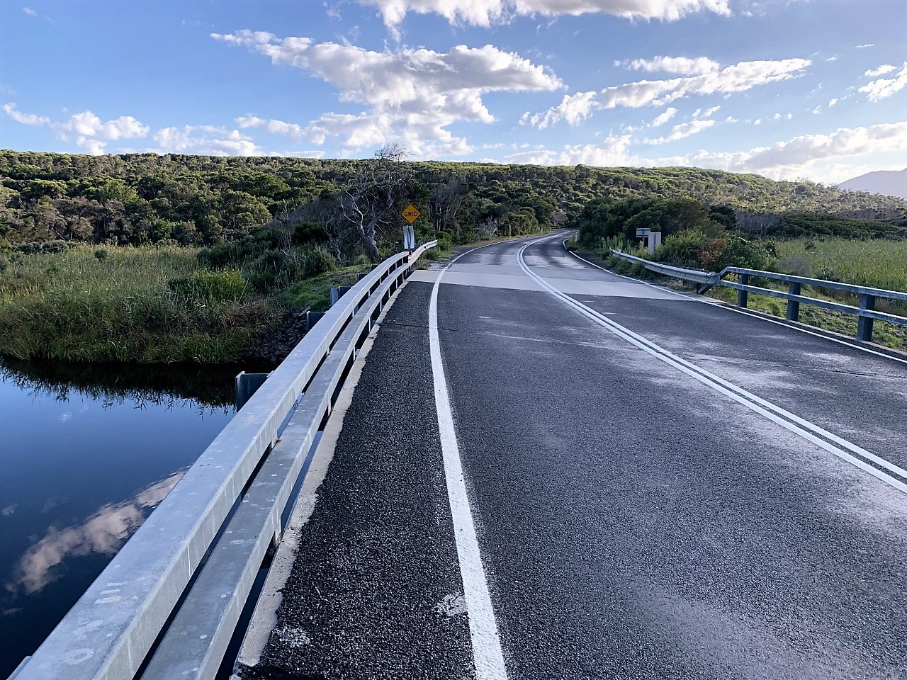
The concrete strip is where the road into Tidal River was washed away in the big 2011 flood.

I was well and truly warmed up after my ride.

I stashed my bike a few hundred metres before the Cotter Lake Car Park.
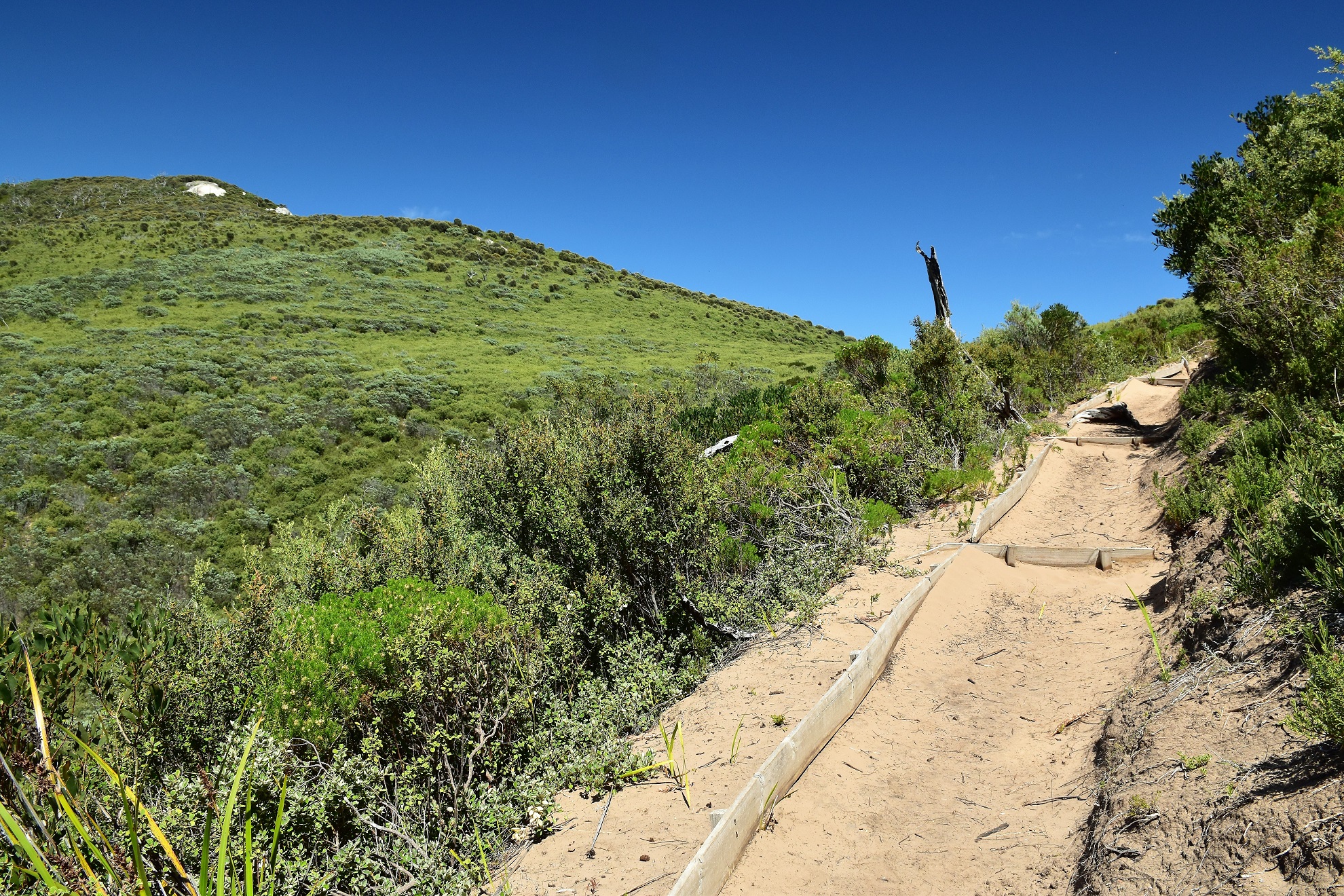
I started walking a few hundred metres before Cotter Lake Track terminates at the small car park this morning, initially following the continuation of the dirt track as it struck out west towards the shimmering waters of Bass Strait. On the way to the coast the track crossed the wide swampy expanse that is Cotter Lake, yes don't expect to see a beautiful freshwater lake here, it's more low heath and wildlife along this section. After passing to the south of a fairly large dune, the management track that I'd been walking finished and I followed a walking track the last couple of hundred metres through the coastal dunes to emerge onto the lonely and wild coastline.

I walked a few hundred metres up Cotter Lake Track to reach the official trail head at the car park.

There is a small car park near the locked gate on Cotter Lake Track.

Cotter Lake Track heading out across the dry Cotter Lake. If you squint you might see an Emu on the track in the distance.

I couldn't get a close up photo of the Emu, although they left plenty of evidence splattered on the track.

Approaching Cotter Beach the track passes this big dune.

I followed a walking track the last few metres west to meet Bass Strait.
With deserted beaches stretching into the distance in both directions and the granite Shellback Island looming out of the blue water of Bass Strait I was in a good head space now. Once on the beach it was just a matter of turning left and keeping on trudging for the next couple of hours now. I started off walking Cotter Beach towards the distant Buckleys Rock which stood out like a beacon in the middle distance. While this section of the coast has Bass Strait pounding into it, today the surf conditions were about a benign as they could be really and this was a good thing as with the day being so warm I had plans to punctuate the day with a few swims.

Arriving onto Cotter Beach - it looks like social distancing wasn't going to be a problem today.

Cotter Beach. With very firm sand this is a good beach to walk on.

Shellback Island

Cotter Beach.

Cotter Beach.

Buckleys Rock.
After passing Buckleys Rock I continued trudging down the beach towards the Darby River month. There is some reasonably sized sandstone cliffs just before the Darby River mouth so once again I had a good navigation point to gauge my progress along the sand. By the time I arrived at the cliffs I'd been walking for around two hours this morning in the unrelenting sun, so the shade the cliffs provided was very welcome indeed. While the shade was appreciated the crumbly cliffs could be a little dodgy I'm thinking so if anyone decides to rest here then make sure you stay out of the impact zone, having twenty tonnes of sandstone land on your head whilst enjoying morning smoko would put a dampener on your day I'm thinking.

Once I was south of Buckleys Rock I was walking Darby Beach I think.

I had one of The Roulettes scream down the beach - they are based in nearby Sale I think.

Darby Beach.

There are some interesting cliffs just to the north of the Darby River Mouth.

Looking back north, Buckleys Rock was just a pimple on the sand now.
Suitably refreshed after a quick break in the shade I headed off and immediately crossed the ankle deep Darby River mouth before shuffling a few more minutes south along the sand. With a huge granite outcrop ahead of me making any further progress along the coast somewhat problematical I picked up the sandy walking track that heads east to the Darby River Car Park. This track initially undulates through some vegetated dunes before contouring above the - now more substantial - inky black Darby River. Arriving at car park I found the spot where the canoes can launch into the river, stripped off and slipped into the cool fresh water, the mornings accumulated salt and sweat soon just a memory.

Darby River breaking out into Bass Strait.

Darby River Mouth.

This granite headland marked the spot that I had to turn inland for awhile.

I followed this sandy track out to the Darby River Car Park.

Darby River.

Darby River.

Swim number one today.
My GPS had once again refused to play ball this morning so unfortunately I don't have a trace of this first section of today's stroll however it kicked into life just after I left Darby River Car Park so from here on I have a bit of a map if anyone's interested. It didn't take long to drip dry in the warm sun this morning and I was soon shouldering my pack and setting off for the days next objective, Fairy Cove. The walking track from Darby River to Fairly Cove immediately climbs into the hills and stays in them until it drops down to Fairy Cove an hour later. The good news was that even though I was now grunting and sweating my way up and down hills I was also getting some first class views. Initially as I climbed the views across Darby Swamp with the sinuous Darby River snaking it's way east were quite stunning, no doubt helped by the beautiful blue sky. After crossing a high saddle I suddenly had the shimmering turquoise water of Darby Bay below me, with Shellback Island, Waratah Bay and the distant Cape Liptrap in one direction and Fairy Cove and Tongue Point in the opposite direction.

Swims done - time to head into the hills.

Leaving Darby River Car Park I picked up the Tongue Point Track and headed up into the hills.

The track climbs solidly however the views made the effort worth while.

Darby River snaking its way across Darby Swamp - The Prom was looking sensational today.
The low heath allowed for plenty of views.

Shellback Island.

Tongue Point.

After the initial climb the track sidled the steep slopes for quite a while.

Fairy Cove has just come into view - swim number two was getting closer!

The scenic Tongue Point Track.

Norman Island.

I'm about to drop down to Fairy Cove. The tracks are generally very well sign posted down at The Prom.
After sidling the steep slopes high above Darby Bay for awhile I arrived at the turn off for Fairy Cove and dropped dow. for swim number two. Fairy Cove is a stunning little beach however it's not all sweetness and light down here. The first thing to be aware of is that at high tide the beach pretty well disappears under water, the second thing to be aware of is that even coming in the easy way from Darby River requires a walk with a bit of climbing involved, and thirdly and most annoyingly for me the March Flies here are horrific - the only relief from the flies is when you are in the water. Having said that I suppose it's good news that the swimming here is stunning, with the warm temperature today the gently lapping waves and crystal clear water were definitely hard to leave.

Fairy Cove - that water was calling me in!

At least I wasn't offending anybody with my skinny dip!

Fairy Cove.

Here's my Fairy Cove arty blogger selfie.

The water was a beautiful temperature today.

Fairy Cove.

Out past the shore break at Fairy Cove - this was probably the safest spot that I swam at today.

Fairy Cove - it was time to pull on my sweaty clothes and set off again.

Fairy Cove - the beach here pretty well disappears at high tide.
The worst thing about the March Flies are the way they attack when your hands are busy doing something else, so needless to say pulling on my socks, boots and gaiters after my swim at Fairy Cove was a fraught affair this afternoon. Thankfully after much swearing and wild swatting I was dressed and shod again and on my way out to my next destination, the tip of Tongue Point. After passing my return track heading off left up to Darby Saddle the Tongue Point Track struck out across of open heathland towards the end of the point. While the low coastal heath provided next to nothing in the way of shade from the sun it did allow for great views up and down the coastline, with the huge granite slabs buttressing Mt Oberon drawing the eye to the south. With the land dropping away steeply on either side of me I arrived at the end of the track, although somewhat anti climatically there is another big granite outcrop blocking the view off the point here. I wasn't really too worried about the huge expanse of granite infront of me though, no I was busy checking out a route down to the water level as it was time for swim number three!

It didn't take long to warm up on my climb away from Fairy Cove.

Back on the Tongue Point Track - there isn't a lot of shade out here.

The moon's coming up. I didn't realise I'd been walking that long!

Mt Oberon in the distance.

Tongue Point.

Looking back towards Darby Beach from Tongue Point.

The view south from Tongue Point.

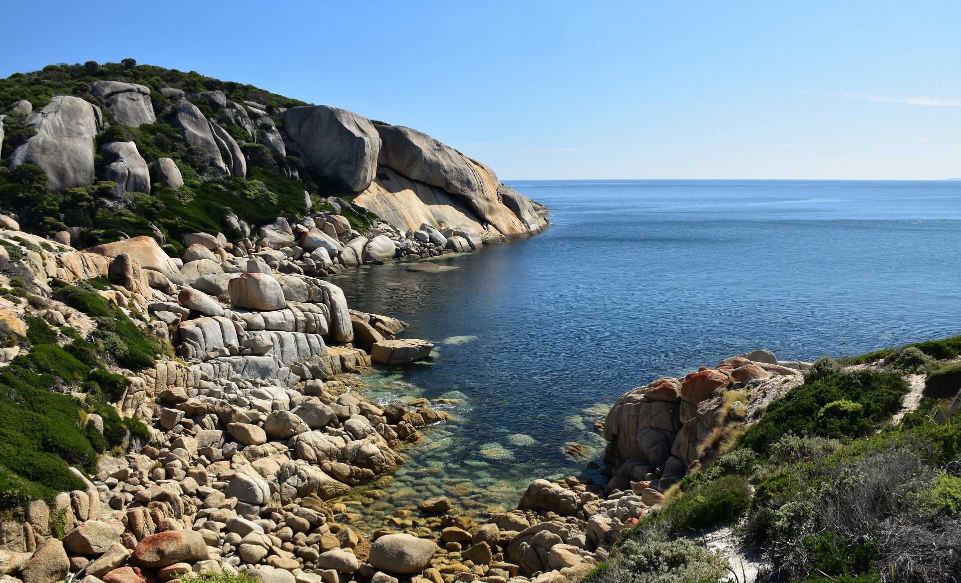
Tongue Point - it wasn't overly hard to get down to the water level here.
Swim number three was another beauty, if I'd had some goggles it would of been even better I think as the visibility in the deep water was superb. I'd managed rock hop down to water level along a short rocky spur basically right at the end of Tongue Point and the crystal clear water made for great swimming. Now I've got to honest here, I take the piss out of myself a fair bit however I'm a fairly competent swimmer so I really wouldn't advise swimming in a spot like this unless you can read swells and rips as well as handle yourself in deep open water. The good news for me was that not only was the entry and exit off granite rocks which meant I could wash all the sand off my feet before my big up coming climb, but also the March Flies here weren't quite as ferocious as they had been back at Fairy Cove.

Swim number three was another stunner.

It was straight into deep water here.

The bloody March Flies weren't quite as bad here - although by the look of it I still had one land on my knee even though I was floating in Bass Strait!

Next time I'm bringing some swimming goggles.

Good times at Tongue Point.

The tip of Tongue Point from my swimming spot.
After drying off on the rocks for awhile I set off on what would be the crux of today's outing, the climb up to Darby Saddle. I've done this climb before a couple of times and it's a solid walk, however today I was doing it at the back end of what had already been a very big day and that combined with the late afternoon heat had me thinking that the rest of my walk was going to be a slow affair. Retracing my outward route along Tongue Point I reached the turn off for Darby Saddle and started climbing almost immediately. Now I'd like to say that the climb wasn't bad, except for the fact that it was a real bitch! Not only was the climb unrelenting but also a recent bushfire had knocked out all the substantial vegetation so I was fully exposed to the western sun as I climbed up through the low heath. By the time I reached the larger trees higher up I was pretty well shagged out this afternoon so it was with some relief that I dropped my pack in the shade for awhile whilst I took in the view back down to Tongue Point.

Alright the afternoons hard work has begun - first up I had to climb up to pick up the Tongue Point Track.
Tongue Point.

That's the Darby Saddle Track snaking up the hill.

By the time I reached the tree line...

... I was pretty well cooked!
I wasn't going to get back to the ute sitting on my fat arse though, so somewhat reluctantly I shouldered my pack again and resumed my climb. Things were a little more pleasant now as even though I was still climbing solidly I was now sheltered a bit from the warm afternoon sun. Reaching Lookout Rocks most of the substantial climbing was over and I climbed a few metres off the track to the rocks to check out the views back down to Tongue Point. After leaving Lookout Rocks my track dropped through a high saddle before I once again climbed, this time to meet a track junction where I once again took a side trip - this time out to Sparkes Lookout. Sparkes Lookout offers a similar view to that of the one back at Lookout Rocks however it also allowed my to get a look all the way back down over Darby River to Cotter Beach where the days walk had started. At a bit over 300 metres Sparkes Lookout pretty well marked the end of any real climbing for the day and the track now sidled some steep slopes and headed east towards Darby Saddle, there are some nice views down towards Tidal River and the southern section of The Prom through the trees along here however for the most part it's a forest walk. It was around 6:30 pm when I finally emerged from the bush at Darby Saddle tonight and I was a very tired walker after what had been a long day. Jumping in the ute I cranked up the air conditioner, skulled half a litre of luke warm Pepsi Max and then set off to retrieve my mountain bike and head off home.... arriving home a very satisfied and tired walker at around 9 pm after a 16 hour day out.

Thankfully the track offered a little more shelter from here on.

Bass Strait from Lookout Rocks.

Tongue Point from Lookout Rocks - progress was still being made!

Looking south from Lookout Rocks.

Looking into the late afternoon sun towards Tongue Point from Sparkes Lookout.

Looking back at my days walking from Sparkes Lookout. Cotter Lake is near the middle section of sand dunes.
The Dirt.
Ok, as you may have gathered this was a big day out. According to my GPS (and maps) I walked around 20.6 kilometres and climbed around 696 metres on what is a hard walk. If anyone wants to do the bike ride then that adds another 12.4 kilometres and 85 metres of climbing (it felt a lot more than that!). I stashed my bike a few hundred metres before Cotter Lake Track terminates at a small car park and it was still there when I got back so I suppose that was a success. The walk mostly follows beaches and walking tracks although there is a kilometre or two on the Cotter Lake Road (a closed 4wd track). Now swimming is a real feature of this walk however it's not all without risk. Swimming in Darby River at the car park is very good however it drops off very quickly into the dark tannin stained water. Fairy Cove arguably offers the safest swimming spot that I sampled today although it is a surf beach so it still needs to be treated with a bit of respect, another thing to be aware of at Fairy Cove is that the beach pretty well disappears at high tide. My third swim was off the tip of Tongue Point and this spot drops straight from the granite rocks into deep water, that meant that I was not only dealing with the swell but also currents so don't consider jumping in here unless you are a competent swimmer (I feel like such a wanker prattling on about this however there are so many people drowning in Australia now days that I have to be a bit blunt!). I used a set of Tyrone Thomas' old notes and mud maps out of his book 150 Walks in Victoria along with an old 1:50,000 topo VicMap and my GPS topos today.
Relevant Posts.

My late afternoon view over Bass Strait.

Shortly after taking the short side trip up to Sparkes Lookout the Darby Saddle Track swung around to the east and levelled off a fair bit.

I got some more glimpses south through the trees.

Easy going as I approached Darby Saddle.

Back at Darby Saddle. Time to crank up the air-con, skull some lukewarm Pepsi Max, retrieve my bike and set off home after what had been a sensational day out.


epic
ReplyDelete