I was still climbing Stanley Name Spur as the sun set tonight - it wasn't part of the plan however it had it's good points!
My day had started off OK, a few hours at work, a long drive up through Mansfield and then up to TBJ by early afternoon. Taking the Circuit Road around to Bindaree Road all was still good however things started to fall apart a little when I arrived down at the Bindaree Falls Carpark to find Bindaree Road closed between the falls and the Upper Howqua Carpark. I'd checked the Parks Vic website before leaving home however this bit of the road is in the Mansfield State Forest which falls under the management of DEWLP so I guess that they had something on their website? Whatever the case there was no signage at all up here until I arrived at the closed bridge - even a sign at the top of Bindaree Road would been helpful.
This was a little sub-optimal!
It was almost 5pm when I finally set off today.
The track drops to cross the Howqua River immediately.
Late afternoon on the Howqua River.
The old track is pretty good along the valley.
Howqua River
Howqua River
The Howqua River splits here and the Queens Spur Track starts to climb high up above the north branch of the river now. Initially the wide benched track was pretty good walking as I got some nice views back down into the fern filled valley that the Howqua flows down. It wasn't too long before the old Queens Spur Track left the river and started to climb a little more and it's along here that the blackberries are at their worst, a couple of the gullies were particularly gnarly. Thankfully though I was more or less able to get through the thickets of prickles without getting too cut up, it has to be said though that while gaiters aren't exactly the height of fashion they come into their own when pushing through country like this. To take my mind off the blackberries a bit I was getting some views through the trees of the sun lighting up the surrounding rocky bluffs now so things weren't too bad really, although it was pretty obvious that I'd doing a bit of night hiking tonight.
The old Queens Spur Track climbs above the north branch of the Howqua River.
Climbing Queens Spur Track.
I was starting to get glimpses through the trees up towards the higher country.
The blackberries on the Queens Spur Track were a little intense in a couple of spots.
The view from near the top of the Queens Spur Track.
Pushing through some re-growth near the saddle on the Queens Spur Track.
There is no sign at the start of the climb up the Stanley Name Track...
... although there might be a Timbertop Nalgene bottle in the grass.
This is the Stanley Name Track that I was looking for.
There are some nice openings heading up Stanley Name Spur.
Stanley Name Track is a little overgrown down low but still followable with a bit of care.
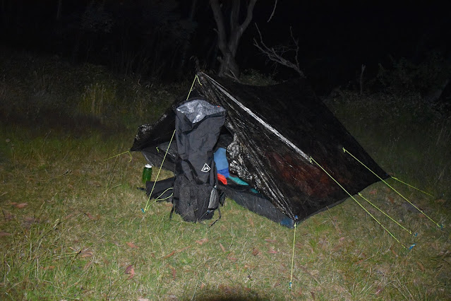
Stanley Name Track crosses a few grassy openings as well as climbing a few rocky outcrops so the views were now taking my mind off the climb a bit, although the gathering gloom was focusing my mind a bit. Eventually I figured that I'd better pull out the head torch as it was now getting a little hard staying on the pad as it pushed through the encroaching scrub. With the light on, my field of vision was suddenly confined the bright beam of light that danced around ahead of me. It was around 8:30pm when I walked out into a bit of a grassy opening that had obviously been used to camping, spying a rough pad dropping into the bush on the north side of the spur I shuffled down to see if I could find my water source. With the sound of rushing water to guide me in, I successfully located the creek before retracing my steps back up onto the grassy flat on the spur. After getting the tent up and cooking up some dinner it was well past hiker midnight when I crawled into my quilt tonight (around 10pm).
One of the advantages of still walking as the sun goes down is definitely the light.
It was getting pretty dark by now.
I got one last look across to Mt Howitt before I lost the light altogether.
Time to dig out the head torch.
The Dirt.
According to my GPS I walked around 11 kilometres and climbed around 625 metres on what I'd call a medium grade stroll. The track conditions this afternoon varied from pretty good along the Howqua River to pretty ordinary in spots as I pushed through the blackberries on the old Queens Spur Track. The Stanley Name Track is taped in spots and is a little vague down low as the bush crowds out the pad a bit, it's followable however it needs a little concentration. Higher up Stanley Name Track the spur gets more acute so you really can't go too far wrong. The Stanley Name Camp really only consists of a flattish grassy area in a saddle there are a couple of logs around to sit on and water is easily available down a rough pad 5 minutes to the north. I used the old Vicmap Howitt - Selwyn 1 : 50,000 topo sheet today.
Relevant Posts.
Once I'd found my water source I settled in for the night.
My Stanley Name Spur Camp.
It was way past hiker midnight when I crawled into the quilt tonight.


No comments:
Post a Comment