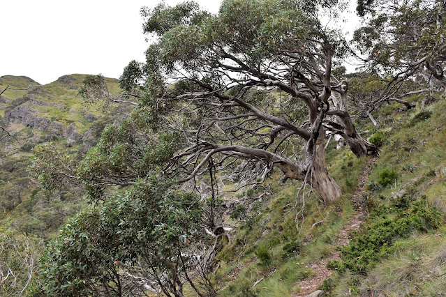
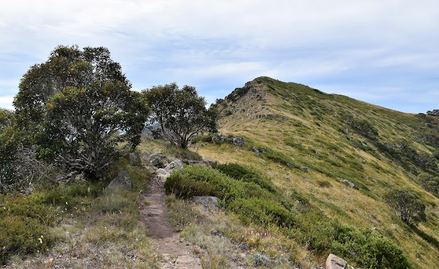
Looking west towards The Bluff from Mt Howitt - this is an epic view I reckon.
There are some good views across to Mt Howitt from camp.
Follow the rough pad heading north off the spur for water.
According to my map this is the headwaters of the South Branch of the King River.
Alright... time to start climbing again.
I was able to get up close and personal with the scrub again when I set off, however it didn't last long and for the most part today the tracks were pretty clear.
The climb up to the Cross Cut Saw was steep in spots...
... although the expanding views gave me plenty of reasons to stop.
When I went through there was some blue flagging tape marking the safest route through the bluffs... although the small cairns aren't there anymore.
Looking across towards Mt Howitt on my Stanley Name Spur climb.
The scrub had stopped by now however the climb was still slowing me down a bit!
Stanley Name Spur, Alpine National Park.
The crest of the Cross Cut Saw is getting fairly close now.
There are some nice mature Snowgums up here.
I've joined up with the AAWT on the Cross Cut Saw - happy days!
Looking east off the Cross Cut Saw towards The Razor and The Viking in the distance.
Good walking on the AAWT this morning, although the drab grey sky wasn't helping my photos much.
Looking back along the Cross Cut Saw.
The AAWT on the Cross Cut Saw.
The AAWT is pretty good going along here, sometimes it sidles the teeth while at other times the track goes over the top and each of these high points are worth stopping at the check out the view, the huge cliffs of The Devils Staircase being a particular highlight when you are heading in this direction. Eventually the AAWT left the high ridge and after avoiding the track heading off down to Macalistair Springs I set off across the rolling alpine grassland towards the summit of Mt Howitt. Like a few of the other high points in the Victorian High Country the summit of Mt Howitt is a high point on a bit of an undulating plateau, although the 1742 metre summit offers one of the best outlooks in Victoria I think - the views west along the rugged ridge line to the distant Square Head Jinny and The Bluff being particularly epic.
Devils Staircase.
Cross Cut Saw views.
Mt Howitt is another of those flat topped mountains.
The West Peak of Mt Howitt.
The view from the summit of Mt Howitt.
The summit made a nice spot for a bit of a rest today although the wind chill meant that it was good that I had a rock to shelter behind.
The wind had come up a bit now so I enjoyed any quick break on the summit sitting in the lee side of a rock on the snow grass. I was a little surprised to be the only person on the summit as I'd probably passed twenty people since arriving up on the Cross Cut Saw, not that being on my own worries me unduly! Rehydrated and fed I grabbed my pack and set off on the long decent back down to the Upper Howqua Carpark now. After following the AAWT for a few minutes I branched off onto the Howqua Feeder Track and meandered over to West Peak before starting my plunge down into three valley. The upper sections of this track are steep and exposed in spots although the views across to the Cross Cut Saw and Mt Magdala make the pain worthwhile I think (almost;).
Hmm... looks like I've got a bit of a descent ahead of me.
Following the Howqua Feeder Track across to West Peak.
Looking back towards the jagged Cross Cut Saw from near West Peak.
I'd climbed that spur in the middle distance this morning.
Zooming in a little I think that small opening was my Stanley Name Camp last night.
Some people who are much braver and skilled than me had recently bought horses up here and while I had to admire their skill they had made mess of the walking track in spots. The horses had dug up the track as well as created numerous braids as they tried to get around the gnarlier rocky sections higher up. The Howqua Feeder Track eases off a bit as it drops although it's still by no means an easy walk (well, for this fat old bloke anyway!), although as things get a bit easier the views get a little thinner on the ground as the track passes through some dense and thick regrowth lower down. Eventually my descent bottomed out and I splashed my way across the Howqua River South Branch and a couple of minutes later arrived at the Queens Spur Track turn off to complete the circuit section of my stroll.
Dropping off West Peak the Howqua Feeder Track is pretty steep.
The Howqua Feeder Track.
Looking back up towards West Peak - it appears that the sun has come out a little to late for me today.
There are some nice views across towards the Cross Cut Saw from the Howqua Feeder Track.
There was a fair bit of braiding in spots where horses had been bought up the Howqua Feeder Track.
Lower down the Howqua Feeder Track there are some good views across to Mt Magdala.
All that was left of my walk now was to walk the last few kilometres down the Howqua River back too the carpark. Instead of changing into my Teva's I decided to complete the walk in my boots figuring that even if they got wet on the numerous river crossings I wouldn't have too far to go to get back to the ute, and a bit of fresh water washing through my boots wouldn't hurt them too much. Maybe not walking in Teva's was a wise choice this afternoon as I had my most notable wildlife encounter just before getting back to the ute... with a Copperhead! After safely negotiating the river crossings and the snake I arrived back at the Upper Howqua Carpark in the early afternoon and after a quick soak in the river to rinse off the accumulated dust and sweat I set off for home feeling pretty good about life after another nice walk.
Lower down the Howqua Feeder Track passes through some thick regrowth.
Crossing the South Branch of the Howqua River meant that my long descent was pretty well over.
Following the Howqua River back to the Upper Howqua Carpark wasn't without its attractions.
The Howqua River, Alpine National Park.
The Dirt.
According to my GPS I walked around 14.1 kilometres and climbed around 576 metres on what I'd call a medium grade day out. The climb from my camp up onto the Cross Cut Saw was a little rough in a couple of spots and featured some easy scrambling, however it wasn't too bad really. Once on the AAWT on the Cross Cut Saw I followed it all the way around until the Howqua Feeder Track branched off west of the Mt Howitt Summit, the AAWT along here is clear and fairly easy. Once on the Howqua Feeder Track I followed it all the way down to the Upper Howqua Carpark and while it's easier enough to follow its a fairly steep descent, especially the drop down of Howqua West Peak. Once again today I used the old Vicmap Howitt - Selwyn 1:50,000 topo sheet.
Over the two days of this walk I shuffled around 25.1 kilometres and climbed around 1201 metres according to my GPS. The toughest bit of this walk was arguably on day one when I climbed the old Queens Spur Track and on the initial climb up Stanley Name Spur, both these sections were a little scrubby when I went through. Day two was a solid day out without ever getting too hard, the climb up to the Cross Cut Saw from my camp required a couple of easy scrambles and a little bit of easy route finding on rock. If anyone out there has done all the other popular routes in the area and is looking for something different then this one might be one to consider I suppose. The camp on Stanley Name Spur is a very good one too, the views are pretty sensational here and water is easy to access. Some of the old time bushwalking authors have written up this walk in published books over the years however as the country has changed so much with fire and floods in the last ten years or so the old notes are mainly best used for inspiration I think.
Relevant Posts.
The third last last crossing.
Easy going along the Howqua River on the Howqua Feeder Track.
Maybe keeping my boots on was a good idea this afternoon!
One last crossing and it was time to head off home... after a swim!


Hi nice report , how long approximately did it take to walk from SNS Camp site up onto the crosscut? will try this route on the weekend but heading straight to Mt Buggery for camp.
ReplyDeleteCheers