
Kirk Point.

Looks like social distancing won't be an issue this afternoon.
Leaving the ute I walked a couple of metres towards the coast before swinging south along a rough 4wd track that parallels the shoreline. This rough and muddy 4wd track follows a drainage channel that was built in the ye olde days when the early settlers drained the coastal salt pans to facilitate farming, basically the country on the inland side of the drain now agricultural land while land on the coastal side being the more natural salt marshes. After judiciously making my way through some substantial bog holes I passed by an old Cypress Tree in a nearby paddock that marked the spot of an early homestead, although even though there was an old bridge leading across the drain to the homestead site it was on the opposite side of a fence, so I decided against heading over to check things out as I wasn't certain on the legalities and I'm a stickler for rules!

I left Beach Road and followed this 4wd track that runs along the coast parallel to the beach.

Kirk Point Salt Marsh.

This wasn't the most scenic walking that I've ever done.

The old trees in the paddock mark the site of an old homestead.

The 4wd track follows this old drainage channel.
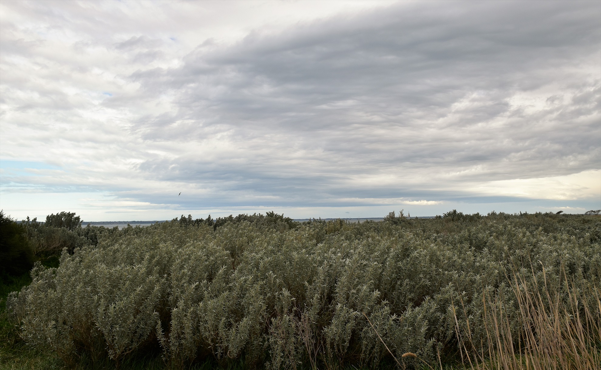
After missing out on checking out the old homestead site I meandered my way a little further along the 4wd track and checked out the a shipping beacon, yes it was that kind of walk. The slightly drunk looking shipping beacon marks Kirk Point, a more windswept and desolate spot on the shoreline of Port Phillip Bay you would be hard to find I reckon. The salt tolerant scrub around Kirk Point was probably the highlight of this walk I'm thinking, these hardy colourful plants alway come up well in photos, although the looming grey clouds weren't doing me any favours this afternoon.
Kirk Point.

Looking across the windswept plains towards the You Yangs - from Kirk Point.

Kirk Point Salt Marsh.

Kirk Point is home to a shipping beacon.
After passing behind Kirk Point I continued along the 4wd track for a few more minutes until I arrived at a no entry sign that marked the start of a area that was for the protection of waterbirds. So now I left the rough 4wd track and dropped 15 metres onto the narrow beach and started my return journey to the ute. Before starting my return walk though I took the opportunity to enjoy both the views across the plains towards the You Yangs and also the views along the coast and across the water towards the Bellarine Peninsula - having never set foot on this part of Port Phillip Bay before it provided an interesting perspective.

Kirk Point.

Kirk Point.

This was as close as I'd get to the You Yangs this afternoon.

My turn around point.
Shuffling my way back along the coast meant that I was crossing lengths of firmish sand, interspersed with soft and smelly sections of sea weed along with the occasional rocky sections, yes it wasn't the best coastal walking that I've ever done however it was interesting in it's diversity alone. After rounding Kirk Point on some rocks I disturbed some fisherman out collecting shellfish, these blokes almost walked on water to get back to their cars as I approached along the beach - maybe that had something to do with the DSLR hanging around my neck along with the numerous signs prohibiting collecting shellfish - or maybe they just didn't want to chat?

The coastline down towards Corio is a no go zone.

I was now heading back along the beach towards Kirk Point.


Walking through this deep and smelly seaweed wasn't ideal.

Kirk Point.
After passing by what looked like an old rusting engine block I waded the last few metres along the beach through a particularly deep and smelly section of sea weed and climbed up onto the Kirk Point Boat Ramp. Things are pretty low key over this side of Port Phillip Bay and the Kirk Point Boat Ramp is the classic example of that I think, some old car tyres, a length of rough concrete lined by a few rocks is about the extent of the infrastructure at this boat ramp. The Kirk Point Boat Ramp did allow for probably my best look across the grey water of Port Phillip Bay towards the high rise buildings of Melbourne's CBD though, so that's something. After taking the obligatory photo I shuffled my way back along Beach Road for a few metres to complete my loop before throwing my smelly boots (remember the deep seaweed) in the back of the ute and heading off for home.

It looks like some of my responsible shooter brothers have been down here with their 12 gauges sorting out those pesky waterbirds.

There was quite a few of these Protected Shell Fish Habitat signs around...

... which might explain why these blokes bolted for their cars when they spotted me rounding the point?

Kirk Point.
The Dirt.
According to my GPS I walked around 3.7 kilometres and climbed about 29 metres (which seems a little optimistic!) on this easy stroll. This isn't a walk for everyone, the 4wd track is rough and was muddy today, the coastal section is narrow and has some soft sections of deep and smelly seaweed and I'm thinking that if there was no wind then the sand flies would be ferocious - that said, if you are walker based to the west of Melbourne and you are looking for somewhere a bit unusual and away from the normal walking destinations then Kirk Point is worth a look. This is also a renowned bird watching area so if you are a twitcher then it might be worth a visit too. I used the notes and map out of Julie Mundy book Best Walks of Geelong, the Bellarine and the Brisbane Ranges along with my GPS topos.
Relevant Posts.

Mounds of stinking seaweed... yes it was a different kind of walk.
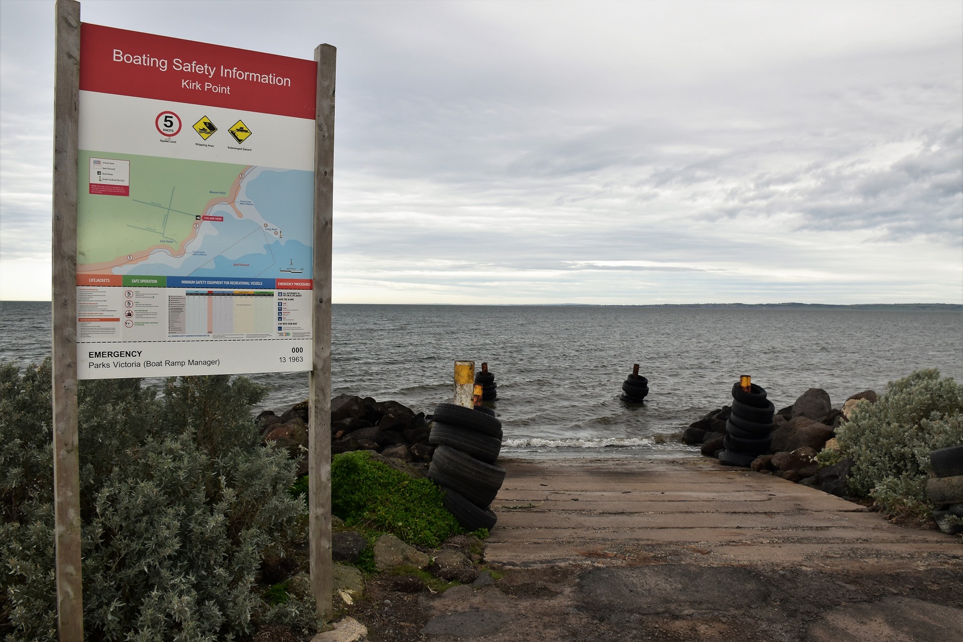
Things are pretty low key at the Kirk Point Boat Ramp.

The Melbourne CBD from the Kirk Point Boat Ramp.

Heading back up Beach Road to the car park - the crowds still hadn't arrived.


No comments:
Post a Comment