
Hey, hey, our 2021 lockdown season is starting to lift!

I dusted the cobwebs off the ute and headed for the hills - and ended up at Kurth-Kiln Regional Park very early this morning.
The sun was still to make its appearance when I set off this morning. Crossing the dewy grass I picked up the start of Thornton Walking Track at the tree line and slipped into the bush, immediately feeling more at ease than I have for months as I followed the soft, leaf littered walking track. The Thornton Walking Track mostly contoured along the sides of the hills above Tomahawk Creek as I made my way east towards the Scout Loop Camping Area. I guess it was might be due to our long lockdowns, whatever the cause was I was really savouring every sight, smell and noise this morning - everything from the first rays of the rising sun kissing the trees to the sounds of the Lyrebirds hidden away in the scrub and even the slightly musty smell of the damp bush, had me stopping to take it in.

I even had a real walking track to follow this morning.

Thornton Walking Track.

Maybe it was just me however the bush was enchanting this morning.

The rising sun was making its presence felt.

Kurth-Kiln Regional Park.

Thornton Track.

Kurth-Kiln Regional Park.

I look old pretty happy with life.

Mountain Ash, Kurth-Kiln Regional Park.

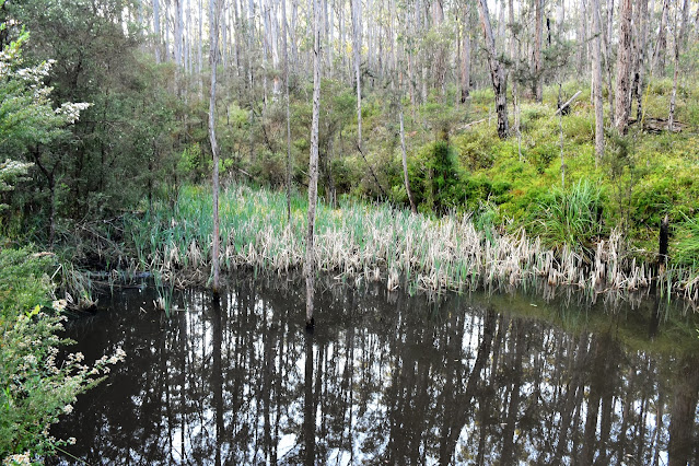
Tomahawk Creek.

The Scout Loop Camping Area was locked up and deserted...

... except for this strange set up (behind the locked gate?).
I now started walking a series of closed 4wd track as a completed an arc around the park. After following Cramer Track for a few minutes I swung west along Woodduck Track for a few minutes before swinging south along Kurth-Kiln Track for awhile. With the sun now well and truly up it was bathing the open forest in a nice soft light, the scene enhanced by the amount of wild flowers in bloom. With the sound of traffic on the Gembrook-Launching Place Road getting closer I swung away from the road and started to head back towards the ute via yet more closed 4wd tracks before crossing over Beenak Road and walking the more substantial gravel Shepherds Creek Road. Walking along Shepherds Creek Road was actually pretty nice this morning, the road contours along the hills with Shepherds Creek running through the gulley below, the moist gully being home to substantial numbers of towering Mountain Ash trees which were all easily visible from the road.

Soldiers Road.
A Bunyip hole off Cramer Track.

Cramer Track.

Kurth-Kiln Regional Park.

Kurth-Kiln Track.

I'm thinking that this is Coral Fern??

Kurth-Kiln Track.

Gilwell Track.
After following Shepherds Creek Road north for awhile I turned east at the signposted Tomahawk Creek Walking Track. Once again I was now walking a designated walking track as I followed Tomahawk Creek up stream towards the Kurth-Kiln Picnic Area, taking the right hand branch where the track split. With some good spring rains having fallen in Melbourne recently Tomahawk Creek was looking very nice today, with a good flow of water gushing downstream. There are a couple of spots along here where you can access the water, however it would pay to be careful as the rocks and the creek banks are incredibly slippery (or they were this morning). Arriving back at at the picnic area this morning I resisted jumping into the ute and heading home now, instead after checking out a small swimming hole in Tomahawk Creek I set off on another loop into the park.

Mountain Ask along Shepherds Road.

Shepherds Road.

Mountain Ash.

Mountain Ash.

Tomahawk Creek.

Tomahawk Creek Walking Track.

Tomahawk Creek.
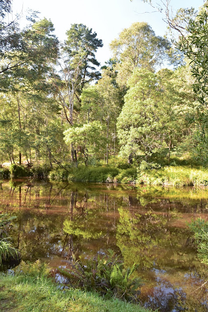
There is a nice dam at the picnic area...

... as well as a small swimming hole - below Beenak Road.
On my second loop in Kurth-Kiln Regional Park I climbed Beenak Road away from the picnic area for a few minutes before dropping north down the closed Possum Track. Possum Track is an arrow straight track initially which meant that for the first time this morning I had some decent hills to negotiate as the track headed straight over the higher spots. After twenty minutes or so Possum Track dropped down into a damper gully and swung north-westerly - I now started to encounter quite a few downed trees that were no doubt the result of Melbournes huge June storms. Arriving at Monkhouse Track I made a short detour to check out a pretty dam before starting a long but gentle climb, first up Monkouse before swinging left onto Manna Gum Track.

Possum Track swinging left of Beenak Road.

Possum Track.


I started to encounter some fallen trees on my northern loop.

There was a nice dam down the bottom of Possum Track.

I missed this track initially.

Wading through bracken as I made my way around fallen trees along Spotover Track.

Spotover Track.
After twenty minute slog I eventually emerged, a little bloody and battered, but still pretty happy with life onto Short Cut Track and walking got easier again. Short Cut Track did have one sting in it though, it provided the steepest climb of the walk although thankfully it was a fairly short little grunt. Once I'd topped out on Short Cut Track my mornings walk was as good as over, after an easy downhill ramble I passed the locked gate and once again re-joined Beenak Road, the ute easy visible now a hundred metres down the road at the picnic area.

Short Cut Track featured one decent climb.
The Dirt.
According to my GPS I walked around 13.2 kilometres and climbed about 396 metres on what I'd call a medium grade walk. As I've already waffled on about this walk was mostly all along clear and distinct tracks, with the exception of around 800 metres along Spotover Track which is quickly returning to nature and requires some resilience to walk. One other thing to be aware of here is that it's a state park and these places are magnets for my bogan brothers and sisters, so if you are looking for a bit of peace and quiet then maybe try and head out here on a week day if you can - I didn't see a soul on this walk, however I'm thinking the weekend would be pretty busy (especially as our lockdown restrictions start to ease). I found this walk on Alltrails and used their map along with my GPS topos and Rooftop's Yarra Valley - West Gippsland Adventure Map.
Relevant Posts.

I'm just re-joining Beenak Road, the ute is in site.


No comments:
Post a Comment