 |
| This bloke hung out with me for awhile at the back end of the day. |
I’ve had a walk up to Mt Langhi Ghiran in the back of my mind for quite awhile. I’ve had a cunning plan floating around the dark recesses of my mind which went something like this….I was thinking that I could make this walk into a two day amble and bivy on the summit for the night, the only thing was I wasn’t actually sure how much flattish ground that there was on the summit, from a distance things didn’t look overly promising and 'a distance' is as close as I’d ever got to the Mt Langhi Ghiran summit.
Luckily I knew of someone who had actually set foot on the summit before, yep, the Hunter S. Thomson of gonzo Bushwalking Blogging, Mr Fiasco. I remember reading an old post of his incident filled and piss funny Mt Langhi Ghiran Walk, back in the golden age of Bushwalking Blogging. So anyway, after checking with Mr Fiasco about the likelihood of having enough flat ground to lay down in the vicinity of the summit and getting a fairly positive answer I decided that the walk could be a goer. With the weather on this Friday and Saturday looking about as good as it gets I decided it was time to finally get up to Langhi Ghiran State Park and check things out.
 |
| It was already well into the afternoon when I set off today, not that it mattered much as I didn't have far to go really. |
So after a few hours at work I pointed the ute up the Western Highway and headed towards Ararat, being mightily entertained on my drive up as the conservatives tried to tear themselves to pieces on the radio, life was about as good as it gets! It was early afternoon by the time I finally set off and we now had a new PM, yep the bloke that waved a lump of coal around on the floor of parliament, fuck..... and he was the ‘good’ choice! Grabbing my pack I set off up the well signposted walking track towards Langhi Ghiran Reservoir.
 |
| Climbing away from the car park I was straight into rocky country. |
The reservoir that I was climbing up to was built in 1880 from locally quarried rock but there isn’t just European History up here. Langhi Ghiran was part of the traditional lands of the Djab Wurrung People and the name they gave the mountain was Lar-ne-jeering which translates to ‘home of the black cockatoo’. There is a short walk to some rock art in the south of the park but for today I was checking out the more recent European history, firstly a small reservoir in a steep sided gully and then a little further on the more substantial Langhi Ghiran Reservior. The reservoir is still in use today supplying some of Ararat’s water needs so I’m thinking that swimming is out of the question here, although it certainly would be tempting in the warm weather I’m thinking.
 |
My walk today followed old water infrastructure for a fair while.
 |
Passing above the first, smaller reservoir.
 |
This would have to be the most substantial stile that I've ever come across I'm thinking.
 |
| The track gets a little feint crossing these rocky outcrops but it's never hard to find again. |
|
|
|
After passing around the eastern side of the reservoir I tracked to the right a little and picked up another very good walking track, this time the track was climbing beside an old water race which, as with the reservoir, was built with local hewn rock. The old water race is quite an impressive piece of old infrastructure, it is certainly one of the more interesting water races that I’ve walked in Australia. Even though it was still only mid afternoon the late winter sun was already lighting the surrounding scrub in a nice golden light, this was a good thing as I’d been climbing since leaving the ute so I was appreciating the opportunities to stop, take a photo or two and get my breath back at the same time. Eventually I arrived at the end of the water race at a spot called Pipeline Lookout, I was excited to climb this little lookout and look down over a wind farm below me, little did I know that this wouldn’t be the last wind mill that I’d photograph before getting back to the ute tomorrow.
 |
The Langhi Ghiran Reservior would be a tempting spot for a swim in the warmer months, it still supplies water to Ararat though, so I'm guessing that swimming is off the agenda.
 |
After leaving the reservoir I continued to climb, now beside this beautiful old water race.
 |
 |
Pipeline Lookout offers a few glimpses through the trees.
 |
| It would turn out that this wasn't the last wind mill that I'd gaze down upon. |
|
|
|
|
Leaving Pipeline Lookout I followed the 4wd Pipeline Track for a few minutes before turning south-east up the minor Easter Creek Track. My climb up Mt Langhi Ghiran got a little more strenuous now, Easter Creek Track climbing steadily up past some impressive granite slabs as it headed towards the crest of the summit ridge. Dropping my pack next to the cairn that signalled the spot that I had to head off track up the ridge, but before heading for the summit I wandered a bit further along Easter Creek Track in search of another old water race.
 |
The junction of Pipeline Track and Easter Creek Track. I'd come in on the track on the left and was climbing up through the locked gate on Easter Creek Track, on the right.
 |
Climbing Easter Creek Track I passed this old relic rusting in the bush, I'm thinking it's and old boiler or maybe a water tank.
 |
I'm about to top out on Easter Creek Track.
|
|
|
Somehow I managed to completely miss the old water race as I continued on along Easter Creek Track but I did manage to find a flowing creek, this creek would be the only flowing water that I would come across for the whole walk. On reaching the creek I reluctantly accepted that I’d missed the water race that I was looking for and decided to head back to my pack. This little side trip not only provided me with a water top up but also gave me another great look at the large granite outcrops crowning the summit ridge line, it was while checking out some of these outcrops that I stumbled upon the old water race, complete with old terracotta pipes, that I’d been looking for, kind of makes you wonder how I’d missed it on the way out…?
 |
I missed the old water race that I was looking for but found a nice creek with a good flow of water.
 |
 |
| Wandering back to pick up my pack I found the remains of the old water race that I'd been looking for, complete with terracotta pipes. |
|
|
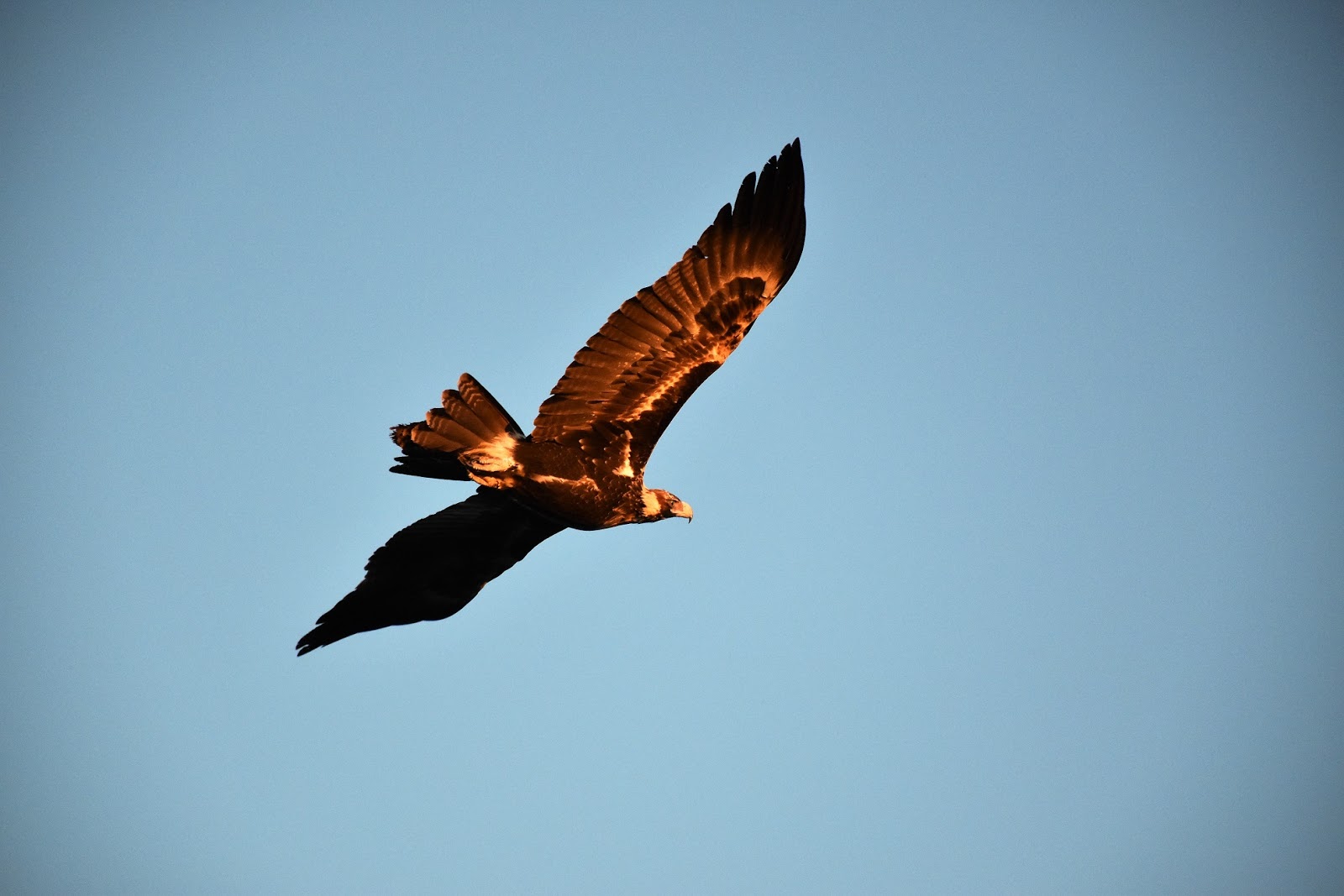
Back on the ridge crest again I grabbed my pack and set off for the summit, my route to the summit from here being more or less off piste. Whilst there wasn’t much in the way of a pad, especially higher up when I was climbing on granite, navigation was pretty straight forward, I just stayed on the crest of the ridge and kept climbing until I topped out on the summit. I really enjoy this kind of walking and today was no exception, higher up I was climbing sloping granite slabs and terraces and, as you would imagine the views were far reaching. To make my late afternoon climb even more enjoyable I had the company of a beautiful Wedgetail Eagle, the eagle would spend the best part of the next two hours soaring on the thermals in fairly close proximity to me.
 |
This is the cairn that marks the spot to head up the ridge towards the summit of Mt Langhi Ghiran.
 |
There is no real track on the climb to the summit, but the scrub is pretty light.
 |
As you would expect the views got better as I climbed....that's Mt Cole.
 |
| Climbing up these granite slabs made for great walking. |
|
|
|
Arriving on the small summit I was happy to find almost the perfect spot to put the bivy bag down for the night, with just enough protection from the surrounding scrub and rocks to stop any wind that might come up from buffeting me. With camp set up in about 5 minutes (one of the joys of not having a tent) I was able to spend the remaining daylight hours relaxing, catching up on a bit of reading and taking the odd photo or three hundred! With the sun going down behind the jagged ridges of the Grampians in one direction and Mt Cole and Mt Buangor, cast in a golden lift in the other direction it was hard to no where to look sometimes, and for most of the time had my old mate Mr Wedgy keeping a close eye on me too.
 |
Looking east towards Mt Buangor in the late afternoon.
 |
I had almost a perfect bivy on top of Mt Langhi Ghiran.
|
|
Finally, with the sun dropping behind the Mt William Range and the lights of Ararat starting to twinkle in the valley below me the cold forced my into my sleeping bag. The forecast for tonight was a mild frost with patches of morning fog, so like on my recent Green Gully Walk I was happy that I had my new sleeping bag with me, with the dew on the outside of my bivy bag slowly turning to ice I was cosy and warm in my down filled cacoon. If there is a nicer way to drift off to sleep than laying in my bivy watching the satellites tracking across the inky black sky above me then I don’t know what it is……actually there may be a nicer way, but you’ll have to read about that on the pay per view section of my blog! ;)
 |
The view east over Mt Buangor as the sun goes down.
 |
The large Challicum Hills Wind Farm was just to the south of me.
 |
The rocky bluffs on the flanks of Mt Cole glowing in the late afternoon light.
 |
| Green Hill Lake with the Grampians silhouetted in the setting sun behind. |
|
|
|
The Dirt.
According to my GPS I walked 9.2 kilometres and climbed 546 metres on what I’d rate as a medium grade days walking. The walking today follows everything from dedicated walking tracks to 4wd tracks and finished off with an off track climb. Sign posting is a little hit and miss, sometimes it’s good and sometimes it’s non-existent so you need to navigate a little, I got by with the Parks Vic notes and map, Mr Tempests notes and map and my GPS topo maps without any drama. The creek along the continuation of Easter Creek Track looks like it would flow fairly reliably in the wetter months but dry up when the rains stopped, so it would pay to bring all your water needs with you and treat the creek as a bonus. The summit of Mt Langi Ghiran has room for a bivy bag or maybe two, if anyone wants to tent it then there is a good spot before the last scramble on the eastern side of the summit and there is another one in the first saddle on the western side of the summit.
Relevant Posts.
The Seven Dials, Grampians National Park, 2015.
Wonderland Walk, Grampians National Park, 2014.
Stapylton Ampitheatre, Grampians National Park, 2016.
 |
| The view up towards Mt Stapylton. |
 |
| With the lights of Ararat starting to twinkle on the plain below me it was time to crawl into my sleeping bag. |


No comments:
Post a Comment