 |
| We had some great weather....for the first hour anyway! |
I’ve had my eye on this walk down in Sale for awhile but I’ve never actually made the move to stop a spend a few hours exploring. With this stroll being a wetland walk predominantly I’ve had a winter visit at the back of my mind as a good time to go down an check things out. So with Sam on school holidays and wanting to do a walk with me I figured that the time was right for a visit to Sale. With the walk being as good as flat and the opportunity to finish of the stroll at the Gippsland Art Gallery Sam was on board, although the 5:00am wake up call didn’t go down all that well!
 |
We started this stroll from the old Visitor Information Centre on the western side of town.
 |
| There's a nice park at the beginning of the walk, there's even a replica of the famous Gippsland paddle streamer Tanjil for the kids to climb on. |
|
Arriving at the old visitor information centre we were on our way by around 8am this morning. To start with this walk heads through the Port of Sale Precinct. This area is built on the banks of the Sale Canal and makes the most of Sale’s maritime heritage. The perfectly still conditions this morning allowed for some crystal clear reflections of the many boats moored in the dark waters of the Sale Canal. With plenty of manicured parkland, picnic areas, bbq’s this spot would make a nice spot for a picnic I’m thinking, although with the ambient temperature hovering around 4˚this morning we didn’t linger.
 |
Sale Canal
 |
| Port of Sale |
|
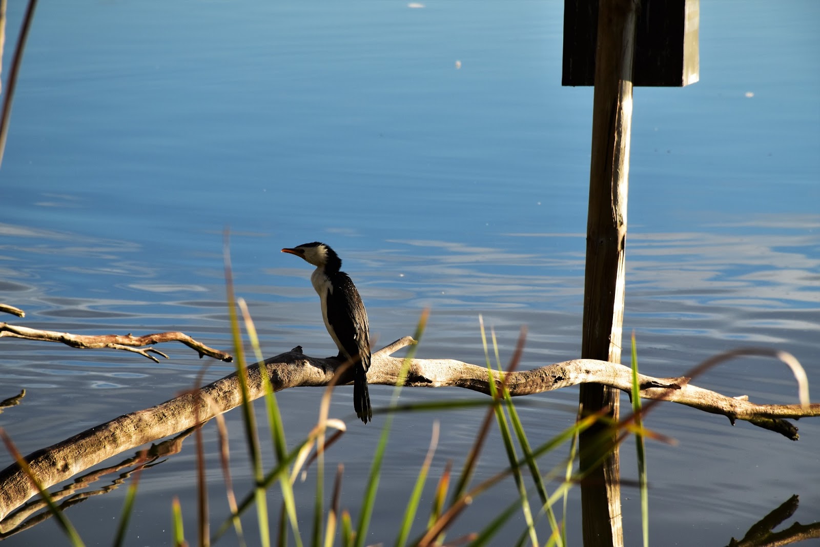
After leaving the Port of Sale area we headed along a short stretch of suburban road walking before arriving on the shore of Lake Guthridge. So far on our stroll we had been in more danger of being knocked over by a tumbleweed than by a person, but arriving on the shore of Lake Guthridge this morning that all changed very quickly. We were now suddenly surrounded by a sea of activewear as, what looked like the whole population of Sale had squeezed themselves into the lycra and were out for an early morning run. It turns out we had stumbled onto the course of Sale’s Park Run, so as we meandered our way along the southern shore of Lake Guthridge and then Lake Guyatt we were never lonely, we even managed to pick up a posse of ducks at one stage who seemed to want to tag along on our stroll.
 |
The streets of Sale were pretty quiet at this early hour.
 |
There were a lot of locals out and about at Lake Gutheridge.
 |
We got sensational weather......for awhile.
 |
Lake Gutheridge
 |
 |
The locals at Lake Guyatt were a little more aggressive!
 |
We picked up or own posse.
 |
 |
| We managed to miss the turn off to the Sale Powder Magazine, this old building dates all the way back to 1864, apparently. |
|
|
|
|
|
|
|
|
Leaving Lake Guyatt our route zigged and zagged it’s way out of Sale, crossed Flooding Creek and headed along Maxfields Street to enter the Sale Common Nature Conservation Reserve. Now I mentioned earlier that this is mostly a wetland walk so I figured winter was a good time to visit, in hindsight I’d have to say that after spring floods might be a better option as the wetlands were all bone dry on this visit at the end of June. Entering the Sale Common Sam and I headed for the signposted boardwalk, this long section of boardwalk striking out across the wetlands towards Flooding Creek. Unfortunately instead of water and water birds, we mostly got dry grass and reeds today. It wasn’t all doom and gloom though, the early morning sun was helping an the scenery side of things, although the approaching dark clouds weren’t filling me with optimism about the day ahead.
 |
Crossing Flooding Creek on our way out of town, yep the weather had turned already.
 |
Heading towards the Sale Common Nature Conservation Reserve along Maxfields Street the walk suddenly had a bit of a rural feel about it.
 |
Sam's heading out onto the first long section of boardwalk.
 |
The wetlands were mostly bone dry.
|
|
|
|
After the long section of boardwalk we arrived on the banks of Flooding Creek to find it more or less dry as well, not to worry it was still a nice enough walk as we followed the meandering course of the creek as it made it’s way towards the La Trobe River. It was while walking along here checking out the small billabongs and gnarly old Red Gums that the rain arrived, although thankfully it was only in the form of light showers at this stage. The walk along here follows a quiet 4wd track for a lot of the distance and with Flooding Creek on one side and the large wetlands on the other I’m thinking it would be a good spot when there is a bit of water about.
 |
There are a lot big old Red Gums along the banks of Flooding Creek.
 |
Back in the ye olde days cattle were grazed on Sale Common.
 |
Flooding Creek
 |
| I'm looking like I was on a bit of a mission, I think I was shitty with the showers coming down? |
|
|
|
It’s a fairly long walk along Flooding Creek, but eventually we arrived at the slow moving, wide, brown La Trobe River. With the light showers continuing on and off we wandered west along a dirt road beside the river towards the somewhat famous Sale Swing Bridge. This old bridge is heritage listed having been built in the 1880’s and is Australia’s oldest remaining swing bridge. The bridge still swings open now days a couple of times a week to let the bigger boats get down the La Trobe River towards the Gippsland Lakes. Climbing onto the deck of the bridge it was a good spot to check out the confluence of the Thomson and La Trobe River a hundred metres or so up stream, the turgid brown water here a marked contrast to the rushing clear water up in the mountains where I’m normally looking at these rivers.
 |
The walk follows this quiet road along the La Trobe River towards the Sale Swing Bridge.
 |
Sale Swing Bridge
 |
 |
The wide, slow moving La Trobe River.
 |
| The confluence of the La Trobe and Thomson Rivers. |
|
|
|
|
Leaving the Swing Bridge we started heading back in the general direction of Sale, there is no real danger of any navigational difficulties though, as for long sections I was walking near the very busy South Gippsland Highway on the way back into town. A little over a kilometre from the Swing Bridge our route headed back into the wetlands again, once again striking out across the swaying reeds of the dry swamp. There was a bit of water around on this section though, arriving at the aptly named Long Waterhole I was happy to see that the water birds still had somewhere to feed, although it looks like the water level is about 2 metres lower than normal. If it wasn’t for the sound of the traffic I could easily imagine that I was a fair way from civilisation along here as we wondered along through the Red Gums beside the waterhole.
 |
Back in the wetlands and heading for Sale.
 |
 |
| Long Waterhole was the only section of the wetlands that was wet on this visit. |
|
|
Leaving the Sale Common we passed underneath the South Gippsland Highway and any illusions of remoteness evaporated as we picked up a sealed path heading north along the banks of the Sale Canal. It was about now that the rain got a little more serious so for most of the remaining walk the DSLR was backed away safely in its dry bag. Luckily we didn’t have far to go on todays stroll as we followed the canal into town, after meeting our outward route we headed back through the Port of Sale Precinct to the old Visiter Information Centre, jumped into the ute and made the very short drive back to the Gippsland Art Gallery.
 |
Passing under the South Gippsland Highway, at least we are out of the showers for a minute.
 |
We followed this sealed path back into town along the bank of the Sale Canal.
 |
Things were getting a bit damper now.
 |
| The redeveloped Port of Sale Precinct is well worth a look. |
|
|
|
With the walking part of the day over now it was nice to sit back in the café in the gallery building and enjoy our lunch, while watching the rain tumble down outside through the floor to ceiling windows. After lunch we headed into the Gippsland Art Gallery to check things out, there has been a gallery in Sale going all the way back to 1965 but this wonderful new space was only opened in early 2018. Apart from the café, the modern building also houses the new Visiter Information Centre. If you find yourself down in Sale it’s worth checking out, just the building itself is very interesting before you even get to the art.
 |
| The gallery is a nice space. |
 |
 |
| This exhibition was by Annemieke Mein, the work is created by textiles. |
|


No comments:
Post a Comment