 |
| Wilhelmina Falls |
Murrindindi Scenic Reserve was another of those spots in Victoria that got torched in the Black Saturday Fires back in 2009, the fire not only decimating the bush but also causing 40 fatalities. Today I was heading back up to the reserve for the first time since that day, I was actually starting the walk not far from the old mill where the Murrindindi Fire was thought to have started. Like all of the walks that I do through areas that have been severely burnt in the recent past I wasn’t expecting things on the ground to be quite as good as they were pre fires, but it’s always interesting to see how the bush is regenerating.
 |
| The Suspension Bridge at the Murrindindi Camping Area. |
I arrived at the walks start at the Murrindindi Camping Area late morning on this Friday, once again it looked like I’d managed to get a nice winters day, with blue sky overhead. Pulling on my boots I set off towards what is probably the highlight of this walk, Wilhelmina Falls. Passing through the deserted camp I crossed the Murrindindi River on the substantial suspension bridge and headed up stream on the very good walking track. The Murrindindi Scenic Reserve is a small parcel of bush within the large Toolangi State Forest, one of the better managed state parks from what I can see and the infrastructure for walkers on this walk is very good.
 |
| Murrindindi River |
Initially I followed the beautiful Murrindindi River upstream for a couple of kilometres along the Murrindindi Walking Track, this track runs almost the length of the reserve and is a really good walk in itself. The good news is that, with the track running very close to the river in spots I wasn’t battling an impenetrable wall of regrowth trying to get a view of the river along here. After passing a walk in camp (that I’ve got filed away in my memory for a future walk) and the substantial SEC Bridge I reached the turn off to Wilhelmina Falls and started to climb away from the river.
 |
Initially my walk stayed pretty close to the river.
 |
 |
I passed through this walk in camp site.
 |
The walking infrastructure is very good in this little park.
 |
| The environment is pretty damp down near the river. |
|
|
|
|
It’s a climb of around 100 metres to the Wilhelmina Falls Lookout but spread over a kilometre it’s a pretty easy climb. Once away from the the Murrindindi River the forest gets a bit drier and opens up a bit, the country also gets a bit rockier with the track climbing the occasional rock out crops making for interesting walking. Arriving at the Wilhelmina Falls Lookout side trip I dropped the pack and made the short side trip. The Wilhelmina Falls Lookout is at the base of the falls and not the top, it still allows for a great view though.
 |
Climbing up towards Wilhelmina Falls the country gets a bit rockier.
 |
The Wilhelmina Falls Lookout is at the base of these rock slabs.
|
|
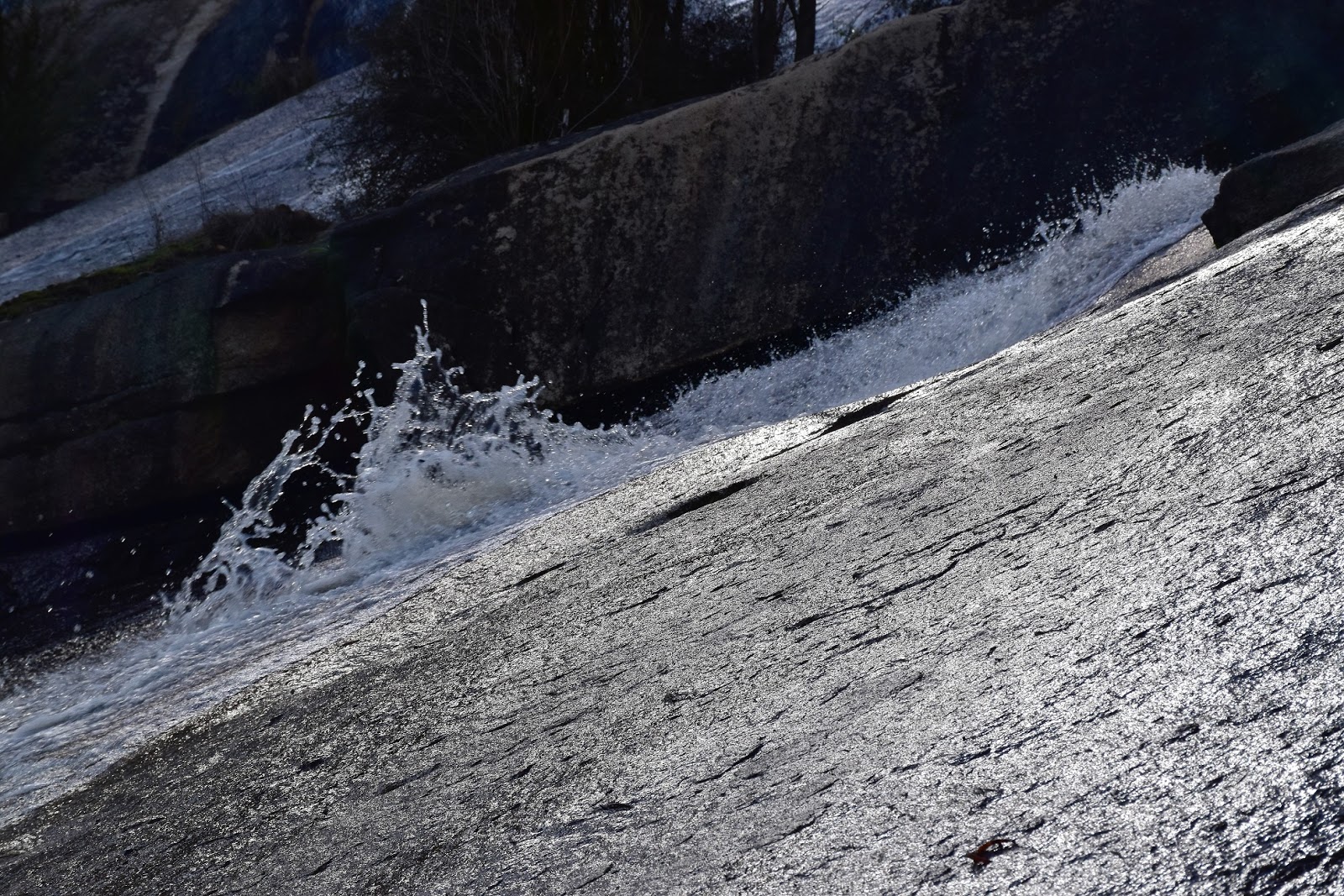
Wilhelmina Falls are where Falls Creek plunges down steep, smooth granite slabs as the water flows down towards the Murrindindi River. These are one of the more scenic waterfalls close to Melbourne I think. I’m guessing that these slabs of granite must be thirty to forty metres high and with Falls Creek having a reasonable flow today it made an impressive sight. The sunlight reflecting on the water as it cascaded down the smooth granite was particularly photogenic today I thought. After soaking up this magic spot for awhile I wandered back to the track, grabbed my pack and started to climb a long series of metal steps to the top of the falls. These staircases not only allow for a safe way to climb the granite slabs but also give a few more glimpses of Wilhelmina Falls, the base of the waterfall is still the best spot to check out the falls though.
 |
 |
Hmmm.....time to start climbing.
 |
There were a few reasons to stop on the climb.
 |
| The staircase also allows for some glimpses of the falls. |
|
|
|
Once above the falls my track climbed a little more and soon met up with Boroondara Walking Track. This walking track is named after, and maintained by, the Boroondara Bushwalking Club and was the bit of the walk that I was thinking might be a little overgrown and ordinary after the fires. Turning onto the track today though all was pretty good as I continued to climb up to my walks high point, while the regrowth was thick and impenetrable, the track was clear. Boroondara Walking Track meanders around a little before starting it’s steepish descent back down towards the Murrindindi River, the descent was a little damp and slippery but luckily my (dead) cat like reflexes kept me upright this afternoon.
 |
Looking back across the Murrindindi River Valley towards Mt Despair.
 |
The tracks in the Murrindindi Scenic Reserve are generally well sign posted.
 |
There's plenty of evidence left over from the fires.
 |
| Topping out on Boroondara Walking Track. |
|
|
|
When the steepest part of the descent down Boroodara Walking Track over the route tracks along a damp gully beside a small cascading creek, for the most part this small creek is heard and not seen but there are a couple of spots where you can get glimpses of the water through the bush. Eventually I emerged from the scrub at a car park on Falls Road. From the small car park I once again picked up the Murrundindi Walking Track, only now I was heading down stream. The Murrindindi Walking Track generally contours the slopes a fair bit above the river along here so I don’t think it’s quite as scenic as the lower sections.
 |
In some spots the fire regrowth forms an almost impenetrable wall.
 |
There are still enough mature trees to make things interesting though.
 |
The Boroondara Bushwalking Club is doing a pretty good job keeping this track clear I'm thinking.
 |
| Before reaching Falls Road Boroondara Walking Track follows his small creek for awhile. |
|
|
|
It was close to three kilometres before the Murrundindi Walking Track dropped back down to meet the Wilhelmina Track. On the way down I crossed a few gullies and got some glimpses down towards the river and over towards Mt Despair, but for the most part this section is just a forest walk, albeit a nice forest walk, especially in the ferny damper sections. Meeting my outward route I had the best section of the river walk to retrace, heading downstream I once again took a few short detours to check out this pretty river. Arriving back at the imaginatively named Suspension Bridge I crossed over and I was back at the ute, the walk was over.
 |
Heading downstream along the Murrindindi River Walking Track, for the most part the track is a fair way above the river along this section.
 |
The Mt Despair Fire Tower on the other side of the valley.
 |
 |
| I took one last look at the Murrindindi River as I got back to the ute. |
|
|
|
The Dirt.
According to my very optimistic GPS I walked 17.1 kilometres and climbed 553 metres on this medium grade walk. If you check out the GPS trace on my map you’ll see the route meandering around a bit as I finished the walk, that’s just my GPS trying to push up my stats as I actually was retracing my mornings outward route almost exactly. I used notes and map from the House of Chapman’s book
Day Walks Melbourne, which along with my GPS map and park notes was all I really needed to do this walk. Wilhelmina Falls are the undoubted highlight of this walk, like all waterfalls they are best after decent rains, the start and ending sections of the walk along the Murrindindi River also make for a very pretty little stroll. The good news today was that the Murrindindi Scenic Reserve is recovering well after the fires, while the bush has a bit to go all the infrastructure and tracks were in good condition and it’s definitely worth a visit.
Relevant Posts.


No comments:
Post a Comment