 |
My meagre vocabulary can't really do justice to the scene this morning.
 |
| By the time I left the summit I was adrift in a sea of cloud. |
|
I had a very comfortable night perched up on top of Mt Langhi Ghiran. After over 12 hours in my bivy bag though I was pretty keen to crawl out this morning and stagger up on to two feet again. With blue sky and sunshine overhead it looked like I’d got lucky with the weather again, but on crawling out of my sleeping bag it was soon very apparent that whilst the sun was out, it was bloody cold…finger achingly cold actually. Whilst pulling on all of the clothes that I’d lugged up here I glanced out across the plains to the south and noticed a sea of fog. After watching the fog for awhile it appeared that it was slowly creeping towards me, hmm that might make things interesting if it envelopes the mountain as I had a lot of off piste stuff in front of me today.
 |
The view from my bivy.
 |
After 12 hours laying on the ground I was looking remarkably happy.
 |
The view over towards Mt William and the Major Mitchell Plateau after I emerged from my bivy bag.
 |
Looking a little further south along the Serra Range towards Mt Abrupt and Mt Sturgeon.
 |
Looking north-east things were a bit clearer.
|
|
|
|
|
Breakfast today was a couple of yesterday’s left over Maccas muffins, unfortunately washed down by cold water and not a hot coffee. My rather uninspiring breakfast was more than compensated for by the view though. The fog that I’d thought was creeping it’s way north was indeed on the move. The Challicum Hills Wind Farm now had it’s windmills seemingly floating in the clouds in one direction, the Serra and William Ranges in the Grampians appearing like sharks teeth above the fog in another direction. To my north and east I had the fingers of the fog slowly creeping across the plains. This is another of those times that my year 10 vocabulary really isn’t adequate to paint a word picture of the scene before me, thankfully I also had a camera!
 |
Time to pack up, I suppose.
 |
And still the fog crept closer.
 |
 |
Who says I'm not a morning person? Like I've said before only the most flattering photos get onto my blog!
 |
 |
It wasn't all long range views from the summit.
|
|
|
|
|
|
Eventually I decided that I’d better shuffle off back towards the ute. I wasn’t going back the way I’d came though, I was going to drop down a ridge to the west and make a bit of a circuit of the walk. Like setting up camp last night, breaking camping this morning was a pretty quick affair, with most of my gear a little damp then I’d need to air it when I got home, so I just shoe horned everything into my pack with little finesse and set off. From the summit I could see a valley below me but I was actually aiming for another valley one ridge line away, before I’d get there though I had to get off the summit.
 |
 |
The fingers of fog were still creeping across the plains.
|
|
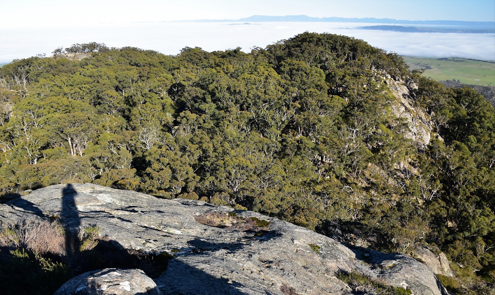
Dropping to the west off the summit needed a little caution, the slabs of granite drop steeply and get even steeper lower down, it would be easy to get yourself into a spot that would be hard to scramble out of. After some judicious route finding I reached the soft level grass of the saddle after around twenty minutes, this little saddle is a magic spot and would be a great spot to camp if you weren’t spending the night on the summit. From the saddle I contoured around the ridge a little passing beneath some huge rock slabs slightly to the south.
 |
There were lots of granite slabs to descend first thing this morning.
 |
I was dropping into this saddle.
 |
The country down here is a world away from the typical north-western Victorian type of scenery.
 |
| I'm going to drop into this valley one day and check it out. |
|
|
|
After avoiding the slabs I climbed very gently into a broad saddle, it’s important to identify this spot (it’s where the ridge line starts to swing south and then south east). Like the first saddle this spot is another beautiful spot, with plenty of mature trees and huge moss covered granite rocks it feels a world away from the nearby flat Wimmera Plains. After passing through this saddle I started dropping down a long spur to the south, things were pretty steep and rocky up the top but the lower down I got, the more the descent eased. Thankfully the scrub was pretty easy to negotiate but it did get a little thicker as I dropped down.
 |
The second saddle with littered with big rocks.
 |
 |
After passing through the saddle I headed down this spur, the fog was still lingering.
 |
| The scrub was pretty reasonable today so the off track stuff was very enjoyable. |
|
|
|
Once down in the valley I was looking to intersect with an old 4wd track that runs east west, pushing through the scrub I found some kind of feral animal trap instead. I’d noticed that the ground had been rooted up a bit on my descent but I’m not sure what kind of feral animals had done the damage, it didn’t look like pigs or goats so I’m wondering if it’s deer that are a problem up here. Rationalising that the trap wouldn’t be far from the old 4wd track I pushed on a little further and did indeed emerge onto the wide open spaces of the 4wd track. Navigation wise everything would now be pretty straight forwards for the rest of the day but I still had a fair days walk ahead of me.
 |
Down in the valley I was looking for an old 4wd track.
 |
Anyone know what type of feral animal this is for?? I know it's not for Feral walkers because they didn't have a cold beer in there to entice me in!
 |
| The old track that I'd been looking for, Lagoon Track. |
|
|
Meandering my way along the old track it was only a couple of minutes until I reached the sign post indicating the side trip to Hidden Lagoon. Unfortunately Hidden Lagoon was dry on my visit, a situation that is fairly common nowadays I’m hearing. After wandering around the lagoon for awhile I returned to the track junction, grabbed my pack and set off again down Lagoon Track, once again descending gently, now down the valley of Billy Creek. The walk along this closed track was pretty nice, with plenty of ferns, big Stringybarks and the ubiquitous granite rocks to be seen. I was in a good head space this morning.
 |
Hidden Lagoon, unfortunately it's dry more often than not nowadays.
 |
 |
Heading down Lagoon Track the walking was now very civilised.
|
|
|
On reaching Link Track I climbed a little and then started the descent down towards Langhi Ghiran Track, it looks like the fairly steep Link Track has been closed to vehicles for a fair while but apart from a couple of trees across the track the walking was good. Dropping down Link Track I was once again able to get some views to the south and west, as it was now almost lunch time I was a little surprised to see the fog still covering the plains below me. After one last steep pinch I emerged from the scrub onto the substantial Langhi Ghiran Track, the walk was coming to it’s end.
 |
Link Track climbed a little before descending in earnest.
 |
Three hours after I left the summit the fog was still holding it's ground.
 |
Link Track must of been a steep little drive when it was open to vehicles.
 |
One last look across to Mt William and the Major Mitchell Plateau, from Link Track.
|
|
|
|
While the walk was going to be all pretty cruisey now until I got back to the ute, there was still a few kilometres of road bashing ahead of me. It’s on these road bashes that I find that it’s sometimes better to just put my head down and get on with it, if I faff about too much these road walks seem to take forever. My tactics on these stretches of my walks are to think about ‘happy’ places, getting my mind in a good place almost works like meditation and I find I can cover some big kilometres at a descent speed. My meditative state today was only really broken by the occasional kangaroo or wallaby crashing through the scrub beside me. After short cutting a few of the corners on the meandering Langhi Ghiran Track I spotted the ute through the trees and my walk was over. Pulling off my boots I jumped in and headed off on the three hour drive home.
 |
Langhi Ghiran Track made for quick walking this afternoon.
 |
 |
I had the occasional wobbly to snap me out of my revery.
|
|
|
The Dirt.
According to my GPS I walked 11.8 kilometres and climbed 94 metres on what I’d class a medium grade days walking. Over the two days of my Mt Langhi Ghiran adventure I walked 20 kilometres and climbed 640 metres on his medium grade walk. Most people do this stroll as day walk, if I was doing the complete circuit in a day then it would be a hard days walking. This is a surprisingly good walk, I was thinking that the bivy on the summit and the views would be the highlight and they were, but this walk isn’t a one trick pony, the valleys to the south of the summit are wild and beautiful spots, so much so that I’m already thinking about heading back and exploring one that I missed on this walk. I got by on this walk with Mr Tempest’s notes and map out of his
Daywalks Around Victoria book, the parks notes and my GPS maps, however as a fair chunk of the two day walk is off piste it pays to have more information than you’ll think you’ll need, not less. The off track stuff requires a bit of concentration, particularly picking the saddle to pass through to pick up the spur running down to Hidden Lagoon.
Relevant Posts.
Langhi Ghiran Walk, Day 1, Langhi Ghiran State Park, 2018.
Mt Wudjub-Guyun & Gulgurn Manja Rock Art, Grampians National Park, 2018.
Troopers Creek to Halls Gap, Grampians National Park, 2004.
 |
| The open scrub allowed me to short cut sections of Langhi Ghiran Track. |
 |
| Back at the Langhi Ghiran Visitor Area, time to head home. |


mate i love reading your blog - chatty and cheerful and informative. good on ya.
ReplyDeleteThanks mate, I'm happy someone enjoys my waffle!
Delete