
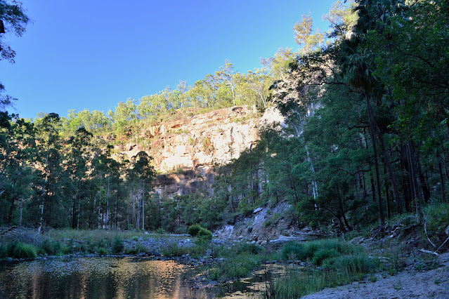
The view back down towards Carnarvon Gorge from the Battleship Spur Lookout is a bushwalking classic I think.
I was up reasonably early today - but not as early as Steve and Kim who had a thirty plus kilometre day in front of them though, after wishing them all the best I slowly packed up my camp. From what I could see at the bottom of the gorge the weather looked beautiful again, which meant that I'd be sweating bullets once I climbed out of the gorge later this morning.

The sun takes awhile to reach the Big Bend Camp.

Big Bend.

Big Bend - the camp is in the trees on the left.
I eventually hit the trail at around 8:30am, firstly backtracking down the creek to get to the entrance of Boowinda Gorge which I followed for almost a kilometre along the bed of the creek. The walls of Boowinda Gorge close right in to almost touching distance on both sides through here, not a place to be caught in a flash flood. The 'get-up' out of the gorge is an incredibly steep fifteen minute climb where I was using hands and legs to make my way to the top. On reaching the top I dropped the pack for awhile and took a photo of the sign warning inexperienced walkers not to proceed.
The sun still hadn't hit me yet.

This is the spot where I left the main gorge and entered Boowinda Gorge.

Boowinda Gorge.

Boowinda Gorge.


Boowinda Gorge - this isn't a spot to be caught in a flash flood.

Hmm... this looks serious.

I was now out of the gorge and copping the full brunt of the sun.
The ascent was fairly reasonable once I'd scrambled out of Boowinda Gorge.


I did have a bit of scree to negotiate in one spot.


That's the Battleship Spur Lookout in the distance.
It was around 11:30 am when I finally dropped my pack at the lookout on Battleship Spur, below me Carnarvon Gorge snaked its way into the distance and I was able to trace my complete route so far. There were a couple of day walkers on top whilst I was there including one bloke who'd lost his mate on the walk up, he decided to head down and see if he could find him, little did I know that wouldn't be the last I'd hear of that.

With the country starting to fall away steeply...

... I sidled around a big rock buttress...

... and arrived at the ladder.

Back in the ye olde days I had to climb the roots and rock at this spot.

The climbing is almost over for the day.

And there we go.
I spent a wonderful two hours at the lookout taking a few photo's and soaking in the view, eating some more salami and cheese, and talking to a beautiful young lady who's name was Emily I think. Emily arrived on top without a bead of sweat on her, she stood out from most people that I'd seen so far on the walk in that she actually knew what she was doing. I passed a pleasant hour talking to her about some of the walks she had done with her dad, I think she made me look a bit soft as she had done some very hardcore routes.


Carnarvon Gorge from Battleship Spur.


It's not just the gorge views that are impressive from Battleship Spur.

As I still had close to ten kilometres to go to reach camp for the night I eventually had to make a move, firstly retracing a few hundred metres to the turn off back to the gorge, and then striking out into the more remote country of the Mount Moffat section of the park. I was now well off the tourist path so after walking for half an hour I was surprised to see some movement in the distance, I lost it for a minute in the trees and then picked it up again well to the north of the track. It was a bloke with a day pack wandering into the never-never, when I got close enough to him I yelled out to get his attention and convinced him to come back to where I'd now dropped my pack. It turns out that this was the lost day walker. I now had a bit of a dilemma, as he couldn't follow the rough bushwalking pad I thought it was best that I took him back and put him on to the track down to the gorge. I would now be cutting it fine to get to my intended camp (and water) before dark, the rough pad would be difficult to follow in the dark. I was a little surprised therefore when on getting him back to the descent track back to the gorge he said that he was going to head up to the lookout first, I said that people will be looking for him as his mate would have raised the alarm, however he said that this was the second time he had attempted Battleship Spur (he didn't make it last time!) and that it would be a shame not to go to the top! It was now 8.5 hours since he had started walking and at best he had 4 hours of daylight to get back, hmmm. Anyway, after explaining to him the importance of not walking on if he couldn't see any markers I headed back up the track to get my pack and carry on.

Laeving the lookout. The visitor centre is half a day away to the left - I was going straight on.

The track was a little less defined however it was still easy enough to follow.

I was now slowly losing height.
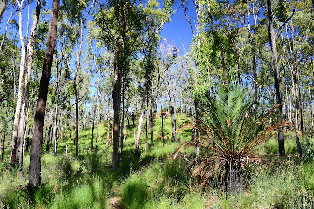
Luckily for me for the rest of my days the route trended down hill, so whilst the ground was sometimes rough and the pad indistinct I was able to make fairly good progress. It was actually beautiful country to walk through, with generally sparse tree cover and long green grass, it sometimes looked too perfect to be natural. Eventually I started to follow a creek line and was happy to note a couple of pools deep enough for a swim, maybe I'd get lucky tomorrow when I'd have more time.


Being early in the dry season the country was looking very lush and green.

After one particularly rough section of creek bed walking the pad stuck out due west towards Gadd's Camp, the late afternoon sun giving me the shits when I was trying to locate track markers. The track was generally OK to follow but I'd sometimes have to try and locate markers where the route crossed creeks as there were plenty of animal pads that looked more well worn than the actual route. Crossing one last small hill the track was suddenly at Gadd's Walkers Camp, the good news was that I still had a good hour of daylight left.

Thankfully I really enjoyed this type of country - I'd spend most of the next 5 days walking through similar country.

After setting up camp I rigged up a rough shower with my MSR Dromedary water bag, wandering around starkers for awhile while I dried of in the last of the sun. After dinner I was into the tent before 7 pm again to do a bit of reading and a lot of sleeping, leaving the tent fly open I was able to watch the stars from my sleeping bag but, at the same time I had enough coverage to keep the heavy dew off me.

There was a bit of water left over from the wet season.


My afternoons walk faetured one pretty rough section along this dry creek bed.

The Dirt.
I walked around 17 kilometres today and climbed about 698 metres on what I'd call a medium grade days walking. The day is really split into two parts, the first part is the solid climb up to the Battleship Spur Lookout and the second part was more of an easier undulating walk across lightly wooded grassy tablelands. I used the Carnarvon Great Walk topo map today along with my GPS.
Relevant Posts.

DRopping down towards Gadd's Camp in the late afternoon.

Gadd's Camp.

It's tent o'clock.


No comments:
Post a Comment